Grade I listed buildings in Staffordshire

Map all coordinates using OpenStreetMap
Download coordinates as:
- KML
- GPX (all coordinates)
- GPX (primary coordinates)
- GPX (secondary coordinates)
There are over 9000 Grade I listed buildings in England. This page is a list of these buildings in the county of Staffordshire, by district.
City of Stoke-on-Trent
| Name | Location | Type | Completed [note 1] | Date designated | Grid ref.[note 2] Geo-coordinates | Entry number [note 3] | Image |
|---|---|---|---|---|---|---|---|
| Trentham Mausoleum | Trentham | Mausoleum | c. 1808 | 19 April 1972 | SJ8680441062 52°58′00″N 2°11′53″W / 52.966754°N 2.197922°W / 52.966754; -2.197922 (Trentham Mausoleum) | 1210451 |  More images |
East Staffordshire
| Name | Location | Type | Completed [note 1] | Date designated | Grid ref.[note 2] Geo-coordinates | Entry number [note 3] | Image |
|---|---|---|---|---|---|---|---|
| Blithfield Hall | Blithfield Park, Blithfield | Country House | 16th century | 10 January 1953 | SK0449823934 52°48′47″N 1°56′05″W / 52.812932°N 1.934708°W / 52.812932; -1.934708 (Blithfield Hall) | 1190006 |  More images |
| Church of St Leonard | Blithfield | Parish Church | c. 1300 | 12 January 1966 | SK0441623991 52°48′48″N 1°56′09″W / 52.813445°N 1.935923°W / 52.813445; -1.935923 (Church of St Leonard) | 1294024 |  More images |
| Church of St Modwen | Burton upon Trent | Parish Church | 1719-26 | 24 March 1950 | SK2509922715 52°48′05″N 1°37′45″W / 52.801413°N 1.629161°W / 52.801413; -1.629161 (Church of St Modwen) | 1214046 |  More images |
| Croxden Abbey | Croxden | Abbey | 1179–1280 | 12 January 1966 | SK0658339695 52°57′17″N 1°54′12″W / 52.954592°N 1.903461°W / 52.954592; -1.903461 (Croxden Abbey) | 1230576 |  More images |
| Church of the Holy Angels | Hoar Cross | Church | 1872-78 | 12 March 1964 | SK1248723046 52°48′17″N 1°48′58″W / 52.804825°N 1.816214°W / 52.804825; -1.816214 (Church of the Holy Angels) | 1038507 |  More images |
| Church of St Chad | Burton upon Trent | Church | 1903 | 22 June 1979 | SK2461424458 52°49′02″N 1°38′10″W / 52.817104°N 1.636224°W / 52.817104; -1.636224 (Church of St Chad) | 1038702 |  More images |
| Church of St John the Baptist | Mayfield | Parish Church | Late 12th century | 12 January 1966 | SK1542844752 53°00′00″N 1°46′18″W / 52.99987°N 1.771566°W / 52.99987; -1.771566 (Church of St John the Baptist) | 1230760 |  More images |
| Wootton Lodge | Wootton Park, Ramshorn | Country House | c. 1600 | 10 January 1953 | SK0956343800 52°59′29″N 1°51′32″W / 52.991448°N 1.858984°W / 52.991448; -1.858984 (Wootton Lodge) | 1278308 |  More images |
| Church of St Mary | Rolleston on Dove | Parish Church | 12th century | 12 March 1964 | SK2356427718 52°50′47″N 1°39′06″W / 52.846455°N 1.65157°W / 52.846455; -1.65157 (Church of St Mary) | 1374442 |  More images |
| Church of St Mary | Tutbury | Parish Church | 1160-70 | 12 March 1964 | SK2111829107 52°51′33″N 1°41′16″W / 52.859042°N 1.687797°W / 52.859042; -1.687797 (Church of St Mary) | 1038524 |  More images |
| Tutbury Castle | Tutbury | Castle | 12th century | 26 April 1984 | SK2092429117 52°51′33″N 1°41′26″W / 52.85914°N 1.690678°W / 52.85914; -1.690678 (Tutbury Castle) | 1374431 |  More images |
Lichfield District
| Name | Location | Type | Completed [note 1] | Date designated | Grid ref.[note 2] Geo-coordinates | Entry number [note 3] | Image |
|---|---|---|---|---|---|---|---|
| Church of All Saints | Alrewas | Parish Church | 13th century | 20 November 1986 | SK1676915267 52°44′05″N 1°45′11″W / 52.734781°N 1.753093°W / 52.734781; -1.753093 (Church of All Saints) | 1038926 | 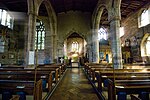 More images |
| Church of St Andrew | Clifton Campville | Parish Church | Early 13th century | 27 February 1964 | SK2529010784 52°41′39″N 1°37′38″W / 52.694152°N 1.627244°W / 52.694152; -1.627244 (Church of St Andrew) | 1038808 |  More images |
| Church of St Michael and All Angels | Hamstall Ridware | Parish Church | 12th century | 27 February 1964 | SK1056519346 52°46′18″N 1°50′41″W / 52.771605°N 1.844842°W / 52.771605; -1.844842 (Church of St Michael and All Angels) | 1190715 |  More images |
| Church of All Saints | Kings Bromley | Parish Church | 16th century | 27 February 1964 | SK1220817025 52°45′03″N 1°49′14″W / 52.750706°N 1.820575°W / 52.750706; -1.820575 (Church of All Saints) | 1277769 |  More images |
| Cathedral Church of the Blessed Virgin Mary and St Chad | Lichfield | Cathedral | 19th century | 5 February 1952 | SK1156309742 52°41′07″N 1°49′49″W / 52.685249°N 1.830385°W / 52.685249; -1.830385 (Cathedral Church of the Blessed Virgin Mary and St Chad) | 1298431 |  More images |
| Erasmus Darwin House | Lichfield | House | c. 1758 | 5 February 1952 | SK1141209709 52°41′06″N 1°49′57″W / 52.684956°N 1.83262°W / 52.684956; -1.83262 (Erasmus Darwin House) | 1187355 |  More images |
| Hospital of St John Baptist without the Barrs | Lichfield | Almshouse and chapel | 19th century | 5 February 1952 | SK1175409131 52°40′47″N 1°49′39″W / 52.679753°N 1.827581°W / 52.679753; -1.827581 (Hospital of St John Baptist without the Barrs) | 1218231 |  More images |
| Samuel Johnson Birthplace Museum | Lichfield | Timber Framed House | c. 1707 | 5 February 1952 | SK1173009542 52°41′00″N 1°49′41″W / 52.683448°N 1.827921°W / 52.683448; -1.827921 (Samuel Johnson Birthplace Museum) | 1292492 | 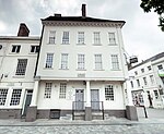 More images |
| Master's House to rear of Hospital of St John Baptist without the Barrs | Lichfield | Teachers House | cira 1495 | 5 February 1952 | SK1172909178 52°40′49″N 1°49′41″W / 52.680176°N 1.827949°W / 52.680176; -1.827949 (Master's House to rear of Hospital of St John Baptist without the Barrs) | 1298403 |  More images |
| St Chad's Cathedral School and Chapel | Lichfield | Bishops Palace | 1687-8 | 5 February 1952 | SK1156009830 52°41′10″N 1°49′50″W / 52.68604°N 1.830426°W / 52.68604; -1.830426 (St Chad's Cathedral School and Chapel) | 1218871 |  More images |
| Church of St Nicholas | Mavesyn Ridware | Parish Church | 13th century | 27 February 1964 | SK0816216871 52°44′58″N 1°52′50″W / 52.749397°N 1.880521°W / 52.749397; -1.880521 (Church of St Nicholas) | 1249035 |  More images |
| Gatehouse at Old Hall | Mavesyn Ridware | Gatehouse | 14th century | 27 February 1964 | SK0812916781 52°44′55″N 1°52′52″W / 52.748589°N 1.881012°W / 52.748589; -1.881012 (Gatehouse at Old Hall) | 1249047 |  More images |
Newcastle-under-Lyme
| Name | Location | Type | Completed [note 1] | Date designated | Grid ref.[note 2] Geo-coordinates | Entry number [note 3] | Image |
|---|---|---|---|---|---|---|---|
| Church of St Margaret | Betley | Parish Church | 17th century | 17 November 1966 | SJ7556348459 53°01′58″N 2°21′57″W / 53.032849°N 2.365848°W / 53.032849; -2.365848 (Church of St Margaret) | 1038581 |  More images |
| Church of All Saints | Madeley | Parish Church | 12th century | 17 November 1966 | SJ7730144377 52°59′46″N 2°20′23″W / 52.996233°N 2.339644°W / 52.996233; -2.339644 (Church of All Saints) | 1206195 | 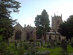 More images |
| Whitmore Hall | Whitmore | House | Late 19th century | 2 December 1952 | SJ8109041266 52°58′06″N 2°16′59″W / 52.968415°N 2.283009°W / 52.968415; -2.283009 (Whitmore Hall) | 1206579 |  More images |
South Staffordshire
| Name | Location | Type | Completed [note 1] | Date designated | Grid ref.[note 2] Geo-coordinates | Entry number [note 3] | Image |
|---|---|---|---|---|---|---|---|
| Weston Park and service wings to north and east | Weston Park, Weston-under-Lizard | Country House | 17th century | 16 May 1953 | SJ8064010629 52°41′35″N 2°17′16″W / 52.692994°N 2.287881°W / 52.692994; -2.287881 (Weston Park and service wings to north and east) | 1039264 |  More images |
| Bridge at Weston Park | Weston Park, Weston-under-Lizard | Bridge | 1760s | 16 May 1953 | SJ8131810383 52°41′27″N 2°16′40″W / 52.690806°N 2.277836°W / 52.690806; -2.277836 (Bridge at Weston Park) | 1039268 |  More images |
| Temple of Diana at Weston Park | Weston Park, Weston-under-Lizard | Garden House | c. 1760 | 16 May 1953 | SJ8104310441 52°41′29″N 2°16′55″W / 52.691318°N 2.281907°W / 52.691318; -2.281907 (Temple of Diana at Weston Park) | 1188135 | 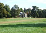 More images |
| St Andrew's Church, Weston-under-Lizard | Weston-under-Lizard | Church | c. 1701 | 19 March 1962 | SJ8061210649 52°41′35″N 2°17′18″W / 52.693173°N 2.288296°W / 52.693173; -2.288296 (St Andrew's Church, Weston-under-Lizard) | 1294950 | 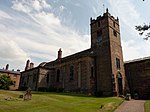 More images |
| St Mary's Church, Blymhill | Blymhill | Tower | Early 15th century | 19 March 1962 | SJ8085112234 52°42′27″N 2°17′05″W / 52.70743°N 2.284853°W / 52.70743; -2.284853 (St Mary's Church, Blymhill) | 1039272 | 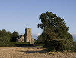 More images |
| Chillington Hall | Chillington Park, Brewood | Country House | 1724 | 16 May 1953 | SJ8636606776 52°39′31″N 2°12′11″W / 52.658533°N 2.203001°W / 52.658533; -2.203001 (Chillington Hall) | 1060191 |  More images |
| Church of St Mary and St Chad | Brewood | Parish Church | 13th century | 19 March 1962 | SJ8834908664 52°40′32″N 2°10′26″W / 52.675552°N 2.173752°W / 52.675552; -2.173752 (Church of St Mary and St Chad) | 1060197 |  More images |
| The Grecian Temple at Chillington Hall | Chillington Park, Brewood | Garden Temple | Late 18th century | 16 May 1953 | SJ8540205371 52°38′45″N 2°13′02″W / 52.645877°N 2.21719°W / 52.645877; -2.21719 (The Grecian Temple at Chillington Hall) | 1295261 |  More images |
| Hilton Hall | Hilton Park, Hilton | Country House | 1720-30 | 16 May 1953 | SJ9521005184 52°38′40″N 2°04′20″W / 52.644373°N 2.072228°W / 52.644373; -2.072228 (Hilton Hall) | 1039174 |  More images |
| The Conservatory at Hilton Hall | Hilton Park, Hilton | Conservatory | Early 19th century | 16 May 1953 | SJ9513005274 52°38′43″N 2°04′24″W / 52.645181°N 2.073411°W / 52.645181; -2.073411 (The Conservatory at Hilton Hall) | 1039176 |  Upload Photo |
| Church of St Peter | Kinver | Church | 14th century | 27 June 1963 | SO8461483049 52°26′43″N 2°13′40″W / 52.445185°N 2.227794°W / 52.445185; -2.227794 (Church of St Peter) | 1230950 |  More images |
| Church of All Saints | Lapley | Parish Church | 12th century | 19 March 1962 | SJ8724012934 52°42′50″N 2°11′25″W / 52.713912°N 2.190321°W / 52.713912; -2.190321 (Church of All Saints) | 1374057 |  More images |
| Patshull Hall and north west and north east wings to north forecourt | Patshull Park, Pattingham | Country House | 18th century | 16 June 1953 | SJ8024600931 52°36′21″N 2°17′35″W / 52.605799°N 2.293126°W / 52.605799; -2.293126 (Patshull Hall and north west and north east wings to north forecourt) | 1039327 |  More images |
| Triumphal entry to forecourt of Patshull Hall and flanking screen walls | Patshull Park, Pattingham | Gatehouse | c. 1750 | 16 June 1953 | SJ8022600953 52°36′22″N 2°17′36″W / 52.605996°N 2.293423°W / 52.605996; -2.293423 (Triumphal entry to forecourt of Patshull Hall and flanking screen walls) | 1294872 | |
| Church of St Michael and All Angels | Penkridge | Collegiate Church | 13th century | 19 March 1962 | SJ9214414160 52°43′30″N 2°07′04″W / 52.725028°N 2.117758°W / 52.725028; -2.117758 (Church of St Michael and All Angels) | 1039195 |  More images |
Stafford Borough
| Name | Location | Type | Completed [note 1] | Date designated | Grid ref.[note 2] Geo-coordinates | Entry number [note 3] | Image |
|---|---|---|---|---|---|---|---|
| Barlaston Hall | Barlaston | Country House | 1756-8 | 10 January 1953 | SJ8944239114 52°56′57″N 2°09′31″W / 52.949302°N 2.158581°W / 52.949302; -2.158581 (Barlaston Hall) | 1374172 |  More images |
| Church of St Mary and All Saints | Bradley | Church | Late 13th/early 14th century | 15 January 1968 | SJ8795618050 52°45′36″N 2°10′48″W / 52.759919°N 2.179911°W / 52.759919; -2.179911 (Church of St Mary and All Saints) | 1319799 |  More images |
| Church of All Saints | Chebsey | Church | 13th century | 24 January 1967 | SJ8596828586 52°51′16″N 2°12′35″W / 52.854583°N 2.209826°W / 52.854583; -2.209826 (Church of All Saints) | 1374173 |  More images |
| Shugborough Hall | Colwich | Country House | c. 1695 | 17 March 1953 | SJ9922422493 52°48′00″N 2°00′47″W / 52.799995°N 2.012951°W / 52.799995; -2.012951 (Shugborough Hall) | 1079637 |  More images |
| Chinese House at Shugborough Hall | Colwich | Garden Building | c. 1747 | 17 March 1953 | SJ9924922718 52°48′07″N 2°00′45″W / 52.802018°N 2.01258°W / 52.802018; -2.01258 (Chinese House at Shugborough Hall) | 1358640 | 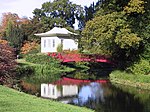 More images |
| Dark Lantern at Shugborough Hall | Colwich | Garden Feature | c. 1765 | 17 March 1953 | SJ9848321938 52°47′42″N 2°01′26″W / 52.795004°N 2.023938°W / 52.795004; -2.023938 (Dark Lantern at Shugborough Hall) | 1065771 |  More images |
| Doric Temple at Shugborough Hall to north of the house | Colwich | Garden Temple | c. 1760 | 15 January 1968 | SJ9925322579 52°48′03″N 2°00′45″W / 52.800768°N 2.012521°W / 52.800768; -2.012521 (Doric Temple at Shugborough Hall to north of the house) | 1079641 | 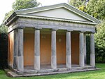 More images |
| Garden Bridge at Shugborough Hall | Colwich | Ornamental Bridge | Late 18th century | 17 March 1953 | SJ9926122705 52°48′07″N 2°00′45″W / 52.801901°N 2.012402°W / 52.801901; -2.012402 (Garden Bridge at Shugborough Hall) | 1079642 | 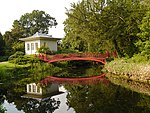 More images |
| Triumphal Arch at Shugborough Hall | Colwich | Triumphal Arch | c. 1765 | 17 March 1953 | SJ9866021589 52°47′31″N 2°01′17″W / 52.791868°N 2.021312°W / 52.791868; -2.021312 (Triumphal Arch at Shugborough Hall) | 1039140 | 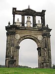 More images |
| Essex Bridge | Colwich | Bridge | 16th century | 10 January 1972 | SJ9951722564 52°48′02″N 2°00′31″W / 52.800634°N 2.008605°W / 52.800634; -2.008605 (Essex Bridge) | 1079635 | 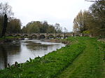 More images |
| Broughton Hall | Eccleshall | Country House | 1637 | 10 January 1953 | SJ7667333886 52°54′07″N 2°20′54″W / 52.901901°N 2.348241°W / 52.901901; -2.348241 (Broughton Hall) | 1189282 | 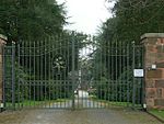 More images |
| Church of St Peter | Broughton, Eccleshall | Church | 17th century | 24 January 1967 | SJ7661233717 52°54′01″N 2°20′57″W / 52.900379°N 2.349136°W / 52.900379; -2.349136 (Church of St Peter) | 1039045 |  More images |
| Church of the Holy Trinity | Eccleshall | Church | 13th century | 24 January 1967 | SJ8275829179 52°51′35″N 2°15′27″W / 52.85982°N 2.257527°W / 52.85982; -2.257527 (Church of the Holy Trinity) | 1180335 |  More images |
| Church of St Lawrence | Gnosall | Church | 13th century | 15 January 1968 | SJ8301520889 52°47′07″N 2°15′12″W / 52.785306°N 2.253276°W / 52.785306; -2.253276 (Church of St Lawrence) | 1242645 |  More images |
| St Mary's Church | High Offley | Parish Church | 12th century | 15 January 1968 | SJ7835126161 52°49′57″N 2°19′22″W / 52.83253°N 2.322779°W / 52.83253; -2.322779 (St Mary's Church) | 1242831 |  More images |
| Church of St Mary | Ingestre | Church | 1676 | 15 January 1968 | SJ9766824692 52°49′11″N 2°02′10″W / 52.819758°N 2.036046°W / 52.819758; -2.036046 (Church of St Mary) | 1259814 |  More images |
| Church of St Peter | Norbury | Church | 18th century | 15 January 1968 | SJ7863323473 52°48′30″N 2°19′06″W / 52.808378°N 2.318417°W / 52.808378; -2.318417 (Church of St Peter) | 1242976 |  More images |
| Church of All Saints | Sandon | Church | Late 12th or early 13th century | 24 January 1967 | SJ9540929489 52°51′46″N 2°04′11″W / 52.862865°N 2.069635°W / 52.862865; -2.069635 (Church of All Saints) | 1294163 |  More images |
| Church of All Saints | Standon | Church | 14th century | 24 January 1967 | SJ8194934975 52°54′43″N 2°16′12″W / 52.911894°N 2.269866°W / 52.911894; -2.269866 (Church of All Saints) | 1039004 |  More images |
| Church of St Mary | Swynnerton | Church | 13th century | 24 January 1967 | SJ8522935503 52°55′00″N 2°13′16″W / 52.916742°N 2.221117°W / 52.916742; -2.221117 (Church of St Mary) | 1374205 |  More images |
| Swynnerton Hall | Swynnerton | House | c. 1725 | 10 January 1953 | SJ8521235444 52°54′58″N 2°13′17″W / 52.916211°N 2.221367°W / 52.916211; -2.221367 (Swynnerton Hall) | 1038991 |  More images |
| Tixall Gatehouse | Tixall | Gatehouse | c. 1575 | 15 January 1968 | SJ9791122948 52°48′15″N 2°01′57″W / 52.804082°N 2.032428°W / 52.804082; -2.032428 (Tixall Gatehouse) | 1258142 |  More images |
| Church of St Mary | Stafford | Church | Early 13th century | 16 January 1951 | SJ9213423190 52°48′22″N 2°07′05″W / 52.806203°N 2.118126°W / 52.806203; -2.118126 (Church of St Mary) | 1195365 |  More images |
Staffordshire Moorlands
| Name | Location | Type | Completed [note 1] | Date designated | Grid ref.[note 2] Geo-coordinates | Entry number [note 3] | Image |
|---|---|---|---|---|---|---|---|
| Church of St Peter | Alstonefield | Cross | 12th century | 1 February 1967 | SK1328055347 53°05′43″N 1°48′11″W / 53.095166°N 1.803139°W / 53.095166; -1.803139 (Church of St Peter) | 1038158 |  More images |
| Alton Castle | Alton | Castle | Late 12th century | 3 January 1967 | SK0725342455 52°58′46″N 1°53′36″W / 52.979394°N 1.893427°W / 52.979394; -1.893427 (Alton Castle) | 1374687 |  More images |
| Church of St Bartholomew | Blore | Parish Church | 13th century | 3 January 1967 | SK1373949324 53°02′28″N 1°47′48″W / 53.041014°N 1.79654°W / 53.041014; -1.79654 (Church of St Bartholomew) | 1191405 |  More images |
| Caverswall Castle, screen walls, gatehouse and bridge | Caverswall | Castle | 1615 | 2 May 1953 | SJ9508342808 52°58′57″N 2°04′29″W / 52.982591°N 2.074684°W / 52.982591; -2.074684 (Caverswall Castle, screen walls, gatehouse and bridge) | 1038000 |  More images |
| St. Giles' Catholic Church, Cheadle | Cheadle | Roman Catholic Church | 1841-6 | 3 January 1967 | SK0083643189 52°59′10″N 1°59′20″W / 52.986039°N 1.988996°W / 52.986039; -1.988996 (St. Giles' Catholic Church, Cheadle) | 1038008 | 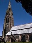 More images |
| St Mary's and All Saints' Church | Checkley | Parish Church | 12th century | 3 January 1967 | SK0279837889 52°56′18″N 1°57′35″W / 52.93839°N 1.959814°W / 52.93839; -1.959814 (St Mary's and All Saints' Church) | 1037959 |  More images |
| Church of the Holy Cross | Ilam Park, Ilam | Parish Church | 11th century | 1 February 1967 | SK1326950697 53°03′12″N 1°48′13″W / 53.053368°N 1.803493°W / 53.053368; -1.803493 (Church of the Holy Cross) | 1038155 |  More images |
| Cross shaft approximately 15 yards south of south porch of Church of the Holy Cross | Ilam Park, Ilam | Cross | 10th century | 1 February 1967 | SK1326250676 53°03′11″N 1°48′13″W / 53.053179°N 1.803599°W / 53.053179; -1.803599 (Cross shaft approximately 15 yards south of south porch of Church of the Holy Cross) | 1038113 |  More images |
| Cross shaft approximately 7 yards south of St Bertrams Chapel, Church of the Holy Cross | Ilam Park, Ilam | Cross | 10th century | 1 February 1967 | SK1327550681 53°03′12″N 1°48′12″W / 53.053224°N 1.803405°W / 53.053224; -1.803405 (Cross shaft approximately 7 yards south of St Bertrams Chapel, Church of the Holy Cross) | 1188671 | 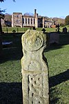 More images |
| Parish Church of All Saints | Leek | Parish Church | 1887 | 13 April 1951 | SJ9849956125 53°06′08″N 2°01′26″W / 53.10232°N 2.023871°W / 53.10232; -2.023871 (Parish Church of All Saints) | 1268538 |  More images |
Tamworth
| Name | Location | Type | Completed [note 1] | Date designated | Grid ref.[note 2] Geo-coordinates | Entry number [note 3] | Image |
|---|---|---|---|---|---|---|---|
| Causeway walls to north east of Tamworth Castle | Tamworth | Wall | Late 11th century | 11 May 1950 | SK2066703928 52°37′58″N 1°41′46″W / 52.632715°N 1.696073°W / 52.632715; -1.696073 (Causeway walls to north east of Tamworth Castle) | 1297334 |  |
| Church of St Editha | Tamworth | Church | Late 14th century | 11 May 1950 | SK2078404090 52°38′03″N 1°41′40″W / 52.634167°N 1.694334°W / 52.634167; -1.694334 (Church of St Editha) | 1207856 |  More images |
| Tamworth Castle | Tamworth | Castle | Late 11th century | 11 May 1950 | SK2061303913 52°37′57″N 1°41′49″W / 52.632582°N 1.696872°W / 52.632582; -1.696872 (Tamworth Castle) | 1197020 | 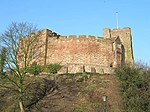 More images |
References
- National Heritage List for England
Notes
- ^ a b c d e f g h The date given is the date used by Historic England as significant for the initial building or that of an important part in the structure's description.
- ^ a b c d e f g h Sometimes known as OSGB36, the grid reference is based on the British national grid reference system used by the Ordnance Survey.
- ^ a b c d e f g h The "List Entry Number" is a unique number assigned to each listed building and scheduled monument by Historic England.
External links
![]() Media related to Grade I listed buildings in Staffordshire at Wikimedia Commons
Media related to Grade I listed buildings in Staffordshire at Wikimedia Commons
- v
- t
- e
- Bedfordshire
- Berkshire
- Bristol
- Buckinghamshire
- Cambridgeshire
- Cheshire
- Cornwall
- Cumbria
- Derbyshire
- Devon
- Dorset
- Durham
- East Sussex
- East Riding of Yorkshire
- Essex
- Gloucestershire
- Greater London
- Greater Manchester
- Hampshire
- Herefordshire
- Hertfordshire
- Isle of Wight
- Kent
- Lancashire
- Leicestershire
- Lincolnshire
- Merseyside
- Norfolk
- North Yorkshire
- Northamptonshire
- Northumberland
- Nottinghamshire
- Oxfordshire
- Rutland
- Shropshire
- Somerset
- South Yorkshire
- Staffordshire
- Suffolk
- Surrey
- Tyne and Wear
- Warwickshire
- West Midlands
- West Sussex
- West Yorkshire
- Wiltshire
- Worcestershire
- Babergh
- Bath and North East Somerset
- Bradford
- Brighton and Hove
- Broadland
- Cheltenham
- Cheshire East
- Cheshire West and Chester
- Cotswold
- Craven
- Dartford
- Dover
- Forest Heath
- Forest of Dean
- Ipswich
- Maidstone
- Mendip
- Mid Suffolk
- North Somerset
- Sedgemoor
- South Gloucestershire
- South Somerset
- St Edmundsbury
- Stroud
- Suffolk Coastal
- Taunton Deane
- Tewkesbury
- Waveney
- West Somerset
- Churches
- War memorials
- 20th century


