Grade I listed buildings in Mendip
Mendip is a local government district in the English county of Somerset. The Mendip district covers a largely rural area of 285 square miles (738 km2)[1] ranging from the Mendip Hills through on to the Somerset Levels. It has a population of approximately 11,000.[1] The administrative centre of the district is Shepton Mallet.
In the United Kingdom, the term listed building refers to a building or other structure officially designated as being of special architectural, historical or cultural significance; Grade I structures are those considered to be "buildings of exceptional interest".[2] Listing was begun by a provision in the Town and Country Planning Act 1947. Once listed, severe restrictions are imposed on the modifications allowed to a building's structure or its fittings. In England, the authority for listing under the Planning (Listed Buildings and Conservation Areas) Act 1990[3] rests with Historic England, a non-departmental public body sponsored by the Department for Digital, Culture, Media and Sport; local authorities have a responsibility to regulate and enforce the planning regulations.
There are 90 Grade I listed buildings in Mendip. Most are Norman- or medieval-era churches, many of which are included in the Somerset towers, a collection of distinctive, mostly spireless Gothic church towers. The greatest concentrations of Grade I listed buildings are in Wells and Glastonbury. In Wells these are clustered around the 10th-century Cathedral Church of St Andrew, better known as Wells Cathedral, and the 13th-century Bishop's Palace.[4] Glastonbury is the site of the Abbey, where construction started in the 7th century,[5] and its associated buildings. The ruined St Michael's church, damaged in an earthquake of 1275,[6] stands on Glastonbury Tor, where the site shows evidence of occupation from Neolithic times and the Dark Ages.[7] The Chalice Well has been in use since Pre-Christian times.[8] Glastonbury Abbey had a wider influence outside the town: tithe barns were built at Pilton[9] and West Bradley[10] to hold tithes, and a Fish House[11] was built at Meare along with a summer residence for the Abbot (now Manor Farmhouse[12]).
Medieval structures include Farleigh Hungerford Castle, fortified around 1370, and The George Inn at Norton St Philip, used as an army headquarters during the Monmouth Rebellion in 1685, and then as a courtroom to try the rebels in the Bloody Assizes.[13] Manor houses such as the 15th-century Seymours Court Farmhouse[14] at Beckington and The Old Manor at Croscombe. Mells Manor followed in the 16th century and in the 17th century Southill House[15] in Cranmore was built. Ston Easton Park[16] and Ammerdown House[17] in Kilmersdon were both completed in the 18th century. The most recent buildings included in the list are churches: the Church of St Peter at Hornblotton, built in 1872–74 by Sir Thomas Graham Jackson to replace a medieval church on the same site,[18] and Downside Abbey at Stratton-on-the-Fosse, more formally known as "The Basilica of St Gregory the Great at Downside", a Roman Catholic Benedictine monastery and the Senior House of the English Benedictine Congregation. The current buildings were started in the 19th century and are still unfinished.[19]
Map all coordinates using OpenStreetMap
Download coordinates as:
- KML
- GPX (all coordinates)
- GPX (primary coordinates)
- GPX (secondary coordinates)
Buildings
| Name | Location | Type | Completed [note 1] | Grid ref.[note 2] Geo-coordinates | Entry number [note 3] | Image | Ref. |
|---|---|---|---|---|---|---|---|
| 1 St Andrew Street | Wells | House | 1348, c. 1360 and 1424 | ST5516945949 51°12′40″N 2°38′35″W / 51.210976°N 2.643176°W / 51.210976; -2.643176 (1 St Andrew Street) | 1383102 |  More images | [20] |
| 1 – 13 Vicars Close | Wells | House | 1348, c. 1360 and 1424 | ST5514346023 51°12′42″N 2°38′37″W / 51.211639°N 2.643557°W / 51.211639; -2.643557 (1 – 13 Vicars Close) | 1383197 |  More images | [21] |
| 14 – 27 Vicars Close | Wells | House | 1348, c. 1360 and 1424 | ST5511546000 51°12′41″N 2°38′38″W / 51.21143°N 2.643955°W / 51.21143; -2.643955 (14 – 27 Vicars Close) | 1383199 |  More images | [22] |
| Abbey Church of St Gregory the Great, Downside Abbey | Stratton-on-the-Fosse | Church | 1872–82, c. 1890, 1901–1905, 1911–12, unfinished | ST6550950840 51°15′20″N 2°29′44″W / 51.255673°N 2.495629°W / 51.255673; -2.495629 (Abbey Church of St Gregory the Great, Downside Abbey) | 1058633 | 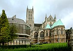 | [19]
|
| Abbey Tithe Barn, including attached wall to east | Glastonbury | Barn | 14th century | ST5036138551 51°08′39″N 2°42′40″W / 51.14406°N 2.710977°W / 51.14406; -2.710977 (Abbey Tithe Barn, including attached wall to east) | 1057953 |  More images | [23] |
| Abbot's Kitchen, Glastonbury Abbey | Glastonbury | Kitchen | pre Norman Conquest | ST4996938760 51°08′45″N 2°43′00″W / 51.145905°N 2.716609°W / 51.145905; -2.716609 (Abbot's Kitchen, Glastonbury Abbey) | 1172820 |  More images | [24] |
| Ammerdown House and stables. Now known as Ammerdown Study Centre | Kilmersdon | 1788 | ST7111552663 51°16′21″N 2°24′56″W / 51.272378°N 2.415447°W / 51.272378; -2.415447 (Ammerdown House and stables. Now known as Ammerdown Study Centre) | 1058685 |  Upload Photo | [17] | |
| Bishop Burnell's Great Hall | Wells | c. 1280 | ST5516845702 51°12′32″N 2°38′35″W / 51.208755°N 2.643159°W / 51.208755; -2.643159 (Bishop Burnell's Great Hall) | 1382875 | 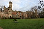 More images | [25] | |
| Boundary Walls to 1 – 13 Vicars Close | Wells | House | 1348, c. 1360 and 1424 | ST5513746009 51°12′41″N 2°38′37″W / 51.211513°N 2.643641°W / 51.211513; -2.643641 (Boundary Walls to 1 – 13 Vicars Close) | 1383198 |  More images | [26] |
| Boundary walls to 14 – 27 Vicars Close | Wells | House | 1348, c. 1360 and 1424 | ST5512546010 51°12′41″N 2°38′38″W / 51.211521°N 2.643813°W / 51.211521; -2.643813 (Boundary walls to 14 – 27 Vicars Close) | 1383200 |  More images | [27] |
| Brown's Gatehouse | Wells | Gateway | 1451 | ST5494445852 51°12′36″N 2°38′47″W / 51.210086°N 2.646384°W / 51.210086; -2.646384 (Brown's Gatehouse) | 1383101 | 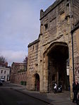 More images | [28]
|
| Cathedral Church of St Andrew and chapter house and cloisters | Wells | Cathedral | 1490 | ST5514845885 51°12′37″N 2°38′36″W / 51.210398°N 2.643468°W / 51.210398; -2.643468 (Cathedral Church of St Andrew and chapter house and cloisters) | 1382901 |  More images | [29]
|
| Chapel of St Leonard, perimeter wall and gateway, Farleigh Hungerford Castle | Farleigh Hungerford | Chapel | 14th century | ST8012457612 51°19′02″N 2°17′12″W / 51.317265°N 2.286583°W / 51.317265; -2.286583 (Chapel of St Leonard, perimeter wall and gateway, Farleigh Hungerford Castle) | 1345336 |  More images | [30] |
| Chapter House to Cathedral of St Andrew | Wells | Chapter House | 1307 | ST5516345912 51°12′38″N 2°38′36″W / 51.210642°N 2.643257°W / 51.210642; -2.643257 (Chapter House to Cathedral of St Andrew) | 1382900 | 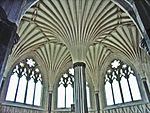 More images | [31] |
| Church of St Aldhelm | Doulting | Parish Church | 12th century | ST6461343131 51°11′11″N 2°30′28″W / 51.186303°N 2.507705°W / 51.186303; -2.507705 (Church of St Aldhelm) | 1217750 |  More images | [32] |
| Church of All Saints | East Pennard | Parish Church | 14th century | ST5970537458 51°08′06″N 2°34′38″W / 51.134968°N 2.577288°W / 51.134968; -2.577288 (Church of All Saints) | 1058488 |  More images | [33] |
| Church of All Saints | Lullington | Parish Church | c. 1280 | ST7832051941 51°15′58″N 2°18′44″W / 51.266207°N 2.312122°W / 51.266207; -2.312122 (Church of All Saints) | 1174267 |  More images | [34] |
| Church of All Saints | Nunney | Parish Church | 12th century | ST7376145696 51°12′35″N 2°22′37″W / 51.209861°N 2.377005°W / 51.209861; -2.377005 (Church of All Saints) | 1058297 |  More images | [35]
|
| Church of St Andrew | Mells | Parish Church | Late 15th century | ST7279049280 51°14′31″N 2°23′28″W / 51.242042°N 2.391178°W / 51.242042; -2.391178 (Church of St Andrew) | 1295876 | 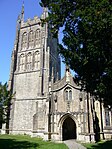 More images | [36]
|
| Church of St Bartholomew | Cranmore | Parish Church | 15th century | ST6682343333 51°11′18″N 2°28′34″W / 51.188252°N 2.476103°W / 51.188252; -2.476103 (Church of St Bartholomew) | 1058528 |  More images | [37] |
| Church of St Benedict | Glastonbury | Church | 15th century | ST4976038836 51°08′48″N 2°43′11″W / 51.146569°N 2.719607°W / 51.146569; -2.719607 (Church of St Benedict) | 1057966 |  More images | [38] |
| Church of St Cuthbert | Wells | Parish Church | 13th century | ST5466745658 51°12′30″N 2°39′01″W / 51.208319°N 2.650325°W / 51.208319; -2.650325 (Church of St Cuthbert) | 1383111 |  More images | [39]
|
| Church of St Dunstan | Baltonsborough | Parish Church | 15th century | ST5416234786 51°06′38″N 2°39′22″W / 51.110524°N 2.656165°W / 51.110524; -2.656165 (Church of St Dunstan) | 1345010 |  More images | [40] |
| Church of St George | Beckington | Parish Church | 14th century | ST8016951639 51°15′49″N 2°17′08″W / 51.263559°N 2.285604°W / 51.263559; -2.285604 (Church of St George) | 1345317 |  More images | [41] |
| Church of St Giles | Leigh-on-Mendip | Parish Church | c. 1350 | ST6924847278 51°13′26″N 2°26′30″W / 51.22386°N 2.441745°W / 51.22386; -2.441745 (Church of St Giles) | 1058345 |  More images | [42]
|
| Church of St James | Ashwick | Parish Church | 1450 | ST6371248419 51°14′02″N 2°31′16″W / 51.233793°N 2.521132°W / 51.233793; -2.521132 (Church of St James) | 1058471 | 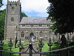 More images | [43]
|
| Church of St John the Baptist | Glastonbury | Parish Church | 15th century | ST5000239011 51°08′53″N 2°42′58″W / 51.148164°N 2.716172°W / 51.148164; -2.716172 (Church of St John the Baptist) | 1345459 | 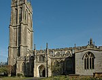 More images | [44] |
| Church of St John the Baptist | Pilton | Parish Church | 11th century | ST5885440816 51°09′54″N 2°35′23″W / 51.165101°N 2.589835°W / 51.165101; -2.589835 (Church of St John the Baptist) | 1058818 |  More images | [45] |
| Church of St Lawrence | Priddy | Parish Church | 13th century | ST5282851385 51°15′35″N 2°40′39″W / 51.259663°N 2.677404°W / 51.259663; -2.677404 (Church of St Lawrence) | 1177825 |  More images | [46] |
| Church of St Lawrence | Rode | Parish Church | Late 14th century | ST8080853384 51°16′45″N 2°16′36″W / 51.279272°N 2.27654°W / 51.279272; -2.27654 (Church of St Lawrence) | 1345357 |  More images | [47]
|
| Church of St Leonard | Marston Bigot | Parish Church | 1789 | ST7554944977 51°12′13″N 2°21′05″W / 51.203476°N 2.35136°W / 51.203476; -2.35136 (Church of St Leonard) | 1058276 |  More images | [48] |
| Church of St Leonard | Rodney Stoke | Parish Church | 12th century | ST4822449851 51°14′44″N 2°44′35″W / 51.24547°N 2.743156°W / 51.24547; -2.743156 (Church of St Leonard) | 1058592 |  More images | [49]
|
| Church of St Margaret | Babington | Parish Church | 1748 | ST7048951031 51°15′28″N 2°25′27″W / 51.257671°N 2.424285°W / 51.257671; -2.424285 (Church of St Margaret) | 1177624 |  More images | [50] |
| Church of St Mary | Hardington | Parish Church | 11th century | ST7423052559 51°16′18″N 2°22′15″W / 51.271593°N 2.370787°W / 51.271593; -2.370787 (Church of St Mary) | 1058710 |  More images | [51] |
| Church of St Mary | Litton | Parish Church | 13th century | ST5938254702 51°17′24″N 2°35′02″W / 51.289993°N 2.583863°W / 51.289993; -2.583863 (Church of St Mary) | 1345127 | 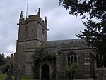 More images | [52] |
| Church of St Mary | Hemington | Parish Church | 12th century | ST7273653023 51°16′33″N 2°23′32″W / 51.275695°N 2.392238°W / 51.275695; -2.392238 (Church of St Mary) | 1058711 |  More images | [53] |
| Church of St Mary | Meare | Parish Church | 1323 | ST4553841707 51°10′19″N 2°46′49″W / 51.171996°N 2.780394°W / 51.171996; -2.780394 (Church of St Mary) | 1058750 |  More images | [54] |
| Church of St Mary | Witham Friary | Parish Church | c. 1200 | ST7440341097 51°10′07″N 2°22′03″W / 51.168538°N 2.367486°W / 51.168538; -2.367486 (Church of St Mary) | 1058224 |  More images | [55]
|
| Church of St Mary, causeway bridge and gates | Orchardlea | Parish Church | 13th century | ST7735550991 51°15′27″N 2°19′33″W / 51.257627°N 2.325893°W / 51.257627; -2.325893 (Church of St Mary, causeway bridge and gates) | 1058142 | 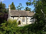 More images | [56] |
| Church of St Mary Magdalene | Chewton Mendip | Parish Church | 12th | ST5963853153 51°16′34″N 2°34′48″W / 51.276084°N 2.580016°W / 51.276084; -2.580016 (Church of St Mary Magdalene) | 1345137 |  More images | [57] |
| Church of St Mary Magdalene | Ditcheat | Parish Church | 12th century | ST6256936329 51°07′30″N 2°32′10″W / 51.125011°N 2.536239°W / 51.125011; -2.536239 (Church of St Mary Magdalene) | 1345167 | 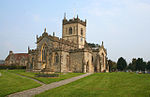 More images | [58] |
| Church of St Mary Magdalene | Great Elm | Parish Church | 12th century | ST7463849325 51°14′33″N 2°21′53″W / 51.242532°N 2.364709°W / 51.242532; -2.364709 (Church of St Mary Magdalene) | 1295880 | 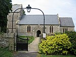 More images | [59]
|
| Church of St Mary the Virgin | Batcombe | Parish Church | 15th century | ST6901339030 51°08′59″N 2°26′40″W / 51.149684°N 2.444396°W / 51.149684; -2.444396 (Church of St Mary the Virgin) | 1234822 | 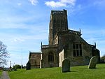 More images | [60]
|
| Church of St Mary the Virgin | Croscombe | Parish Church | 15th century | ST5906144421 51°11′51″N 2°35′14″W / 51.19753°N 2.587287°W / 51.19753; -2.587287 (Church of St Mary the Virgin) | 1174682 |  More images | [61] |
| Church of St Matthew | Wookey | Parish Church | 12th century | ST5185145791 51°12′33″N 2°41′26″W / 51.209284°N 2.690651°W / 51.209284; -2.690651 (Church of St Matthew) | 1295105 |  More images | [62]
|
| Church of St Michael | Buckland Dinham | Parish Church | c. 1200 | ST7550051264 51°15′36″N 2°21′09″W / 51.260005°N 2.352494°W / 51.260005; -2.352494 (Church of St Michael) | 1345316 |  More images | [63] |
| Church of St Nicholas | West Pennard | Parish Church | 15th century | ST5521938263 51°08′31″N 2°38′29″W / 51.141872°N 2.6415°W / 51.141872; -2.6415 (Church of St Nicholas) | 1345049 | 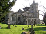 More images | [64]
|
| Church of St Peter | Evercreech | Parish Church | 14th century | ST6493738679 51°08′47″N 2°30′09″W / 51.146292°N 2.502633°W / 51.146292; -2.502633 (Church of St Peter) | 1059172 |  More images | [65] |
| Church of St Peter | Hornblotton | Parish Church | 1874 | ST5914934151 51°06′19″N 2°35′05″W / 51.105193°N 2.584859°W / 51.105193; -2.584859 (Church of St Peter) | 1058789 | 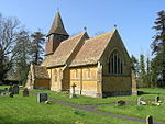 More images | [18] |
| Church of St Peter and St Paul | Kilmersdon | Parish Church | 15th century | ST6959352423 51°16′13″N 2°26′14″W / 51.27014°N 2.437244°W / 51.27014; -2.437244 (Church of St Peter and St Paul) | 1307311 |  More images | [66] |
| Church of St Peter and St Paul | Shepton Mallet | Parish Church | 12th century | ST6197743670 51°11′28″N 2°32′44″W / 51.190979°N 2.545476°W / 51.190979; -2.545476 (Church of St Peter and St Paul) | 1345202 |  More images | [67] |
| Church of the Holy Trinity | Street | Parish Church | 14th century | ST4883437168 51°07′53″N 2°43′57″W / 51.13149°N 2.732607°W / 51.13149; -2.732607 (Church of the Holy Trinity) | 1058753 | 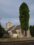 More images | [68] |
| Church of the Holy Trinity | Whatley | Parish Church | 1846 | ST7192247020 51°13′18″N 2°24′12″W / 51.221679°N 2.403435°W / 51.221679; -2.403435 (Church of the Holy Trinity) | 1345303 |  More images | [69]
|
| Church of St Vigor | Stratton-on-the-Fosse | Parish Church | 12th century | ST6592750779 51°15′19″N 2°29′23″W / 51.25515°N 2.489634°W / 51.25515; -2.489634 (Church of St Vigor) | 1345110 | 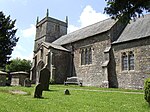 More images | [70]
|
| Churchyard cross in churchyard south of porch Church of St Mary Magdalene | Chewton Mendip | Parish Church | 15th century | ST5963853153 51°16′34″N 2°34′48″W / 51.276084°N 2.580016°W / 51.276084; -2.580016 (Churchyard cross in churchyard south of porch Church of St Mary Magdalene) | 1345137 |  More images | [71] |
| Churchyard cross in the churchyard about 9 metres south of south aisle, Church of St Nicholas | West Pennard | Churchyard cross | 15th century | ST5522838251 51°08′30″N 2°38′29″W / 51.141764°N 2.64137°W / 51.141764; -2.64137 (Churchyard cross in the churchyard about 9 metres south of south aisle, Church of St Nicholas) | 1175863 | 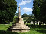 More images | [72] |
| Cloisters to Cathedral Church of St Andrew | Wells | Cloisters | 13th century | ST5511645814 51°12′35″N 2°38′38″W / 51.209758°N 2.643917°W / 51.209758; -2.643917 (Cloisters to Cathedral Church of St Andrew) | 1382902 | 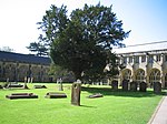 More images | [73] |
| Court Barn | West Bradley | Early 15th century | ST5469537037 51°07′51″N 2°38′56″W / 51.130807°N 2.648835°W / 51.130807; -2.648835 (Court Barn) | 1175792 |  More images | [10]
| |
| Farleigh Hungerford Castle | Farleigh Hungerford | Castle | 14th century | ST8007957661 51°19′04″N 2°17′14″W / 51.317704°N 2.287232°W / 51.317704; -2.287232 (Farleigh Hungerford Castle) | 1058117 | 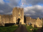 More images | [74] |
| Former Rook Lane Congregational Chapel | Frome | 1707 | ST7753347870 51°13′46″N 2°19′23″W / 51.229571°N 2.323145°W / 51.229571; -2.323145 (Former Rook Lane Congregational Chapel) | 1167729 |  More images | [75] | |
| Former Tithe Barn in farmyard at Cumhill Farm | Pilton | 14th century | ST5890140630 51°09′48″N 2°35′21″W / 51.163432°N 2.589142°W / 51.163432; -2.589142 (Former Tithe Barn in farmyard at Cumhill Farm) | 1058842 |  More images | [9] | |
| Gatehouse and boundary wall with bridge over moat | Wells | c. 1341 | ST5519045631 51°12′29″N 2°38′34″W / 51.208118°N 2.642835°W / 51.208118; -2.642835 (Gatehouse and boundary wall with bridge over moat) | 1382876 | 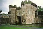 More images | [76]
| |
| Gatehouse to west of Manor Farmhouse | Whatley | Gatehouse | c. 1500 | ST7337347611 51°13′37″N 2°22′58″W / 51.227062°N 2.382702°W / 51.227062; -2.382702 (Gatehouse to west of Manor Farmhouse) | 1175158 | 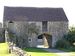 More images | [77] |
| George Hotel and Pilgrims' Inn | Glastonbury | Late 15th century | ST4988738964 51°08′52″N 2°43′04″W / 51.147732°N 2.71781°W / 51.147732; -2.71781 (George Hotel and Pilgrims' Inn) | 1345455 | 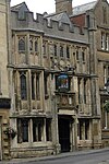 More images | [78] | |
| Glastonbury Abbey | Glastonbury | pre Norman Conquest | ST5005838781 51°08′46″N 2°42′55″W / 51.146101°N 2.71534°W / 51.146101; -2.71534 (Glastonbury Abbey) | 1345447 |  More images | [5]
| |
| Manor Farmhouse with attached range of outbuildings | Meare | Farmhouse | 14th century | ST4556241744 51°10′20″N 2°46′48″W / 51.172331°N 2.780057°W / 51.172331; -2.780057 (Manor Farmhouse with attached range of outbuildings) | 1175936 |  More images | [12] |
| Mells Manor and garden walls to rear | Mells | 16th century | ST7272749280 51°14′31″N 2°23′31″W / 51.242039°N 2.392081°W / 51.242039; -2.392081 (Mells Manor and garden walls to rear) | 1058351 |  More images | [79] | |
| Penniless Porch | Wells | Gateway | c. 1450 | ST5505945811 51°12′35″N 2°38′41″W / 51.209726°N 2.644733°W / 51.209726; -2.644733 (Penniless Porch) | 1383024 |  More images | [80]
|
| Seymours Court Farmhouse | Beckington | Farmhouse | 15th century | ST8116752707 51°16′24″N 2°16′17″W / 51.273196°N 2.271357°W / 51.273196; -2.271357 (Seymours Court Farmhouse) | 1058220 |  More images | [14] |
| Southill House and outbuildings | Cranmore | 18th century | ST6716542627 51°10′55″N 2°28′16″W / 51.181924°N 2.471145°W / 51.181924; -2.471145 (Southill House and outbuildings) | 1058567 |  More images | [81] | |
| St John's Priory with front boundary wall and railings | Wells | Former Priory | 14th century | ST5479545526 51°12′26″N 2°38′55″W / 51.207143°N 2.648476°W / 51.207143; -2.648476 (St John's Priory with front boundary wall and railings) | 1383115 |  More images | [82]
|
| St Michaels church tower, Tor Hill | Glastonbury Tor | 13th century | ST5121838615 51°08′41″N 2°41′55″W / 51.144709°N 2.698735°W / 51.144709; -2.698735 (St Michaels church tower, Tor Hill) | 1345475 |  More images | [83] | |
| Ston Easton Park | Ston Easton | c. 1769 | ST6252054080 51°17′05″N 2°32′20″W / 51.284616°N 2.538799°W / 51.284616; -2.538799 (Ston Easton Park) | 1345108 |  More images | [16]
| |
| The Abbot's Fish House | Meare | 14th century | ST4580441729 51°10′20″N 2°46′36″W / 51.172219°N 2.776593°W / 51.172219; -2.776593 (The Abbot's Fish House) | 1345067 |  More images | [11] | |
| The Bishop's Barn | Wells | Barn | 15th century | ST5509045532 51°12′26″N 2°38′39″W / 51.20722°N 2.644254°W / 51.20722; -2.644254 (The Bishop's Barn) | 1383158 |  More images | [84] |
| The Bishop's Chapel and the Bishop's Palace | Wells | Bishop's Palace and House | c. 1290 | ST5520845734 51°12′33″N 2°38′33″W / 51.209046°N 2.642591°W / 51.209046; -2.642591 (The Bishop's Chapel and the Bishop's Palace) | 1382874 |  More images | [85] |
| The Bishop's Eye | Wells | Gateway | c. 1451 | ST5506445788 51°12′34″N 2°38′41″W / 51.20952°N 2.644659°W / 51.20952; -2.644659 (The Bishop's Eye) | 1383026 |  More images | [86]
|
| The Bishop's Palace and Bishop's House | Wells | Bishop's Palace and House | c. 1230 | ST5520745781 51°12′34″N 2°38′33″W / 51.209468°N 2.642611°W / 51.209468; -2.642611 (The Bishop's Palace and Bishop's House) | 1382873 | More images | [4]
|
| The Blue House | Frome | 1726 | ST7774448109 51°13′54″N 2°19′12″W / 51.231728°N 2.320138°W / 51.231728; -2.320138 (The Blue House) | 1345500 |  More images | [87] | |
| The Chain Gate with approach staircase | Wells | Gateway | c. 1460 | ST5515245930 51°12′39″N 2°38′36″W / 51.210803°N 2.643417°W / 51.210803; -2.643417 (The Chain Gate with approach staircase) | 1382904 |  More images | [88] |
| The Chalice Well | Glastonbury | Pre-Christian | ST5065638508 51°08′37″N 2°42′24″W / 51.143698°N 2.706754°W / 51.143698; -2.706754 (The Chalice Well) | 1167594 |  More images | [8] | |
| The Gatehouse | Baltonsborough | House | 16th century | ST5363734712 51°06′35″N 2°39′49″W / 51.109817°N 2.663654°W / 51.109817; -2.663654 (The Gatehouse) | 1345035 | 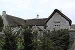 More images | [89] |
| The George Inn | Norton St Philip | Inn | 14th century | ST7741055886 51°18′06″N 2°19′31″W / 51.301644°N 2.325416°W / 51.301644; -2.325416 (The George Inn) | 1174953 | 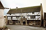 More images | [90] |
| The Old Deanery | Wells | Former Deanery | 12th century | ST5500045919 51°12′38″N 2°38′44″W / 51.210693°N 2.645591°W / 51.210693; -2.645591 (The Old Deanery) | 1382906 |  More images | [91] |
| Old Deanery Court with link wall along east side | Wells | Former Deanery | 12th century | ST5502545948 51°12′39″N 2°38′43″W / 51.210955°N 2.645237°W / 51.210955; -2.645237 (Old Deanery Court with link wall along east side) | 1382907 |  More images | [92] |
| Gatehouse and south boundary wall to the Old Deanery | Wells | Gatehouse | 12th century | ST5503545920 51°12′39″N 2°38′42″W / 51.210704°N 2.64509°W / 51.210704; -2.64509 (Gatehouse and south boundary wall to the Old Deanery) | 1382908 |  More images | [93] |
| The Old Manor | Croscombe | Manor House | c. 1460 | ST5927644317 51°11′48″N 2°35′03″W / 51.19661°N 2.584198°W / 51.19661; -2.584198 (The Old Manor) | 1174843 |  More images | [15] |
| The Tribunal | Glastonbury | 15th century | ST4993438961 51°08′52″N 2°43′02″W / 51.147709°N 2.717137°W / 51.147709; -2.717137 (The Tribunal) | 1345457 |  More images | [94] | |
| The Vicars' Chapel | Wells | Private chapel | c. 1430 | ST5510946076 51°12′44″N 2°38′39″W / 51.212113°N 2.644051°W / 51.212113; -2.644051 (The Vicars' Chapel) | 1383201 |  More images | [95] |
| The Vicars' Hall including number 28 | Wells | Assembly and dining hall for the Vicars Choral | 1348 | ST5514845942 51°12′39″N 2°38′37″W / 51.210911°N 2.643475°W / 51.210911; -2.643475 (The Vicars' Hall including number 28) | 1383202 |  More images | [96] |
| The well house about 35 metres north of Bishop's Palace | Wells | c. 1451 | ST5522745824 51°12′35″N 2°38′32″W / 51.209856°N 2.64233°W / 51.209856; -2.64233 (The well house about 35 metres north of Bishop's Palace) | 1382877 |  More images | [97] | |
| Tithe Barn in farmyard at Manor Farm | Doulting | 15th century | ST6472443023 51°11′07″N 2°30′22″W / 51.185338°N 2.506106°W / 51.185338; -2.506106 (Tithe Barn in farmyard at Manor Farm) | 1221353 |  More images | [98] |
See also
Notes
- ^ The date given is the date used by Historic England as significant for the initial building or that of an important part in the structure's description.
- ^ Sometimes known as OSGB36, the grid reference is based on the British national grid reference system used by the Ordnance Survey.
- ^ The "List Entry Number" is a unique number assigned to each listed building and scheduled monument by Historic England.
References
- ^ a b "A Portrait of Mendip". Mendip District Council. Archived from the original on 4 January 2014. Retrieved 21 October 2017.
- ^ "Listed Buildings". Historic England. Archived from the original on 19 March 2017. Retrieved 23 August 2017.
- ^ "Planning (Listed Buildings and Conservation Areas) Act 1990 (c. 9)". Ministry of Justice. Archived from the original on 18 April 2010. Retrieved 17 December 2007.
- ^ a b Historic England. "The Bishop's Palace and Bishop's House (1382873)". National Heritage List for England. Retrieved 7 July 2015.
- ^ a b Historic England. "Glastonbury Abbey (1345447)". National Heritage List for England. Retrieved 3 April 2015.
- ^ "Historical Earthquake Listing". British Geological Survey. Archived from the original on 19 November 2007. Retrieved 25 December 2007.
- ^ "The Glastonbury Tor Maze". About Glastonbury Tor. Archived from the original on 13 October 2007. Retrieved 25 December 2007.
- ^ a b Historic England. "The Chalice Well (1167594)". National Heritage List for England. Retrieved 3 April 2015.
- ^ a b Historic England. "Former Tithe Barn in farmyard at Cumhill Farm (1058842)". National Heritage List for England. Retrieved 3 April 2015.
- ^ a b Historic England. "Court Barn (1175792)". National Heritage List for England. Retrieved 3 April 2015.
- ^ a b Historic England. "The Abbot's Fish House (1345067)". National Heritage List for England. Retrieved 7 July 2015.
- ^ a b Historic England. "Manor Farmhouse with attached range of outbuildings (1175936)". National Heritage List for England. Retrieved 3 April 2015.
- ^ "History". The George Inn. Archived from the original on 29 August 2009. Retrieved 20 May 2009.
- ^ a b Historic England. "Seymours Court Farmhouse (1058220)". National Heritage List for England. Retrieved 3 April 2015.
- ^ a b Historic England. "The Old Manor (1174843)". National Heritage List for England. Retrieved 3 April 2015.
- ^ a b Historic England. "Ston Easton Park (1345108)". National Heritage List for England. Retrieved 3 April 2015.
- ^ a b Historic England. "Ammerdown House and stables. Now known as Ammerdown Study Centre (1058685)". National Heritage List for England. Retrieved 3 April 2015.
- ^ a b Historic England. "Church of St Peter (1058789)". National Heritage List for England. Retrieved 3 April 2015.
- ^ a b Historic England. "Abbey Church of St Gregory the Great, Downside Abbey (1058633)". National Heritage List for England. Retrieved 3 April 2015.
- ^ Historic England. "1 St Andrew Street (1383102)". National Heritage List for England. Retrieved 3 April 2015.
- ^ Historic England. "1 – 13 Vicars Close (1383197)". National Heritage List for England. Retrieved 3 April 2015.
- ^ Historic England. "14 – 27 Vicars Close (1383199)". National Heritage List for England. Retrieved 3 April 2015.
- ^ Historic England. "Abbey Tithe Barn, including attached wall to east (1057953)". National Heritage List for England. Retrieved 3 April 2015.
- ^ Historic England. "Abbot's Kitchen, Glastonbury Abbey (1172820)". National Heritage List for England. Retrieved 7 July 2015.
- ^ Historic England. "Bishop Burnell's Great Hall (1382875)". National Heritage List for England. Retrieved 7 July 2015.
- ^ Historic England. "Boundary Walls to 1 – 13 Vicars Close (1383198)". National Heritage List for England. Retrieved 3 April 2015.
- ^ Historic England. "Boundary walls to 14 – 27 Vicars Close (1383200)". National Heritage List for England. Retrieved 3 April 2015.
- ^ Historic England. "Brown's Gatehouse (1383101)". National Heritage List for England. Retrieved 7 July 2015.
- ^ Historic England. "Cathedral Church of St Andrew and chapter house and cloisters (1382901)". National Heritage List for England. Retrieved 3 April 2015.
- ^ Historic England. "Chapel of St Leonard, perimeter wall and gateway, Farleigh Hungerford Castle (1345336)". National Heritage List for England. Retrieved 3 April 2015.
- ^ Historic England. "Chapter House to Cathedral of St Andrew (1382900)". National Heritage List for England. Retrieved 3 April 2015.
- ^ Historic England. "Church of St Aldhelm (1217750)". National Heritage List for England. Retrieved 3 April 2015.
- ^ Historic England. "Church of All Saints (1058488)". National Heritage List for England. Retrieved 3 April 2015.
- ^ Historic England. "Church of All Saints (1174267)". National Heritage List for England. Retrieved 3 April 2015.
- ^ Historic England. "Church of All Saints (1058297)". National Heritage List for England. Retrieved 3 April 2015.
- ^ Historic England. "Church of St Andrew (1295876)". National Heritage List for England. Retrieved 3 April 2015.
- ^ Historic England. "Church of St Bartholomew (1058528)". National Heritage List for England. Retrieved 3 April 2015.
- ^ Historic England. "Church of St Benedict (1057966)". National Heritage List for England. Retrieved 3 April 2015.
- ^ Historic England. "Church of St Cuthbert (1383111)". National Heritage List for England. Retrieved 3 April 2015.
- ^ Historic England. "Church of St Dunstan (1345010)". National Heritage List for England. Retrieved 3 April 2015.
- ^ Historic England. "Church of St George (1345317)". National Heritage List for England. Retrieved 3 April 2015.
- ^ Historic England. "Church of St Giles (1058345)". National Heritage List for England. Retrieved 3 April 2015.
- ^ Historic England. "Church of St James (1058471)". National Heritage List for England. Retrieved 3 April 2015.
- ^ Historic England. "Church of St John the Baptist (1345459)". National Heritage List for England. Retrieved 3 April 2015.
- ^ Historic England. "Church of St John the Baptist (1058818)". National Heritage List for England. Retrieved 3 April 2015.
- ^ Historic England. "Church of St Lawrence (1177825)". National Heritage List for England. Retrieved 3 April 2015.
- ^ Historic England. "Church of St Lawrence (1345357)". National Heritage List for England. Retrieved 3 April 2015.
- ^ Historic England. "Church of St Leonard (1058276)". National Heritage List for England. Retrieved 3 April 2015.
- ^ Historic England. "Church of St Leonard (1058592)". National Heritage List for England. Retrieved 3 April 2015.
- ^ Historic England. "Church of St Margaret (1177624)". National Heritage List for England. Retrieved 3 April 2015.
- ^ Historic England. "Church of St Mary (1058710)". National Heritage List for England. Retrieved 3 April 2015.
- ^ Historic England. "Church of St Mary (1345127)". National Heritage List for England. Retrieved 3 April 2015.
- ^ Historic England. "Church of St Mary (1058711)". National Heritage List for England. Retrieved 3 April 2015.
- ^ Historic England. "Church of St Mary (1058750)". National Heritage List for England. Retrieved 3 April 2015.
- ^ Historic England. "Church of St Mary (1058224)". National Heritage List for England. Retrieved 3 April 2015.
- ^ Historic England. "Church of St Mary, causeway bridge and gates (1058142)". National Heritage List for England. Retrieved 3 April 2015.
- ^ Historic England. "Church of St Mary Magdalene (1345137)". National Heritage List for England. Retrieved 3 April 2015.
- ^ Historic England. "Church of St Mary Magdalene (1345167)". National Heritage List for England. Retrieved 3 April 2015.
- ^ Historic England. "Church of St Mary Magdalene (1295880)". National Heritage List for England. Retrieved 3 April 2015.
- ^ Historic England. "Church of St Mary the Virgin (1234822)". National Heritage List for England. Retrieved 3 April 2015.
- ^ Historic England. "Church of St Mary the Virgin (1174682)". National Heritage List for England. Retrieved 3 April 2015.
- ^ Historic England. "Church of St Matthew (1295105)". National Heritage List for England. Retrieved 3 April 2015.
- ^ Historic England. "Church of St Michael (1345316)". National Heritage List for England. Retrieved 3 April 2015.
- ^ Historic England. "Church of St Nicholas (1345049)". National Heritage List for England. Retrieved 3 April 2015.
- ^ Historic England. "Church of St Peter (1059172)". National Heritage List for England. Retrieved 3 April 2015.
- ^ Historic England. "Church of St Peter and St Paul (1307311)". National Heritage List for England. Retrieved 3 April 2015.
- ^ Historic England. "Church of St Peter and St Paul (1345202)". National Heritage List for England. Retrieved 3 April 2015.
- ^ Historic England. "Church of the Holy Trinity (1058753)". National Heritage List for England. Retrieved 3 April 2015.
- ^ Historic England. "Church of the Holy Trinity (1345303)". National Heritage List for England. Retrieved 3 April 2015.
- ^ Historic England. "Church of St Vigor (1345110)". National Heritage List for England. Retrieved 3 April 2015.
- ^ Historic England. "Churchyard cross in churchyard south of porch Church of St Mary Magdalene (1177454)". National Heritage List for England. Retrieved 3 April 2015.
- ^ Historic England. "Churchyard cross in the churchyard about 9 metres south of south aisle, Church of St Nicholas (1175863)". National Heritage List for England. Retrieved 3 April 2015.
- ^ Historic England. "Cloisters to Cathedral Church of St Andrew (1382902)". National Heritage List for England. Retrieved 3 April 2015.
- ^ Historic England. "Farleigh Hungerford Castle (1058117)". National Heritage List for England. Retrieved 3 April 2015.
- ^ Historic England. "Former Rook Lane Congregational Chapel (1167729)". National Heritage List for England. Retrieved 3 April 2015.
- ^ Historic England. "Gatehouse and boundary wall with bridge over moat (1382876)". National Heritage List for England. Retrieved 3 April 2015.
- ^ Historic England. "Gatehouse to west of Manor Farmhouse (1175158)". National Heritage List for England. Retrieved 3 April 2015.
- ^ Historic England. "George Hotel and Pilgrims' Inn (1345455)". National Heritage List for England. Retrieved 7 July 2015.
- ^ Historic England. "Mells Manor and garden walls to rear (1058351)". National Heritage List for England. Retrieved 3 April 2015.
- ^ Historic England. "Penniless Porch (1383024)". National Heritage List for England. Retrieved 3 April 2015.
- ^ Historic England. "Southill House and outbuildings (1058567)". National Heritage List for England. Retrieved 3 April 2015.
- ^ Historic England. "St John's Priory with front boundary wall and railings (1383115)". National Heritage List for England. Retrieved 7 July 2015.
- ^ Historic England. "St Michaels church tower, Tor Hill (1345475)". National Heritage List for England. Retrieved 3 April 2015.
- ^ Historic England. "The Bishop's Barn (1383158)". National Heritage List for England. Retrieved 7 July 2015.
- ^ Historic England. "The Bishop's Chapel and the Bishop's Palace (1382874)". National Heritage List for England. Retrieved 7 July 2015.
- ^ Historic England. "The Bishop's Eye (1383026)". National Heritage List for England. Retrieved 7 July 2015.
- ^ Historic England. "The Blue House (1345500)". National Heritage List for England. Retrieved 3 April 2015.
- ^ Historic England. "The chain gate with approach staircase (1382904)". National Heritage List for England. Retrieved 3 April 2015.
- ^ Historic England. "The Gatehouse (1345035)". National Heritage List for England. Retrieved 3 April 2015.
- ^ Historic England. "The George Inn (1174953)". National Heritage List for England. Retrieved 3 April 2015.
- ^ Historic England. "The Old Deanery (1382906)". National Heritage List for England. Retrieved 3 April 2015.
- ^ Historic England. "Old Deanery Court with link wall along east side (1382907)". National Heritage List for England. Retrieved 3 April 2015.
- ^ Historic England. "Gatehouse and south boundary wall to the Old Deanery (1382908)". National Heritage List for England. Retrieved 3 April 2015.
- ^ Historic England. "The Tribunal (1345457)". National Heritage List for England. Retrieved 3 April 2015.
- ^ Historic England. "The Vicars' Chapel (1383201)". National Heritage List for England. Retrieved 7 July 2015.
- ^ Historic England. "The Vicars' Hall including number 28 (1383202)". National Heritage List for England. Retrieved 7 July 2015.
- ^ Historic England. "The well house about 35 metres north of Bishop's Palace (1382877)". National Heritage List for England. Retrieved 7 July 2015.
- ^ Historic England. "Tithe Barn in farmyard at Manor Farm (1221353)". National Heritage List for England. Retrieved 3 April 2015.
External links
- Listed building section at Mendip District Council
- v
- t
- e


