Grade I listed buildings in Gloucester

Map all coordinates using OpenStreetMap
Download coordinates as:
- KML
- GPX (all coordinates)
- GPX (primary coordinates)
- GPX (secondary coordinates)
There are over 9,000 Grade I listed buildings in England. This page is a list of these buildings in the district of Gloucester in Gloucestershire.
Gloucester
| Name | Location | Type | Completed [note 1] | Date designated | Grid ref.[note 2] Geo-coordinates | Entry number [note 3] | Image |
|---|---|---|---|---|---|---|---|
| Blackfriars Church and Part of East Range of Friary | Gloucester | House | 1540–1545 | 23 January 1952 | SO8297518427 51°51′51″N 2°14′55″W / 51.86416°N 2.248646°W / 51.86416; -2.248646 (Blackfriars Church and Part of East Range of Friary) | 1245989 | 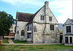 More images |
| North End of West Range, Blackfriars | 11 Blackfriars, Gloucester | House | 1540–1545 | 23 January 1952 | SO8294618433 51°51′51″N 2°14′57″W / 51.864213°N 2.249067°W / 51.864213; -2.249067 (North End of West Range, Blackfriars) | 1245991 |  More images |
| South Range and adjoining South End of West Range, Blackfriars | Gloucester | House | Later alterations | 23 January 1952 | SO8294118407 51°51′50″N 2°14′57″W / 51.863979°N 2.249139°W / 51.863979; -2.249139 (South Range and adjoining South End of West Range, Blackfriars) | 1245992 |  More images |
| Cathedral Chapter House | Gloucester | Chapter House | c. 1100 | 23 January 1952 | SO8313518814 51°52′04″N 2°14′47″W / 51.867645°N 2.246341°W / 51.867645; -2.246341 (Cathedral Chapter House) | 1245953 |  More images |
| Cathedral Church of the Holy and Indivisible Trinity | Gloucester | Abbey | 1089–1100 | 23 January 1952 | SO8312118778 51°52′02″N 2°14′48″W / 51.86732°N 2.246543°W / 51.86732; -2.246543 (Cathedral Church of the Holy and Indivisible Trinity) | 1245952 | 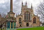 More images |
| Cathedral Cloister and Lavatorium | Gloucester | Abbey | c. 1360 | 23 January 1952 | SO8310418842 51°52′04″N 2°14′48″W / 51.867895°N 2.246793°W / 51.867895; -2.246793 (Cathedral Cloister and Lavatorium) | 1245954 |  More images |
| Cathedral Treasury, Vestry and Library | Gloucester | Abbey | c. 1100 | 23 January 1952 | SO8313318803 51°52′03″N 2°14′47″W / 51.867546°N 2.24637°W / 51.867546; -2.24637 (Cathedral Treasury, Vestry and Library) | 1245956 |  More images |
| Church House | Gloucester | Abbey | Early to Mid 12th century | 23 January 1952 | SO8306318828 51°52′04″N 2°14′51″W / 51.867768°N 2.247388°W / 51.867768; -2.247388 (Church House) | 1245900 |  More images |
| Church of St Mary De Crypt | Gloucester | Parish Church | c. 1140 | 23 January 1952 | SO8308118419 51°51′51″N 2°14′50″W / 51.864092°N 2.247106°W / 51.864092; -2.247106 (Church of St Mary De Crypt) | 1245611 |  More images |
| Church of St Mary De Lode | Gloucester | Church Hall | 1980 | 23 January 1952 | SO8294118910 51°52′07″N 2°14′57″W / 51.868502°N 2.249164°W / 51.868502; -2.249164 (Church of St Mary De Lode) | 1245668 |  More images |
| Church of St Nicholas | Gloucester | Church | 1993–1994 | 23 January 1952 | SO8290118778 51°52′02″N 2°14′59″W / 51.867314°N 2.249738°W / 51.867314; -2.249738 (Church of St Nicholas) | 1245083 | 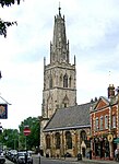 More images |
| Dick Whittington Tavern | Gloucester | House | Late 19th century | 23 January 1952 | SO8292418765 51°52′02″N 2°14′58″W / 51.867198°N 2.249403°W / 51.867198; -2.249403 (Dick Whittington Tavern) | 1245074 |  More images |
| Greyfriars House and attached Remains of Greyfriars Church | Gloucester | House | Later 18th century | 23 January 1952 | SO8314118352 51°51′49″N 2°14′46″W / 51.863491°N 2.246231°W / 51.863491; -2.246231 (Greyfriars House and attached Remains of Greyfriars Church) | 1245826 |  More images |
| Inner Gate adjoining No 15 College Green | Gloucester | Gatehouse | 14th century | 23 January 1952 | SO8303318855 51°52′05″N 2°14′52″W / 51.86801°N 2.247825°W / 51.86801; -2.247825 (Inner Gate adjoining No 15 College Green) | 1245899 |  More images |
| Ladybellegate House | 20, Longsmith St, Gloucester | Town House | c. 1704 | 23 January 1952 | SO8300318556 51°51′55″N 2°14′54″W / 51.865321°N 2.248246°W / 51.865321; -2.248246 (Ladybellegate House) | 1245726 |  More images |
| Little Cloister | Gloucester Cathedral, Gloucester | Cloister | Early 15th century | 23 January 1952 | SO8312918860 51°52′05″N 2°14′47″W / 51.868058°N 2.246431°W / 51.868058; -2.246431 (Little Cloister) | 1271578 | 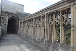 More images |
| Little Cloister House | Gloucester Cathedral, Gloucester | House | 13th century | 23 January 1952 | SO8311118865 51°52′05″N 2°14′48″W / 51.868102°N 2.246692°W / 51.868102; -2.246692 (Little Cloister House) | 1271579 |  More images |
| Llanthony Priory, Remains of Outer Gatehouse | Gloucester | Augustinian Monastery | 1494–1500 | 23 January 1952 | SO8229718025 51°51′38″N 2°15′30″W / 51.860525°N 2.258471°W / 51.860525; -2.258471 (Llanthony Priory, Remains of Outer Gatehouse) | 1271694 | 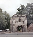 More images |
| Llanthony Priory, Remains of Precinct Wall North of Inner Gatehouse | Gloucester | Precinct Wall | 15th century | 23 January 1952 | SO8234718066 51°51′39″N 2°15′28″W / 51.860895°N 2.257747°W / 51.860895; -2.257747 (Llanthony Priory, Remains of Precinct Wall North of Inner Gatehouse) | 1271695 |  More images |
| Llanthony Priory, Remains of Precinct Wall South of Outer Gatehouse | Gloucester | Precinct Wall | Early 16th century | 23 January 1952 | SO8228117997 51°51′37″N 2°15′31″W / 51.860272°N 2.258702°W / 51.860272; -2.258702 (Llanthony Priory, Remains of Precinct Wall South of Outer Gatehouse) | 1271696 |  |
| Llanthony Priory, Remains of Range on South Side of Inner Court | Gloucester | Augustinian Monastery | Early 16th century | 23 January 1952 | SO8236317952 51°51′36″N 2°15′27″W / 51.85987°N 2.257509°W / 51.85987; -2.257509 (Llanthony Priory, Remains of Range on South Side of Inner Court) | 1271697 | 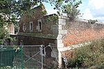 More images |
| Llanthony Priory, Remains of Tythe Barn on North Side of Inner Court | Gloucester | Augustinian Monastery | 15th century | 23 January 1952 | SO8242718046 51°51′39″N 2°15′24″W / 51.860718°N 2.256584°W / 51.860718; -2.256584 (Llanthony Priory, Remains of Tythe Barn on North Side of Inner Court) | 1271698 |  |
| New Inn | 16–20, Northgate, Gloucester | Inn | Mid 15th century | 23 January 1952 | SO8321218587 51°51′56″N 2°14′43″W / 51.865606°N 2.245212°W / 51.865606; -2.245212 (New Inn) | 1245714 |  More images |
| North Precinct Wall | Gloucester | Abbey wall | 12th century | 23 January 1952 | SO8311218929 51°52′07″N 2°14′48″W / 51.868678°N 2.246681°W / 51.868678; -2.246681 (North Precinct Wall) | 1271580 |  |
| Old Judges House | Gloucester | Jettied House | Late 15th century | 23 January 1952 | SO8311218632 51°51′58″N 2°14′48″W / 51.866008°N 2.246666°W / 51.866008; -2.246666 (Old Judges House) | 1245450 |  More images |
| Our Lady's Well (within Field approx. 350m West of St Swithun's Road) | Hempsted, Gloucester | Holy Well | 18th century or 19th century | 10 January 1955 | SO8144717323 51°51′15″N 2°16′15″W / 51.854185°N 2.270776°W / 51.854185; -2.270776 (Our Lady's Well (within Field approx. 350m West of St Swithun's Road)) | 1271744 |  More images |
| Passage from Cathedral Cloisters to Former Monastic Infirmary | Gloucester | Cathedral | 13th century | 23 January 1952 | SO8312618846 51°52′05″N 2°14′47″W / 51.867932°N 2.246474°W / 51.867932; -2.246474 (Passage from Cathedral Cloisters to Former Monastic Infirmary) | 1271582 | 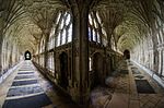 More images |
| Remains of Monastic Infirmary | Gloucester | Abbey | Early 13th century | 23 January 1952 | SO8314718865 51°52′05″N 2°14′46″W / 51.868103°N 2.246169°W / 51.868103; -2.246169 (Remains of Monastic Infirmary) | 1271583 |  More images |
| Remains of Reservoir, North West Corner of Cathedral Cloister Garth | Gloucester | Reservoir | Early 13th century | 23 January 1952 | SO8309118835 51°52′04″N 2°14′49″W / 51.867832°N 2.246981°W / 51.867832; -2.246981 (Remains of Reservoir, North West Corner of Cathedral Cloister Garth) | 1245955 |  |
| St Marys Gate adjoining No 14 College Green | Gloucester | Gate | Late 12th century | 23 January 1952 | SO8300818865 51°52′05″N 2°14′53″W / 51.868099°N 2.248188°W / 51.868099; -2.248188 (St Marys Gate adjoining No 14 College Green) | 1245897 | 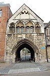 More images |
| St Michaels Gate | Gloucester | Gate | 14th century | 23 January 1952 | SO8309318698 51°52′00″N 2°14′49″W / 51.8666°N 2.246946°W / 51.8666; -2.246946 (St Michaels Gate) | 1245905 |  More images |
| St Oswalds Priory | Gloucester | Church | c900 | 23 January 1952 | SO8304019007 51°52′10″N 2°14′52″W / 51.869377°N 2.247731°W / 51.869377; -2.247731 (St Oswalds Priory) | 1245658 |  More images |
| The Fleece Hotel | Gloucester | Inn | 15th century | 23 January 1952 | SO8309518588 51°51′56″N 2°14′49″W / 51.865611°N 2.246911°W / 51.865611; -2.246911 (The Fleece Hotel) | 1245447 |  More images |
| 9 and 9A, Southgate Street (Costa Coffee) | Gloucester | House | 1665 | 23 January 1952 | SO8314818515 51°51′54″N 2°14′46″W / 51.864957°N 2.246138°W / 51.864957; -2.246138 (9 and 9A, Southgate Street (Costa Coffee)) | 1271748 |  More images |
Notes
- ^ The date given is the date used by Historic England as significant for the initial building or that of an important part in the structure's description.
- ^ Sometimes known as OSGB36, the grid reference is based on the British national grid reference system used by the Ordnance Survey.
- ^ The "List Entry Number" is a unique number assigned to each listed building and scheduled monument by Historic England.
References
English Heritage Images of England
External links
- v
- t
- e
- Bedfordshire
- Berkshire
- Bristol
- Buckinghamshire
- Cambridgeshire
- Cheshire
- Cornwall
- Cumbria
- Derbyshire
- Devon
- Dorset
- Durham
- East Sussex
- East Riding of Yorkshire
- Essex
- Gloucestershire
- Greater London
- Greater Manchester
- Hampshire
- Herefordshire
- Hertfordshire
- Isle of Wight
- Kent
- Lancashire
- Leicestershire
- Lincolnshire
- Merseyside
- Norfolk
- North Yorkshire
- Northamptonshire
- Northumberland
- Nottinghamshire
- Oxfordshire
- Rutland
- Shropshire
- Somerset
- South Yorkshire
- Staffordshire
- Suffolk
- Surrey
- Tyne and Wear
- Warwickshire
- West Midlands
- West Sussex
- West Yorkshire
- Wiltshire
- Worcestershire
- Babergh
- Bath and North East Somerset
- Bradford
- Brighton and Hove
- Broadland
- Cheltenham
- Cheshire East
- Cheshire West and Chester
- Cotswold
- Craven
- Dartford
- Dover
- Forest Heath
- Forest of Dean
- Ipswich
- Maidstone
- Mendip
- Mid Suffolk
- North Somerset
- Sedgemoor
- South Gloucestershire
- South Somerset
- St Edmundsbury
- Stroud
- Suffolk Coastal
- Taunton Deane
- Tewkesbury
- Waveney
- West Somerset
- Churches
- War memorials
- 20th century


