Grade I listed buildings in Broadland
Map all coordinates using OpenStreetMap
Download coordinates as:
- KML
- GPX (all coordinates)
- GPX (primary coordinates)
- GPX (secondary coordinates)
There are over 9,000 Grade I listed buildings in England. This page is a list of these buildings in the district of Broadland in Norfolk.
List of buildings
| Name | Location | Type | Completed [note 1] | Date designated | Grid ref.[note 2] Geo-coordinates | Entry number [note 3] | Image |
|---|---|---|---|---|---|---|---|
| Church of St Edmund | Acle | Parish church | 13th century | 25 September 1962 | TG4011810292 52°38′14″N 1°32′50″E / 52.637203°N 1.547342°E / 52.637203; 1.547342 (Church of St Edmund) | 1372674 | 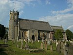 More images |
| Parish Church of Saint Michael including churchyard boundary wall | Aylsham | Parish church | 14th century | 10 May 1961 | TG1926227008 52°47′46″N 1°15′03″E / 52.796053°N 1.250813°E / 52.796053; 1.250813 (Parish Church of Saint Michael including churchyard boundary wall) | 1051583 |  More images |
| The Old Hall | Aylsham | Hall house | 1686 | 19 January 1952 | TG1884527424 52°48′00″N 1°14′42″E / 52.799956°N 1.244917°E / 52.799956; 1.244917 (The Old Hall) | 1050830 |  More images |
| Church of All Saints, Beighton | Beighton | Parish church | 14th century | 25 September 1962 | TG3866508298 52°37′12″N 1°31′28″E / 52.619952°N 1.524473°E / 52.619952; 1.524473 (Church of All Saints, Beighton) | 1051445 |  More images |
| Church of St Mary, Moulton | Moulton St Mary, Beighton | Church (redundant) | 12th century | 25 September 1962 | TG4023906670 52°36′17″N 1°32′47″E / 52.604651°N 1.546496°E / 52.604651; 1.546496 (Church of St Mary, Moulton) | 1051486 |  More images |
| Church of St Peter | Belaugh | Parish church | 12th century | 10 May 1961 | TG2890518413 52°42′54″N 1°23′15″E / 52.714922°N 1.387583°E / 52.714922; 1.387583 (Church of St Peter) | 1050879 |  More images |
| Blickling Hall | Blickling | Country house | c.1619–27 | 19 January 1952 | TG1789428689 52°48′42″N 1°13′54″E / 52.811694°N 1.231677°E / 52.811694; 1.231677 (Blickling Hall) | 1051428 |  More images |
| Service range to south-east of Blickling Hall | Blickling | Stable | c.1620 | 28 March 1988 | TG1789428626 52°48′40″N 1°13′54″E / 52.811128°N 1.231635°E / 52.811128; 1.231635 (Service range to south-east of Blickling Hall) | 1051429 |  More images |
| Service range to south-west of Blickling Hall | Blickling | Office | 1624 | 28 March 1988 | TG1784128643 52°48′41″N 1°13′51″E / 52.811302°N 1.230861°E / 52.811302; 1.230861 (Service range to south-west of Blickling Hall) | 1372691 | 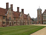 More images |
| Church of St Andrew and St Peter | Blofield | Church | 14th century and later | 25 September 1962 | TG3353709196 52°37′49″N 1°26′58″E / 52.630238°N 1.4495°E / 52.630238; 1.4495 (Church of St Andrew and St Peter) | 1304595 |  More images |
| Church of St Michael | Braydeston, Brundall | Parish church | 13th century and later | 25 September 1962 | TG3373408682 52°37′32″N 1°27′07″E / 52.625541°N 1.452042°E / 52.625541; 1.452042 (Church of St Michael) | 1152849 |  More images |
| Church of St Mary the Virgin | Burgh, Burgh and Tuttington | Parish church | c.1200 | 10 May 1961 | TG2177525052 52°46′39″N 1°17′12″E / 52.777472°N 1.286697°E / 52.777472; 1.286697 (Church of St Mary the Virgin) | 1050928 |  More images |
| The Parish Church of St Agnes | Cawston | Parish church | 14th century | 10 May 1961 | TG1340423844 52°46′12″N 1°09′43″E / 52.77°N 1.162008°E / 52.77; 1.162008 (The Parish Church of St Agnes) | 1263465 | 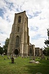 More images |
| Parish Church of St John the Baptist | Coltishall | Parish church | 15th century | 10 May 1961 | TG2715419758 52°43′40″N 1°21′45″E / 52.72773°N 1.362637°E / 52.72773; 1.362637 (Parish Church of St John the Baptist) | 1177913 |  More images |
| Parish Church of St Peter | Crostwick | Parish church | 15th century | 10 May 1961 | TG2578615873 52°41′36″N 1°20′23″E / 52.693437°N 1.339749°E / 52.693437; 1.339749 (Parish Church of St Peter) | 1372937 |  More images |
| Church of Holy Innocents | Foulsham | Church | 13th century | 10 May 1961 | TG0328225064 52°47′05″N 1°00′47″E / 52.784854°N 1.012951°E / 52.784854; 1.012951 (Church of Holy Innocents) | 1050984 |  More images |
| Church of St Andrew | Wickhampton, Freethorpe | Parish church | 13th century and later | 25 September 1962 | TG4272905467 52°35′34″N 1°34′56″E / 52.592752°N 1.58231°E / 52.592752; 1.58231 (Church of St Andrew) | 1304784 | 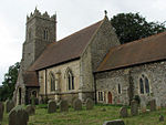 More images |
| Church of St Mary | Great Witchingham | Church | 14th century | 10 May 1961 | TG1035020047 52°44′14″N 1°06′52″E / 52.737114°N 1.114376°E / 52.737114; 1.114376 (Church of St Mary) | 1076900 |  More images |
| Church of St Peter | Guestwick | Parish church | c.1100 | 10 May 1961 | TG0612227048 52°48′06″N 1°03′22″E / 52.801587°N 1.056248°E / 52.801587; 1.056248 (Church of St Peter) | 1050963 |  More images |
| Church of St Peter and St Paul | Halvergate | Parish church | Tower c.1450 | 25 September 1962 | TG4175406691 52°36′15″N 1°34′08″E / 52.604169°N 1.568838°E / 52.604169; 1.568838 (Church of St Peter and St Paul) | 1152737 |  More images |
| Former tower finial, 22 cm south-west of south-west nave buttress of Church of St Peter and St Paul | Halvergate | Sculpture | Late 17th century | 26 February 1987 | TG4174406684 52°36′15″N 1°34′07″E / 52.60411°N 1.568686°E / 52.60411; 1.568686 (Former tower finial, 22 cm south-west of south-west nave buttress of Church of St Peter and St Paul) | 1051463 |  |
| Church of All Saints | Hemblington | Parish church | 12th century | 25 September 1962 | TG3530211514 52°39′01″N 1°28′38″E / 52.650276°N 1.47718°E / 52.650276; 1.47718 (Church of All Saints) | 1051490 | 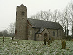 More images |
| Parish Church of St Mary the Virgin and St Botolph | Hevingham | Parish church | 14th century | 10 May 1961 | TG2013122319 52°45′13″N 1°15′38″E / 52.753616°N 1.260531°E / 52.753616; 1.260531 (Parish Church of St Mary the Virgin and St Botolph) | 1250099 | 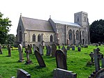 More images |
| Church of St Peter and St Paul | Heydon | Parish church | 14th century | 10 May 1961 | TG1140027405 52°48′10″N 1°08′05″E / 52.802751°N 1.134649°E / 52.802751; 1.134649 (Church of St Peter and St Paul) | 1305337 |  More images |
| Heydon Hall | Heydon | Country house | 1581–84 | 19 January 1952 | TG1165027695 52°48′19″N 1°08′19″E / 52.805256°N 1.138539°E / 52.805256; 1.138539 (Heydon Hall) | 1372695 |  More images |
| Church of the Blessed Virgin and St Andrew | Horsham St Faith and Newton St Faith | Parish church | c.1200 | 10 May 1961 | TG2160215089 52°41′17″N 1°16′39″E / 52.688127°N 1.277418°E / 52.688127; 1.277418 (Church of the Blessed Virgin and St Andrew) | 1372959 | 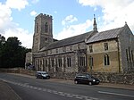 More images |
| The Priory | Horsham St Faith and Newton St Faith | Farmhouse | 12th-century origin | 19 January 1952 | TG2159715176 52°41′20″N 1°16′39″E / 52.68891°N 1.277402°E / 52.68891; 1.277402 (The Priory) | 1152454 |  More images |
| Church of St Andrew | North Burlingham, Lingwood and Burlingham | Parish church | 14th century | 25 September 1962 | TG3653810110 52°38′14″N 1°29′40″E / 52.637141°N 1.49441°E / 52.637141; 1.49441 (Church of St Andrew) | 1051522 |  More images |
| Church of St Edmund | South Burlingham, Lingwood and Burlingham | Parish church | 12th century | 25 September 1962 | TG3722808247 52°37′12″N 1°30′12″E / 52.620124°N 1.50325°E / 52.620124; 1.50325 (Church of St Edmund) | 1152884 |  More images |
| Church of St Peter | Lingwood, Lingwood and Burlingham | Parish church | Mainly 14th century | 25 September 1962 | TG3607209038 52°37′40″N 1°29′12″E / 52.627725°N 1.486771°E / 52.627725; 1.486771 (Church of St Peter) | 1051521 |  More images |
| Church of All Saints | Marsham | Parish church | 13th century | 10 May 1961 | TG1966623706 52°45′59″N 1°15′16″E / 52.766253°N 1.254582°E / 52.766253; 1.254582 (Church of All Saints) | 1250332 |  More images |
| Church of All Saints | Rackheath | Church | Early 14th century | 10 May 1961 | TG2702214960 52°41′05″N 1°21′27″E / 52.684727°N 1.357376°E / 52.684727; 1.357376 (Church of All Saints) | 1050859 |  More images |
| Church of St John the Baptist | Reedham | Parish church | 14th century | 25 September 1962 | TG4278102496 52°33′58″N 1°34′51″E / 52.566073°N 1.580901°E / 52.566073; 1.580901 (Church of St John the Baptist) | 1152823 |  More images |
| Church of the Nativity of St Mary with brick retaining wall to the north | Reepham | Parish church | 13th century | 10 May 1961 | TG1013822856 52°45′45″N 1°06′47″E / 52.762411°N 1.113039°E / 52.762411; 1.113039 (Church of the Nativity of St Mary with brick retaining wall to the north) | 1076872 |  More images |
| Church of St Peter | Ringland | Parish church | 13th century | 10 May 1961 | TG1338014068 52°40′56″N 1°09′19″E / 52.682261°N 1.155307°E / 52.682261; 1.155307 (Church of St Peter) | 1171129 |  More images |
| Church of All Saints | Salhouse | Parish church | 14th century | 10 May 1961 | TG3034014976 52°41′00″N 1°24′23″E / 52.683471°N 1.406383°E / 52.683471; 1.406383 (Church of All Saints) | 1295085 |  More images |
| Church of Saints Peter and Paul | Salle | Church | First half of 15th century | 10 May 1961 | TG1103624888 52°46′49″N 1°07′39″E / 52.780301°N 1.127635°E / 52.780301; 1.127635 (Church of Saints Peter and Paul) | 1306145 | 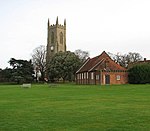 More images |
| Church of St Mary | South Walsham | Parish church | 14th century | 25 September 1962 | TG3653413253 52°39′55″N 1°29′48″E / 52.665345°N 1.496603°E / 52.665345; 1.496603 (Church of St Mary) | 1372682 |  More images |
| Church of St Peter | Spixworth | Parish church | 14th century | 10 May 1961 | TG2406815770 52°41′36″N 1°18′51″E / 52.693225°N 1.314302°E / 52.693225; 1.314302 (Church of St Peter) | 1152695 |  More images |
| Parish Church of St Mary and St Margaret | Sprowston | Parish church | 14th century | 10 May 1961 | TG2495012528 52°39′50″N 1°19′30″E / 52.663765°N 1.325118°E / 52.663765; 1.325118 (Parish Church of St Mary and St Margaret) | 1372986 |  More images |
| Church of St Margaret | Stratton Strawless | Parish church | 15th century | 10 May 1961 | TG2215820767 52°44′20″N 1°17′22″E / 52.738859°N 1.289464°E / 52.738859; 1.289464 (Church of St Margaret) | 1372972 |  More images |
| Church of St Nicholas | Buckenham, Strumpshaw | Church | 13th century and later | 25 September 1962 | TG3557005875 52°35′58″N 1°28′38″E / 52.59956°N 1.477117°E / 52.59956; 1.477117 (Church of St Nicholas) | 1304389 |  More images |
| Church of St Peter | Strumpshaw | Parish church | 14th century | 25 September 1962 | TG3491607722 52°36′59″N 1°28′08″E / 52.616417°N 1.468789°E / 52.616417; 1.468789 (Church of St Peter) | 1051500 |  More images |
| Church of St Margaret | Swannington | Parish church | 13th century | 10 May 1961 | TG1341419281 52°43′45″N 1°09′33″E / 52.729039°N 1.15919°E / 52.729039; 1.15919 (Church of St Margaret) | 1050924 |  More images |
| Parish Church of St Edmund | Taverham | Parish church | 14th century and later | 10 May 1961 | TG1608413816 52°40′44″N 1°11′42″E / 52.678929°N 1.195078°E / 52.678929; 1.195078 (Parish Church of St Edmund) | 1372667 |  More images |
| Church of St Margaret | Upton, Upton with Fishley | Parish church | 14th century | 25 September 1962 | TG3931012168 52°39′16″N 1°32′12″E / 52.654393°N 1.536785°E / 52.654393; 1.536785 (Church of St Margaret) | 1372730 |  More images |
| Church of All Saints including boundary wall to churchyard | Weston Longville | Parish church | 13th century | 10 May 1961 | TG1134415866 52°41′57″N 1°07′35″E / 52.699198°N 1.126389°E / 52.699198; 1.126389 (Church of All Saints including boundary wall to churchyard) | 1372689 |  More images |
| Church of St Andrew | Wood Dalling | Parish church | 13th century | 10 May 1961 | TG0897426977 52°47′59″N 1°05′54″E / 52.799854°N 1.098444°E / 52.799854; 1.098444 (Church of St Andrew) | 1172116 |  More images |
| Church of St Helen | Ranworth, Woodbastwick | Parish church | 15th century | 25 September 1962 | TG3560414770 52°40′46″N 1°29′02″E / 52.679362°N 1.483961°E / 52.679362; 1.483961 (Church of St Helen) | 1154645 |  More images |
| Church of St Mary | Wroxham | Parish church | 12th century | 10 May 1961 | TG2965617540 52°42′24″N 1°23′53″E / 52.70677°N 1.398071°E / 52.70677; 1.398071 (Church of St Mary) | 1050868 |  More images |
See also
Notes
- ^ The date given is the date used by Historic England as significant for the initial building or that of an important part in the structure's description.
- ^ Sometimes known as OSGB36, the grid reference is based on the British national grid reference system used by the Ordnance Survey.
- ^ The "List Entry Number" is a unique number assigned to each listed building and scheduled monument by Historic England.
External links
- v
- t
- e
- Bedfordshire
- Berkshire
- Bristol
- Buckinghamshire
- Cambridgeshire
- Cheshire
- Cornwall
- Cumbria
- Derbyshire
- Devon
- Dorset
- Durham
- East Sussex
- East Riding of Yorkshire
- Essex
- Gloucestershire
- Greater London
- Greater Manchester
- Hampshire
- Herefordshire
- Hertfordshire
- Isle of Wight
- Kent
- Lancashire
- Leicestershire
- Lincolnshire
- Merseyside
- Norfolk
- North Yorkshire
- Northamptonshire
- Northumberland
- Nottinghamshire
- Oxfordshire
- Rutland
- Shropshire
- Somerset
- South Yorkshire
- Staffordshire
- Suffolk
- Surrey
- Tyne and Wear
- Warwickshire
- West Midlands
- West Sussex
- West Yorkshire
- Wiltshire
- Worcestershire
- Babergh
- Bath and North East Somerset
- Bradford
- Brighton and Hove
- Broadland
- Cheltenham
- Cheshire East
- Cheshire West and Chester
- Cotswold
- Craven
- Dartford
- Dover
- Forest Heath
- Forest of Dean
- Ipswich
- Maidstone
- Mendip
- Mid Suffolk
- North Somerset
- Sedgemoor
- South Gloucestershire
- South Somerset
- St Edmundsbury
- Stroud
- Suffolk Coastal
- Taunton Deane
- Tewkesbury
- Waveney
- West Somerset
- Churches
- War memorials
- 20th century


