National Register of Historic Places listings in Madison County, Iowa

This is a list of the National Register of Historic Places listings in Madison County, Iowa.
This is intended to be a complete list of the properties and districts on the National Register of Historic Places in Madison County, Iowa, United States. Latitude and longitude coordinates are provided for many National Register properties and districts; these locations may be seen together in a map.[1]
There are 53 properties listed on the National Register in the county and at least one former listing.
This National Park Service list is complete through NPS recent listings posted July 12, 2024.[2]
Map all coordinates using OpenStreetMap
Download coordinates as:
- KML
- GPX (all coordinates)
- GPX (primary coordinates)
- GPX (secondary coordinates)
| [3] | Name on the Register[4] | Image | Date listed[5] | Location | City or town | Description |
|---|---|---|---|---|---|---|
| 1 | James Allen Stone Barn | Upload image | September 29, 1987 (#87001658) | 2½ miles southeast of Earlham 41°26′56″N 94°06′20″W / 41.448889°N 94.105556°W / 41.448889; -94.105556 (James Allen Stone Barn) | Earlham | |
| 2 | George and Susan Guiberson Armstrong House | Upload image | September 29, 1987 (#87001668) | 2½ miles north of Winterset on G4R 41°23′18″N 93°58′26″W / 41.388333°N 93.973889°W / 41.388333; -93.973889 (George and Susan Guiberson Armstrong House) | Winterset | |
| 3 | C.D. and Eliza Heath Bevington Privy |  | September 29, 1987 (#87001669) | 805 S. 2nd Ave. 41°19′40″N 94°00′53″W / 41.327778°N 94.014722°W / 41.327778; -94.014722 (C.D. and Eliza Heath Bevington Privy) | Winterset | |
| 4 | C.D. Bevington House and Stone Barn | 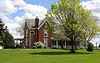 | December 12, 1976 (#76000785) | 805 S. 2nd Ave. 41°19′40″N 94°00′54″W / 41.327778°N 94.015°W / 41.327778; -94.015 (C.D. Bevington House and Stone Barn) | Winterset | |
| 5 | Bricker-Price Block | Upload image | January 17, 2017 (#100000487) | 105-115 S. Chestnut Ave. 41°29′29″N 94°07′23″W / 41.491423°N 94.122971°W / 41.491423; -94.122971 (Bricker-Price Block) | Earlham | |
| 6 | Seymour Church House | Upload image | September 29, 1987 (#87001683) | U.S. Route 169 41°24′08″N 94°02′25″W / 41.402222°N 94.040278°W / 41.402222; -94.040278 (Seymour Church House) | Winterset | |
| 7 | W.J. and Nettie J. Cornell House |  | January 11, 1991 (#90002132) | 602 W. Court Ave. 41°20′03″N 94°01′15″W / 41.334167°N 94.020833°W / 41.334167; -94.020833 (W.J. and Nettie J. Cornell House) | Winterset | |
| 8 | J.D. Craven Women's Relief Corps Hall | Upload image | January 19, 1984 (#84001274) | South St. 41°12′50″N 94°11′07″W / 41.213889°N 94.185139°W / 41.213889; -94.185139 (J.D. Craven Women's Relief Corps Hall) | Macksburg | |
| 9 | Cunningham Bridge | Upload image | May 15, 1998 (#98000509) | Upland Trail over the North River 41°24′06″N 93°51′40″W / 41.401667°N 93.861111°W / 41.401667; -93.861111 (Cunningham Bridge) | Bevington | |
| 10 | Cutler-Donahoe Covered Bridge |  | October 8, 1976 (#76000787) | Winterset City Park 41°19′52″N 94°00′31″W / 41.331111°N 94.008611°W / 41.331111; -94.008611 (Cutler-Donahoe Covered Bridge) | Winterset | |
| 11 | John and Amanda Bigler Drake House | Upload image | September 29, 1987 (#87001670) | 11 miles west of Winterset on Iowa Highway 92 41°18′57″N 94°13′22″W / 41.315833°N 94.222778°W / 41.315833; -94.222778 (John and Amanda Bigler Drake House) | Winterset | |
| 12 | Duff Barn | Upload image | March 18, 1993 (#87001672) | 1½ miles north of Winterset on U.S. Route 169 41°22′03″N 94°00′53″W / 41.3675°N 94.014722°W / 41.3675; -94.014722 (Duff Barn) | Winterset | |
| 13 | John M. Duncan House | Upload image | September 29, 1987 (#87001673) | ½ mile south of Winterset on County Road P69 41°19′12″N 94°01′00″W / 41.32°N 94.016667°W / 41.32; -94.016667 (John M. Duncan House) | Winterset | |
| 14 | Earlham Public School |  | June 2, 1982 (#82002631) | 809 Main St. 41°29′31″N 94°07′16″W / 41.491944°N 94.121111°W / 41.491944; -94.121111 (Earlham Public School) | Earlham | |
| 15 | John and Elizabeth McMurn Early House | Upload image | March 18, 1993 (#87001653) | 1 mile south of County Road G31 between County Roads P53 and P57 41°23′21″N 94°09′27″W / 41.389167°N 94.1575°W / 41.389167; -94.1575 (John and Elizabeth McMurn Early House) | Earlham | |
| 16 | Henry and Elizabeth Adkinson Evans House | Upload image | September 29, 1987 (#87001674) | ½ mile east of U.S. Route 169 on County Road G50 41°18′42″N 93°59′33″W / 41.311667°N 93.9925°W / 41.311667; -93.9925 (Henry and Elizabeth Adkinson Evans House) | Winterset | |
| 17 | W.T. Ford House | Upload image | September 29, 1987 (#87001654) | 2½ miles south of Earlham on County Road P57 41°27′13″N 94°08′06″W / 41.453611°N 94.135°W / 41.453611; -94.135 (W.T. Ford House) | Earlham | |
| 18 | Guiberson House |  | July 10, 1979 (#79003697) | 302 S. 4th Ave. 41°19′56″N 94°01′06″W / 41.332361°N 94.018333°W / 41.332361; -94.018333 (Guiberson House) | Winterset | |
| 19 | Daniel and Nancy Swaford Henderson House | Upload image | September 29, 1987 (#87001655) | 8 miles south of Earlham on County Road P57 41°22′37″N 94°07′55″W / 41.376944°N 94.131944°W / 41.376944; -94.131944 (Daniel and Nancy Swaford Henderson House) | Earlham | |
| 20 | Hogback Covered Bridge |  | August 28, 1976 (#76000788) | 4 miles north of Winterset 41°23′09″N 94°03′00″W / 41.385833°N 94.05°W / 41.385833; -94.05 (Hogback Covered Bridge) | Winterset | |
| 21 | Holliwell Covered Bridge |  | August 28, 1976 (#76000789) | 4 miles southeast of Winterset 41°19′21″N 93°57′33″W / 41.3225°N 93.959167°W / 41.3225; -93.959167 (Holliwell Covered Bridge) | Winterset | |
| 22 | John S. and Elizabeth Beem Holmes Barn | Upload image | September 29, 1987 (#87001665) | County Road G50 41°17′00″N 93°57′14″W / 41.283333°N 93.953889°W / 41.283333; -93.953889 (John S. and Elizabeth Beem Holmes Barn) | St. Charles | |
| 23 | Emily Hornback House |  | September 29, 1987 (#87001687) | 605 N. 1st St. 41°20′22″N 94°00′46″W / 41.339444°N 94.012778°W / 41.339444; -94.012778 (Emily Hornback House) | Winterset | |
| 24 | Imes Covered Bridge |  | February 9, 1979 (#76000784) | Iowa Highway 251 41°17′21″N 93°48′03″W / 41.289167°N 93.800833°W / 41.289167; -93.800833 (Imes Covered Bridge) | St. Charles | |
| 25 | Miles and Elizabeth Smith Kellogg House | Upload image | June 19, 2017 (#87002140) | Off County Road G50 41°19′04″N 93°59′00″W / 41.317812°N 93.983416°W / 41.317812; -93.983416 (Miles and Elizabeth Smith Kellogg House) | Winterset vicinity | |
| 26 | Judge W.H. and Emma Lewis Historic District | Upload image | August 27, 2020 (#100005493) | 1145 Summit St. West 41°15′04″N 94°01′42″W / 41.251111°N 94.028212°W / 41.251111; -94.028212 (Judge W.H. and Emma Lewis Historic District) | Winterset | |
| 27 | John Andrew and Sara Macumber Ice House | Upload image | March 18, 1993 (#87001675) | On County Road G53 1½ miles east of its junction with County Road P69 41°15′04″N 94°03′56″W / 41.251111°N 94.065556°W / 41.251111; -94.065556 (John Andrew and Sara Macumber Ice House) | Winterset | |
| 28 | Madison County Courthouse |  | August 13, 1976 (#76000790) | City Sq. 41°20′06″N 94°00′50″W / 41.335°N 94.013889°W / 41.335; -94.013889 (Madison County Courthouse) | Winterset | |
| 29 | McDonald House | Upload image | March 18, 1993 (#87001676) | 3½ miles west of Winterset off Iowa Highway 92 41°21′32″N 94°05′31″W / 41.358889°N 94.091944°W / 41.358889; -94.091944 (McDonald House) | Winterset | |
| 30 | Peter and Isabelle McCulloch McQuie Milkhouse | Upload image | September 29, 1987 (#87001656) | Southwest of Earlham 41°25′51″N 94°09′34″W / 41.430833°N 94.159444°W / 41.430833; -94.159444 (Peter and Isabelle McCulloch McQuie Milkhouse) | Earlham | |
| 31 | Miller Bridge | Upload image | May 15, 1998 (#98000508) | McBride Trail over an unnamed stream 41°24′45″N 93°56′34″W / 41.4125°N 93.942778°W / 41.4125; -93.942778 (Miller Bridge) | Winterset | |
| 32 | Morgan Bridge | Upload image | May 15, 1998 (#98000507) | Maple Lane over a branch of Clanton Creek 41°10′16″N 93°55′55″W / 41.171111°N 93.931944°W / 41.171111; -93.931944 (Morgan Bridge) | Old Peru | |
| 33 | William Anzi Nichols House | Upload image | September 29, 1987 (#87001677) | 1 mile east of Winterset on Iowa Highway 92 41°20′42″N 93°59′57″W / 41.345°N 93.999167°W / 41.345; -93.999167 (William Anzi Nichols House) | Winterset | |
| 34 | North River Stone Schoolhouse |  | April 11, 1977 (#77000537) | North of Winterset off U.S. Route 169 41°24′10″N 94°02′32″W / 41.402778°N 94.042222°W / 41.402778; -94.042222 (North River Stone Schoolhouse) | Winterset | |
| 35 | William Ogburn House | Upload image | September 29, 1987 (#87001660) | 1½ miles north of East Peru 41°15′03″N 93°55′19″W / 41.250833°N 93.921944°W / 41.250833; -93.921944 (William Ogburn House) | East Peru | |
| 36 | Hogan and Martha A. Runkle Queen House | Upload image | September 29, 1987 (#87001667) | 5 miles west of St. Charles on County Road G50 41°18′05″N 93°53′51″W / 41.301389°N 93.8975°W / 41.301389; -93.8975 (Hogan and Martha A. Runkle Queen House) | St. Charles | |
| 37 | Roseman Covered Bridge |  | September 1, 1976 (#76000792) | West of Winterset off Iowa Highway 92 41°17′31″N 94°09′05″W / 41.291944°N 94.151389°W / 41.291944; -94.151389 (Roseman Covered Bridge) | Winterset | |
| 38 | St. Patrick's Church |  | December 12, 1978 (#78001245) | Northwest of Cumming 41°25′39″N 93°47′34″W / 41.4275°N 93.792778°W / 41.4275; -93.792778 (St. Patrick's Church) | Cumming | |
| 39 | John and Fredericka Meyer Schnellbacher House | Upload image | September 29, 1987 (#87001678) | On County Road G47 1½ miles east of its junction with County Road P53 41°17′26″N 94°08′40″W / 41.290556°N 94.144444°W / 41.290556; -94.144444 (John and Fredericka Meyer Schnellbacher House) | Winterset | |
| 40 | Nicholas Schoenenberger House and Barn | Upload image | July 12, 1984 (#84001275) | Off Iowa Highway 169 41°13′17″N 93°59′58″W / 41.221389°N 93.999444°W / 41.221389; -93.999444 (Nicholas Schoenenberger House and Barn) | Winterset | |
| 41 | William and Mary (Messersmith) Seerley Barn and Milkhouse-Smokehouse |  | August 20, 2009 (#09000621) | 1840 137th Lane 41°26′45″N 94°05′24″W / 41.445833°N 94.09°W / 41.445833; -94.09 (William and Mary (Messersmith) Seerley Barn and Milkhouse-Smokehouse) | Earlham | |
| 42 | William R. and Martha Foster Shriver House |  | March 18, 1993 (#87001689) | 616 E. Court Ave. 41°20′03″N 94°00′25″W / 41.334167°N 94.006944°W / 41.334167; -94.006944 (William R. and Martha Foster Shriver House) | Winterset | |
| 43 | Hiram C. Smith House | Upload image | September 29, 1987 (#87001684) | 6 miles west of Winterset on Iowa Highway 92 41°19′48″N 94°08′34″W / 41.33°N 94.142639°W / 41.33; -94.142639 (Hiram C. Smith House) | Winterset | |
| 44 | Hiram C. Smith Milking Shed | Upload image | September 29, 1987 (#87001686) | 6 miles west of Winterset on Iowa Highway 92 41°19′47″N 94°08′32″W / 41.329722°N 94.142222°W / 41.329722; -94.142222 (Hiram C. Smith Milking Shed) | Winterset | |
| 45 | Sprague, Brown, and Knowlton Store | Upload image | September 29, 1987 (#87001690) | 1st and Court 41°20′03″N 94°00′52″W / 41.334167°N 94.014444°W / 41.334167; -94.014444 (Sprague, Brown, and Knowlton Store) | Winterset | |
| 46 | Miller Richard and Mary Fisher Tidrick House |  | March 18, 1993 (#93000126) | 122 S. 4th Ave. 41°20′01″N 94°01′06″W / 41.333611°N 94.018333°W / 41.333611; -94.018333 (Miller Richard and Mary Fisher Tidrick House) | Winterset | |
| 47 | J.G. and Elizabeth S. Vawter House |  | September 29, 1987 (#87001692) | 223 S. 1st St. 41°19′58″N 94°00′46″W / 41.332778°N 94.012778°W / 41.332778; -94.012778 (J.G. and Elizabeth S. Vawter House) | Winterset | |
| 48 | Henry C. Wallace House |  | January 3, 1985 (#85000005) | 422 W. Jefferson 41°20′07″N 94°01′09″W / 41.335278°N 94.019167°W / 41.335278; -94.019167 (Henry C. Wallace House) | Winterset | |
| 49 | White, Munger and Company Store |  | September 29, 1987 (#87001693) | 102 W. Court 41°20′03″N 94°00′53″W / 41.334167°N 94.014722°W / 41.334167; -94.014722 (White, Munger and Company Store) | Winterset | |
| 50 | Seth and Elizabeth Wilson House | Upload image | September 29, 1987 (#87001659) | 1¾ miles east of County Road P57 on County Road G14 41°28′10″N 94°05′39″W / 41.469444°N 94.094167°W / 41.469444; -94.094167 (Seth and Elizabeth Wilson House) | Earlham | |
| 51 | Winterset City Park Historic District |  | March 10, 2021 (#100006220) | South 9th St. at East South St. 41°19′52″N 94°00′13″W / 41.331209°N 94.003687°W / 41.331209; -94.003687 (Winterset City Park Historic District) | Winterset | |
| 52 | Winterset Courthouse Square Commercial Historic District |  | December 22, 2015 (#15000915) | Roughly bounded by Green & 2nd Sts., 2nd Ave. & alley S. of Court Ave. 41°20′05″N 94°00′51″W / 41.334835°N 94.014156°W / 41.334835; -94.014156 (Winterset Courthouse Square Commercial Historic District) | Winterset | |
| 53 | Winterset High School | Upload image | July 6, 2020 (#100005339) | 110 W. Washington St. 41°19′59″N 94°00′54″W / 41.333074°N 94.015092°W / 41.333074; -94.015092 (Winterset High School) | Winterset |
Former listings
| [3] | Name on the Register | Image | Date listed | Date removed | Location | City or town | Description |
|---|---|---|---|---|---|---|---|
| 1 | Cedar Covered Bridge |  | August 28, 1976 (#76000786) | October 18, 2002 | 1.5 mi. E of Winterset 41°21′57″N 93°59′27″W / 41.365833°N 93.990833°W / 41.365833; -93.990833 (Cedar Covered Bridge) | Winterset vicinity | Destroyed by arsonist on September 3, 2002.[6] Bridge was rebuilt, only to again be destroyed by arsonist in 2017. The bridge has again been rebuilt. |
| 2 | McBride Covered Bridge |  | September 8, 1976 (#76000791) | September 23, 1987 | About 2 mi. NE of Winterset | Winterset vicinity | Destroyed by arson in 1983.[7] |
See also
Wikimedia Commons has media related to National Register of Historic Places in Madison County, Iowa.
- List of National Historic Landmarks in Iowa
- National Register of Historic Places listings in Iowa
- Listings in neighboring counties: Adair, Clarke, Dallas, Union, Warren
References
- ^ The latitude and longitude information provided in this table was derived originally from the National Register Information System, which has been found to be fairly accurate for about 99% of listings. Some locations in this table may have been corrected to current GPS standards.
- ^ National Park Service, United States Department of the Interior, "National Register of Historic Places: Weekly List Actions", retrieved July 12, 2024.
- ^ a b Numbers represent an alphabetical ordering by significant words. Various colorings, defined here, differentiate National Historic Landmarks and historic districts from other NRHP buildings, structures, sites or objects.
- ^ "National Register Information System". National Register of Historic Places. National Park Service. April 24, 2008.
- ^ The eight-digit number below each date is the number assigned to each location in the National Register Information System database, which can be viewed by clicking the number.
- ^ "Bridge blaze is ruled arson". The Des Moines REgister. September 5, 2002. p. A1. Retrieved June 26, 2022 – via Newspapers.com.
- ^ "Man is charged in burning of covered bridge". The Des Moines Register. December 13, 1983. p. M1. Retrieved June 26, 2022 – via Newspapers.com.
- v
- t
- e
- List of U.S. National Historic Landmarks by state:
- Alabama
- Alaska
- Arizona
- Arkansas
- California
- Colorado
- Connecticut
- Delaware
- Florida
- Georgia
- Hawaii
- Idaho
- Illinois
- Indiana
- Iowa
- Kansas
- Kentucky
- Louisiana
- Maine
- Maryland
- Massachusetts
- Michigan
- Minnesota
- Mississippi
- Missouri
- Montana
- Nebraska
- Nevada
- New Hampshire
- New Jersey
- New Mexico
- New York
- North Carolina
- North Dakota
- Ohio
- Oklahoma
- Oregon
- Pennsylvania
- Rhode Island
- South Carolina
- South Dakota
- Tennessee
- Texas
- Utah
- Vermont
- Virginia
- Washington
- West Virginia
- Wisconsin
- Wyoming
 National Register of Historic Places portal
 Category


