National Register of Historic Places listings in Iowa County, Iowa

This is a list of the National Register of Historic Places listings in Iowa County, Iowa.
This is intended to be a complete list of the properties and districts on the National Register of Historic Places in Iowa County, Iowa, United States. Latitude and longitude coordinates are provided for many National Register properties and districts; these locations may be seen together in a map.[1]
There are 11 properties and districts listed on the National Register in the county, including 1 National Historic Landmark.
This National Park Service list is complete through NPS recent listings posted July 12, 2024.[2]
Map all coordinates using OpenStreetMap
Download coordinates as:
- KML
- GPX (all coordinates)
- GPX (primary coordinates)
- GPX (secondary coordinates)
Current listings
| [3] | Name on the Register[4] | Image | Date listed[5] | Location | City or town | Description |
|---|---|---|---|---|---|---|
| 1 | Amana Villages |  | October 15, 1966 (#66000336) | Northeastern Iowa County 41°47′59″N 91°55′15″W / 41.799722°N 91.920833°W / 41.799722; -91.920833 (Amana Villages) | Middle Amana | |
| 2 | E.J. Baird House | Upload image | February 25, 1982 (#82002622) | Jackson and Fremont Sts. 41°34′21″N 92°09′31″W / 41.5725°N 92.158611°W / 41.5725; -92.158611 (E.J. Baird House) | Millersburg | |
| 3 | David and M. Maria Hughes House |  | June 28, 1996 (#96000697) | 101 W. Penn St. 41°39′34″N 92°00′27″W / 41.659444°N 92.0075°W / 41.659444; -92.0075 (David and M. Maria Hughes House) | Williamsburg | |
| 4 | Indian Fish Weir | Upload image | July 21, 1988 (#88001122) | Address Restricted | Middle Amana | The Amana Indian fish weir is believed to have been covered over by river silt, and is no longer visible.[6] |
| 5 | Iowa County Courthouse |  | July 2, 1981 (#81000247) | Court Ave. 41°47′53″N 92°04′14″W / 41.798056°N 92.070556°W / 41.798056; -92.070556 (Iowa County Courthouse) | Marengo | |
| 6 | Ladora Savings Bank |  | August 3, 1990 (#90001196) | 811 Pacific St. 41°45′17″N 92°11′01″W / 41.754722°N 92.183611°W / 41.754722; -92.183611 (Ladora Savings Bank) | Ladora | |
| 7 | Lenox Township Church of the New Jerusalem | 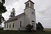 | September 29, 1983 (#83000370) | South of Norway 41°50′50″N 91°55′41″W / 41.847222°N 91.928056°W / 41.847222; -91.928056 (Lenox Township Church of the New Jerusalem) | Lenox Township | |
| 8 | Pilot Grove |  | November 17, 1977 (#77000519) | Southwest of Williamsburg 41°37′49″N 92°05′03″W / 41.630278°N 92.084167°W / 41.630278; -92.084167 (Pilot Grove) | Williamsburg | |
| 9 | Plagmann Round Barn |  | June 30, 1986 (#86001440) | Off Iowa Highway 209 41°43′30″N 92°03′11″W / 41.725°N 92.053056°W / 41.725; -92.053056 (Plagmann Round Barn) | Conroy | |
| 10 | St. Michael's Church, Cemetery, Rectory and Ancient Order of Hibernians Hall |  | January 20, 1983 (#83000371) | East of Parnell on F 52 41°35′24″N 91°54′48″W / 41.59°N 91.913333°W / 41.59; -91.913333 (St. Michael's Church, Cemetery, Rectory and Ancient Order of Hibernians Hall) | Parnell | |
| 11 | Fred G. Turner House |  | June 27, 1985 (#85001381) | Iowa Highway 149 41°33′25″N 92°03′56″W / 41.556944°N 92.065556°W / 41.556944; -92.065556 (Fred G. Turner House) | North English |
See also
Wikimedia Commons has media related to National Register of Historic Places in Iowa County, Iowa.
- List of National Historic Landmarks in Iowa
- National Register of Historic Places listings in Iowa
- Listings in neighboring counties: Benton, Johnson, Keokuk, Linn, Poweshiek, Tama, Washington
References
- ^ The latitude and longitude information provided in this table was derived originally from the National Register Information System, which has been found to be fairly accurate for about 99% of listings. Some locations in this table may have been corrected to current GPS standards.
- ^ National Park Service, United States Department of the Interior, "National Register of Historic Places: Weekly List Actions", retrieved July 12, 2024.
- ^ Numbers represent an alphabetical ordering by significant words. Various colorings, defined here, differentiate National Historic Landmarks and historic districts from other NRHP buildings, structures, sites or objects.
- ^ "National Register Information System". National Register of Historic Places. National Park Service. April 24, 2008.
- ^ The eight-digit number below each date is the number assigned to each location in the National Register Information System database, which can be viewed by clicking the number.
- ^ Whittaker, Willam E. (2013). "The Disappearance of the Amana Indian Fish Weir". Newsletter of the Iowa Archeological Society. 63 (1): 1–5.
- v
- t
- e
- List of U.S. National Historic Landmarks by state:
- Alabama
- Alaska
- Arizona
- Arkansas
- California
- Colorado
- Connecticut
- Delaware
- Florida
- Georgia
- Hawaii
- Idaho
- Illinois
- Indiana
- Iowa
- Kansas
- Kentucky
- Louisiana
- Maine
- Maryland
- Massachusetts
- Michigan
- Minnesota
- Mississippi
- Missouri
- Montana
- Nebraska
- Nevada
- New Hampshire
- New Jersey
- New Mexico
- New York
- North Carolina
- North Dakota
- Ohio
- Oklahoma
- Oregon
- Pennsylvania
- Rhode Island
- South Carolina
- South Dakota
- Tennessee
- Texas
- Utah
- Vermont
- Virginia
- Washington
- West Virginia
- Wisconsin
- Wyoming
 National Register of Historic Places portal
 Category


Municipalities and communities of Iowa County, Iowa, United States | ||
|---|---|---|
County seat: Marengo | ||
| Cities |  | |
| Townships | ||
| CDPs | ||
| Ghost towns | ||
| Footnotes | ‡This populated place also has portions in an adjacent county or counties | |
| ||


