Ubbergen
Village and former municipality in Gelderland, Netherlands

Flag

Coat of arms
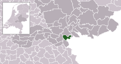
Location in Gelderland
51°50′N 5°55′E / 51.833°N 5.917°E / 51.833; 5.917
(2021)[1]
6574[1]
Ubbergen (Dutch pronunciation: [ʏˈbɛrɣə(n)] ⓘ) is a village and former municipality in the eastern Netherlands, in the province of Gelderland. On 1 January 2015 it merged into the enlarged municipality of Groesbeek, renamed Berg en Dal from 1 January 2016.[3]
Notable people
Notable people who were born in Ubbergen include:
- Don Burgers (1932–2006), politician for the KVP and the CDA
- Amber (1970), Dutch-German singer, songwriter and music producer
- Yelmer Buurman (1987), professional racing driver
Gallery
-
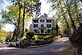 Villa 'De Maartenshof' on the Rijkstraatweg
 -
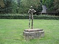 Statue of Nescio (1991) on the Rijksstraatweg
 -
 The school building of Notre Dame des Anges
 -
 'De Refter': monumental building complex
 -
 The 'Bronnenbos': a carr in Ubbergen


References
- ^ a b c "Kerncijfers wijken en buurten 2021". Central Bureau of Statistics. Retrieved 19 March 2022.
- ^ "Postcodetool for 6573CL". Actueel Hoogtebestand Nederland (in Dutch). Het Waterschapshuis. Retrieved 18 July 2014.
- ^ "Gemeente Berg en Dal". internetgemeentegids.nl (in Dutch). Retrieved 4 July 2024.
External links
 Media related to Ubbergen at Wikimedia Commons
- v
- t
- e
Populated places in the municipality of Berg en Dal
- Beek
- Berg en Dal
- Breedeweg
- Heilig Landstichting
- De Horst
- Kekerdom
- Leuth
- Millingen aan de Rijn
- Ooij
- Persingen
- Ubbergen
Authority control databases | |
|---|---|
| International |
|
| National |
|
 | This Gelderland location article is a stub. You can help Wikipedia by expanding it. |
- v
- t
- e


