Saint-Paul-sur-Ubaye
You can help expand this article with text translated from the corresponding article in French. (December 2008) Click [show] for important translation instructions.
- View a machine-translated version of the French article.
- Machine translation, like DeepL or Google Translate, is a useful starting point for translations, but translators must revise errors as necessary and confirm that the translation is accurate, rather than simply copy-pasting machine-translated text into the English Wikipedia.
- Do not translate text that appears unreliable or low-quality. If possible, verify the text with references provided in the foreign-language article.
- You must provide copyright attribution in the edit summary accompanying your translation by providing an interlanguage link to the source of your translation. A model attribution edit summary is
Content in this edit is translated from the existing French Wikipedia article at [[:fr:Saint-Paul-sur-Ubaye]]; see its history for attribution. - You may also add the template
{{Translated|fr|Saint-Paul-sur-Ubaye}}to the talk page. - For more guidance, see Wikipedia:Translation.
Commune in Provence-Alpes-Côte d'Azur, France
Saint-Paul-sur-Ubaye | ||
|---|---|---|
Commune | ||
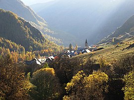 A view of the hamlet of Grande Serenne, in the commune of Saint-Paul-sur-Ubaye | ||
Location of Saint-Paul-sur-Ubaye  | ||
(2020–2026) Bernard Isoard[1] | | |
| Area 1 | 205.55 km2 (79.36 sq mi) | |
| Population (2021)[2] | 176 | |
| • Density | 0.86/km2 (2.2/sq mi) | |
| Time zone | UTC+01:00 (CET) | |
| • Summer (DST) | UTC+02:00 (CEST) | |
| INSEE/Postal code | 04193 /04530 | |
| 1 French Land Register data, which excludes lakes, ponds, glaciers > 1 km2 (0.386 sq mi or 247 acres) and river estuaries. | ||
Saint-Paul-sur-Ubaye (French pronunciation: [sɛ̃ pɔl syʁ ybaj], lit. "Saint Paul-on-Ubaye"; Vivaro-Alpine: Sant Pau d'Ubaia) is an alpine commune on the Italian border in the Alpes-de-Haute-Provence department in the Provence-Alpes-Côte d'Azur region in Southeastern France.
Geography
With an area of 205.55 km2 (79.36 sq mi), the commune of Saint-Paul-sur-Ubaye is the largest commune in the Alpes-de-Haute-Provence department by surface area. It is located in the department's northeastern part, on the departmental border with Hautes-Alpes. The source of the Ubaye is in the commune.[3]
Climate
| Climate data for St Paul (1981–2010 averages, 1978–2018 extremes): elevation 1908m | |||||||||||||
|---|---|---|---|---|---|---|---|---|---|---|---|---|---|
| Month | Jan | Feb | Mar | Apr | May | Jun | Jul | Aug | Sep | Oct | Nov | Dec | Year |
| Record high °C (°F) | 13.2 (55.8) | 14.6 (58.3) | 18.4 (65.1) | 22.6 (72.7) | 25.0 (77.0) | 27.2 (81.0) | 29.1 (84.4) | 30.0 (86.0) | 28.6 (83.5) | 24.8 (76.6) | 19.2 (66.6) | 11.9 (53.4) | 30.0 (86.0) |
| Mean daily maximum °C (°F) | 0.8 (33.4) | 2.8 (37.0) | 5.6 (42.1) | 7.8 (46.0) | 12.7 (54.9) | 17.1 (62.8) | 20.5 (68.9) | 20.1 (68.2) | 16.2 (61.2) | 11.6 (52.9) | 5.5 (41.9) | 0.8 (33.4) | 10.1 (50.2) |
| Daily mean °C (°F) | −4.1 (24.6) | −3.1 (26.4) | −0.1 (31.8) | 2.5 (36.5) | 6.9 (44.4) | 10.4 (50.7) | 13.2 (55.8) | 12.9 (55.2) | 9.5 (49.1) | 5.6 (42.1) | 0.5 (32.9) | −3.5 (25.7) | 4.2 (39.6) |
| Mean daily minimum °C (°F) | −8.9 (16.0) | −9.0 (15.8) | −5.8 (21.6) | −2.8 (27.0) | 1.1 (34.0) | 3.7 (38.7) | 5.8 (42.4) | 5.7 (42.3) | 2.8 (37.0) | −0.3 (31.5) | −4.4 (24.1) | −7.7 (18.1) | −1.6 (29.0) |
| Record low °C (°F) | −22.9 (−9.2) | −23.0 (−9.4) | −22.7 (−8.9) | −14.7 (5.5) | −11.6 (11.1) | −5.1 (22.8) | −2.3 (27.9) | −2.0 (28.4) | −6.7 (19.9) | −13.0 (8.6) | −20.2 (−4.4) | −23.0 (−9.4) | −23.0 (−9.4) |
| Average precipitation mm (inches) | 57.3 (2.26) | 45.1 (1.78) | 57.7 (2.27) | 83.0 (3.27) | 89.0 (3.50) | 93.3 (3.67) | 69.0 (2.72) | 75.4 (2.97) | 90.8 (3.57) | 111.0 (4.37) | 79.3 (3.12) | 72.0 (2.83) | 922.9 (36.33) |
| Source: Meteociel[4] | |||||||||||||
Demographics
| Year | Pop. | ±% p.a. |
|---|---|---|
| 1968 | 232 | — |
| 1975 | 221 | −0.69% |
| 1982 | 208 | −0.86% |
| 1990 | 198 | −0.61% |
| 1999 | 190 | −0.46% |
| 2009 | 229 | +1.88% |
| 2014 | 202 | −2.48% |
| 2020 | 177 | −2.18% |
| Source: INSEE[5] | ||
See also
- Ubaye Valley
- Communes of the Alpes-de-Haute-Provence department
References
- ^ "Répertoire national des élus: les maires" (in French). data.gouv.fr, Plateforme ouverte des données publiques françaises. 13 September 2022.
- ^ "Populations légales 2021" (in French). The National Institute of Statistics and Economic Studies. 28 December 2023.
- ^ Sandre. "Fiche cours d'eau - L'Ubaye (X04-0400)".
- ^ "Normales et records pour St Paul (04)". Meteociel. Retrieved 3 March 2024.
- ^ Population en historique depuis 1968, INSEE
Wikimedia Commons has media related to Saint-Paul-sur-Ubaye.
- v
- t
- e

- Aiglun
- Allemagne-en-Provence
- Allons
- Allos
- Angles
- Annot
- Archail
- Aubenas-les-Alpes
- Aubignosc
- Authon
- Auzet
- Banon
- Barcelonnettesubpr
- Barles
- Barras
- Barrême
- Bayons
- Beaujeu
- Beauvezer
- Bellaffaire
- Bevons
- Beynes
- Blieux
- Bras-d'Asse
- Braux
- La Brillanne
- Brunet
- Le Brusquet
- Le Caire
- Castellanesubpr
- Le Castellard-Mélan
- Le Castellet
- Castellet-lès-Sausses
- Céreste-en-Luberon
- Le Chaffaut-Saint-Jurson
- Champtercier
- Château-Arnoux-Saint-Auban
- Châteaufort
- Châteauneuf-Miravail
- Châteauneuf-Val-Saint-Donat
- Châteauredon
- Chaudon-Norante
- Clamensane
- Claret
- Clumanc
- Colmars
- La Condamine-Châtelard
- Corbières-en-Provence
- Cruis
- Curbans
- Curel
- Dauphin
- Demandolx
- Digne-les-Bainspref
- Draix
- Enchastrayes
- Entrages
- Entrepierres
- Entrevaux
- Entrevennes
- L'Escale
- Esparron-de-Verdon
- Estoublon
- Faucon-de-Barcelonnette
- Faucon-du-Caire
- Fontienne
- Forcalquiersubpr
- Le Fugeret
- Ganagobie
- La Garde
- Gigors
- Gréoux-les-Bains
- Hautes-Duyes
- L'Hospitalet
- Jausiers
- La Javie
- Lambruisse
- Lardiers
- Le Lauzet-Ubaye
- Limans
- Lurs
- Majastres
- Malijai
- Mallefougasse-Augès
- Mallemoisson
- Mane
- Manosque
- Marcoux
- Méailles
- Les Mées
- Melve
- Méolans-Revel
- Mézel
- Mirabeau
- Mison
- Montagnac-Montpezat
- Montclar
- Montfort
- Montfuron
- Montjustin
- Montlaux
- Montsalier
- Moriez
- La Motte-du-Caire
- Moustiers-Sainte-Marie
- La Mure-Argens
- Nibles
- Niozelles
- Noyers-sur-Jabron
- Les Omergues
- Ongles
- Oppedette
- Oraison
- La Palud-sur-Verdon
- Peipin
- Peyroules
- Peyruis
- Piégut
- Pierrerue
- Pierrevert
- Pontis
- Prads-Haute-Bléone
- Puimichel
- Puimoisson
- Quinson
- Redortiers
- Reillanne
- Revest-des-Brousses
- Revest-du-Bion
- Revest-Saint-Martin
- Riez
- La Robine-sur-Galabre
- La Rochegiron
- La Rochette
- Rougon
- Roumoules
- Saint-André-les-Alpes
- Saint-Benoît
- Sainte-Croix-à-Lauze
- Sainte-Croix-du-Verdon
- Saint-Étienne-les-Orgues
- Sainte-Tulle
- Saint-Geniez
- Saint-Jacques
- Saint-Jeannet
- Saint-Julien-d'Asse
- Saint-Julien-du-Verdon
- Saint-Jurs
- Saint-Laurent-du-Verdon
- Saint-Lions
- Saint-Maime
- Saint-Martin-de-Brômes
- Saint-Martin-les-Eaux
- Saint-Martin-lès-Seyne
- Saint-Michel-l'Observatoire
- Saint-Paul-sur-Ubaye
- Saint-Pierre
- Saint-Pons
- Saint-Vincent-sur-Jabron
- Salignac
- Saumane
- Sausses
- Selonnet
- Senez
- Seyne
- Sigonce
- Sigoyer
- Simiane-la-Rotonde
- Sisteron
- Soleilhas
- Sourribes
- Tartonne
- Thèze
- Thoard
- Thorame-Basse
- Thorame-Haute
- Les Thuiles
- Turriers
- Ubaye-Serre-Ponçon
- Ubraye
- Uvernet-Fours
- Vachères
- Valavoire
- Valbelle
- Val-de-Chalvagne
- Val-d'Oronaye
- Valensole
- Valernes
- Vaumeilh
- Venterol
- Verdaches
- Vergons
- Le Vernet
- Villars-Colmars
- Villemus
- Villeneuve
- Volonne
- Volx
- pref: prefecture
- subpr: subprefecture
 | This Alpes-de-Haute-Provence geographical article is a stub. You can help Wikipedia by expanding it. |
- v
- t
- e


