National Register of Historic Places listings in Traill County, North Dakota

This is a list of the National Register of Historic Places listings in Traill County, North Dakota.
This is intended to be a complete list of the properties and districts on the National Register of Historic Places in Traill County, North Dakota, United States. The locations of National Register properties and districts for which the latitude and longitude coordinates are included below, may be seen in a map.[1]
There are 22 properties and districts listed on the National Register in the county. Another 5 properties were once listed but have been removed.
Map all coordinates using OpenStreetMap
Download coordinates as:
- KML
- GPX (all coordinates)
- GPX (primary coordinates)
- GPX (secondary coordinates)
| Adams | Barnes | Benson | Billings | Bottineau | Bowman | Burke | Burleigh | Cass | Cavalier | Dickey | Divide | Dunn | Eddy | Emmons | Foster | Golden Valley | Grand Forks | Grant | Griggs | Hettinger | Kidder | LaMoure | Logan | McHenry | McIntosh | McKenzie | McLean | Mercer | Morton | Mountrail | Nelson | Oliver | Pembina | Pierce | Ramsey | Ransom | Renville | Richland | Rolette | Sargent | Sheridan | Sioux | Slope | Stark | Steele | Stutsman | Towner | Traill | Walsh | Ward | Wells | Williams |
This National Park Service list is complete through NPS recent listings posted July 19, 2024.[2]
Current listings
| [3] | Name on the Register | Image | Date listed[4] | Location | City or town | Description |
|---|---|---|---|---|---|---|
| 1 | Caledonia Bridge |  | February 27, 1997 (#97000188) | Unnamed county road across the Goose River, approximately 1 mile west of the Minnesota state line 47°27′26″N 96°53′03″W / 47.457222°N 96.884167°W / 47.457222; -96.884167 (Caledonia Bridge) | Caledonia | |
| 2 | Delchar Theater |  | November 14, 1985 (#85002831) | 20 W. Main St. 47°30′01″N 97°19′36″W / 47.500278°N 97.326667°W / 47.500278; -97.326667 (Delchar Theater) | Mayville | |
| 3 | Carl Ben Eielson House |  | April 11, 1977 (#77001031) | 405 8th St. 47°38′16″N 97°27′20″W / 47.637778°N 97.455556°W / 47.637778; -97.455556 (Carl Ben Eielson House) | Hatton | |
| 4 | Ellingson Farm District | Upload image | September 12, 1985 (#85002343) | 1 mile north and 2.5 miles west of Hillsboro 47°27′39″N 97°07′31″W / 47.460833°N 97.125278°W / 47.460833; -97.125278 (Ellingson Farm District) | Hillsboro | |
| 5 | First National Bank | | November 20, 1985 (#85002906) | 22 W. Main St. 47°30′01″N 97°19′35″W / 47.500278°N 97.326389°W / 47.500278; -97.326389 (First National Bank) | Mayville | |
| 6 | First State Bank of Buxton |  | February 14, 1978 (#78001995) | 423 Broadway St. 47°36′10″N 97°05′51″W / 47.602778°N 97.0975°W / 47.602778; -97.0975 (First State Bank of Buxton) | Buxton | |
| 7 | Goose River Bank |  | November 14, 1985 (#85002793) | 45 Main St., E. 47°30′00″N 97°19′29″W / 47.5°N 97.324722°W / 47.5; -97.324722 (Goose River Bank) | Mayville | |
| 8 | Grandins' Mayville Farm District | Upload image | November 19, 1985 (#85002905) | 2 Brunsdale, W. 47°30′12″N 97°20′02″W / 47.503333°N 97.333889°W / 47.503333; -97.333889 (Grandins' Mayville Farm District) | Mayville | |
| 9 | Great Northern Railway Depot |  | October 5, 1977 (#77001033) | Front St. 47°30′00″N 97°19′26″W / 47.5°N 97.323889°W / 47.5; -97.323889 (Great Northern Railway Depot) | Mayville | |
| 10 | Grinager Mercantile Building |  | November 20, 1985 (#85003354) | 37 Main St., E. 47°30′01″N 97°19′31″W / 47.500278°N 97.325278°W / 47.500278; -97.325278 (Grinager Mercantile Building) | Mayville | |
| 11 | Lucken Farm | Upload image | May 14, 1986 (#86001049) | North of Portland 47°31′33″N 97°22′09″W / 47.525833°N 97.369167°W / 47.525833; -97.369167 (Lucken Farm) | Portland | |
| 12 | Lura Building |  | November 14, 1985 (#85002794) | 29 W. Main St. 47°30′00″N 97°19′34″W / 47.5°N 97.326111°W / 47.5; -97.326111 (Lura Building) | Mayville | |
| 13 | Mayville Historic District | Upload image | November 19, 1985 (#85002904) | Roughly bounded by 3rd St., NE., 5th Ave., NE., Main St., E., and 3rd Ave., NE. and 2nd Ave., NE. 47°30′13″N 97°19′19″W / 47.503611°N 97.321944°W / 47.503611; -97.321944 (Mayville Historic District) | Mayville | |
| 14 | Mayville Public Library |  | April 11, 1977 (#77001034) | Center Ave., N. 47°30′04″N 97°19′33″W / 47.501111°N 97.325833°W / 47.501111; -97.325833 (Mayville Public Library) | Mayville | |
| 15 | Andres O. Ness House | Upload image | July 15, 1977 (#77001032) | Oak Ave. and 6th St. 47°38′14″N 97°27′44″W / 47.637222°N 97.462222°W / 47.637222; -97.462222 (Andres O. Ness House) | Hatton | |
| 16 | Norway Bridge |  | February 27, 1997 (#97000192) | Unnamed county road across the Goose River, approximately 6 miles east and 3 miles south of Mayville 47°27′26″N 97°11′55″W / 47.457222°N 97.198611°W / 47.457222; -97.198611 (Norway Bridge) | Mayville | |
| 17 | Amos and Lillie Plummer House | 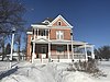 | January 4, 1996 (#95001488) | 306 W. Caledonia Ave. 47°24′11″N 97°03′58″W / 47.403056°N 97.066111°W / 47.403056; -97.066111 (Amos and Lillie Plummer House) | Hillsboro | |
| 18 | Col. William H. Robinson House |  | April 11, 1977 (#77001035) | 127 4th Ave., NE. 47°30′11″N 97°19′20″W / 47.503056°N 97.322222°W / 47.503056; -97.322222 (Col. William H. Robinson House) | Mayville | |
| 19 | Stomner House |  | October 11, 1979 (#79003728) | 32 3rd St., NE. 47°30′07″N 97°19′22″W / 47.501944°N 97.322778°W / 47.501944; -97.322778 (Stomner House) | Mayville | |
| 20 | Traill County Courthouse | 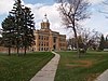 | November 25, 1980 (#80002928) | 114 W. Caledonia Ave. 47°24′13″N 97°03′48″W / 47.403611°N 97.063333°W / 47.403611; -97.063333 (Traill County Courthouse) | Hillsboro | |
| 21 | Union Block |  | November 20, 1985 (#85003353) | 21-25 Main St., W. 47°29′59″N 97°19′36″W / 47.499722°N 97.326667°W / 47.499722; -97.326667 (Union Block) | Mayville | |
| 22 | Viking Bridge | 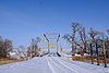 | February 27, 1997 (#97000190) | Unnamed county road across the Goose River, approximately 1 mile northwest of Portland 47°31′02″N 97°23′21″W / 47.517222°N 97.389167°W / 47.517222; -97.389167 (Viking Bridge) | Portland |
Former listings
| [3] | Name on the Register | Image | Date listed | Date removed | Location | City or town | Description |
|---|---|---|---|---|---|---|---|
| 1 | Blanchard Bridge | Upload image | February 27, 1997 (#97000189) | March 25, 2009 | Unnamed county road across the Elm River, approximately 0.5 miles (0.8 km) south of Blanchard, east of ND 18 47°20′23″N 97°12′59″W / 47.3397°N 97.2164°W / 47.3397; -97.2164 (Blanchard Bridge) | Blanchard | Was moved from location in August 2007.[5] |
| 2 | Goose River Bridge | Upload image | February 27, 1997 (#97000187) | March 25, 2009 | Unnamed county road across the Goose River, approximately 6 miles (9.7 km) east and 1 mile (1.6 km) north of Hillsboro 47°20′23″N 97°12′59″W / 47.3397°N 97.2164°W / 47.3397; -97.2164 (Goose River Bridge) | Hillsboro | |
| 3 | Porter Elliott Bridge | Upload image | February 27, 1997 (#97000193) | March 25, 2009 | Unnamed county road across the Sheyenne River, approximately 5 miles (8.0 km) east and 1 mile (1.6 km) north of Hillsboro 47°26′10″N 96°56′32″W / 47.4361°N 96.9422°W / 47.4361; -96.9422 (Porter Elliott Bridge) | Hillsboro | |
| 4 | Portland Park Bridge | Upload image | February 27, 1997 (#97000191) | September 23, 2004 | Across the S branch of the Goose River, unnamed co. rd., NE edge of Portland | Portland vicinity | |
| 5 | O.C. Sarles House | Upload image | March 12, 1985 (#85000562) | March 25, 2009 | 2nd Avenue and 3rd Street, northeast corner 47°24′24″N 97°03′25″W / 47.4067°N 97.0569°W / 47.4067; -97.0569 (O.C. Sarles House) | Hillsboro |
See also
Wikimedia Commons has media related to National Register of Historic Places in Traill County, North Dakota.
- List of National Historic Landmarks in North Dakota
- National Register of Historic Places listings in North Dakota
References
- ^ The latitude and longitude information provided in this table was derived originally from the National Register Information System, which has been found to be fairly accurate for about 99% of listings. Some locations in this table may have been corrected to current GPS standards.
- ^ National Park Service, United States Department of the Interior, "National Register of Historic Places: Weekly List Actions", retrieved July 19, 2024.
- ^ a b Numbers represent an alphabetical ordering by significant words. Various colorings, defined here, differentiate National Historic Landmarks and historic districts from other NRHP buildings, structures, sites or objects.
- ^ The eight-digit number below each date is the number assigned to each location in the National Register Information System database, which can be viewed by clicking the number.
- ^ "Sunsets numbered for historic 107-year-old bridge at Blanchard". Hillsboro Banner. August 10, 2007. Archived from the original on July 18, 2011. Retrieved April 3, 2009.
- v
- t
- e

by county
- Adams
- Barnes
- Benson
- Billings
- Bottineau
- Bowman
- Burke
- Burleigh
- Cass
- Cavalier
- Dickey
- Divide
- Dunn
- Eddy
- Emmons
- Foster
- Golden Valley
- Grand Forks
- Grant
- Griggs
- Hettinger
- Kidder
- LaMoure
- Logan
- McHenry
- McIntosh
- McKenzie
- McLean
- Mercer
- Morton
- Mountrail
- Nelson
- Oliver
- Pembina
- Pierce
- Ramsey
- Ransom
- Renville
- Richland
- Rolette
- Sargent
- Sheridan
- Sioux
- Slope
- Stark
- Steele
- Stutsman
- Towner
- Traill
- Walsh
- Ward
- Wells
- Williams
 Category
 NRHP Portal


Municipalities and communities of Traill County, North Dakota, United States | ||
|---|---|---|
County seat: Hillsboro | ||
| Cities |  | |
| CDPs | ||
| Unincorporated communities | ||
| Footnotes | ‡This populated place also has portions in an adjacent county or counties | |
| ||


