National Register of Historic Places listings in The Highlands, Louisville, Kentucky
Map all coordinates using OpenStreetMap
Download coordinates as:
- KML
- GPX (all coordinates)
- GPX (primary coordinates)
- GPX (secondary coordinates)
This is a list of properties and historic districts on the National Register of Historic Places in The Highlands, Louisville, Kentucky. The table below includes 32 listings in the following neighborhoods:
- Belknap
- Bonnycastle
- Cherokee Triangle
- Deer Park
- Hawthorne
- Hayfield Dundee
- Highlands-Douglass
- Irish Hill
- Original Highlands
- Tyler Park
Latitude and longitude coordinates of the sites listed on this page may be displayed in a map or exported in several formats by clicking on one of the links in the box below the map to the right.[1]
National Register sites elsewhere in Jefferson County are listed separately.
This National Park Service list is complete through NPS recent listings posted June 28, 2024.[2]
Current listings
| [3] | Name on the Register | Image | Date listed[4] | Location | Neighborhood | Description |
|---|---|---|---|---|---|---|
| 1 | Leslie V. Abbott House |  | July 30, 2013 (#13000558) | 2401 Newburg Rd. 38°12′49″N 85°42′01″W / 38.213611°N 85.700278°W / 38.213611; -85.700278 (Leslie V. Abbott House) | Belknap | |
| 2 | Willam R. Belknap School | 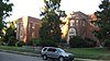 | August 12, 1982 (#82002706) | 1800 Sils Ave. 38°13′19″N 85°41′23″W / 38.221944°N 85.689722°W / 38.221944; -85.689722 (Willam R. Belknap School) | Belknap | |
| 3 | Bullock-Clifton House |  | May 6, 1982 (#82002707) | 1824 Rosedale Ave. 38°13′27″N 85°42′15″W / 38.224167°N 85.704167°W / 38.224167; -85.704167 (Bullock-Clifton House) | Deer Park | |
| 4 | Calvary Evangelical Lutheran Church | Upload image | March 13, 2017 (#100000740) | 1838 Bardstown Rd. 38°13′39″N 85°41′59″W / 38.227517°N 85.699731°W / 38.227517; -85.699731 (Calvary Evangelical Lutheran Church) | ||
| 5 | John B. Castleman Monument |  | July 17, 1997 (#97000690) | Junction of Cherokee Rd. and Cherokee Parkway 38°14′07″N 85°42′45″W / 38.235278°N 85.712500°W / 38.235278; -85.712500 (John B. Castleman Monument) | Cherokee Triangle | |
| 6 | Cave Hill Cemetery |  | December 11, 1979 (#79000999) | 701 Baxter Ave. 38°14′44″N 85°42′56″W / 38.245556°N 85.715556°W / 38.245556; -85.715556 (Cave Hill Cemetery) | Cherokee Triangle | |
| 7 | Cave Hill National Cemetery |  | September 3, 1998 (#98001133) | 701 Baxter Ave. 38°14′56″N 85°43′20″W / 38.248889°N 85.722222°W / 38.248889; -85.722222 (Cave Hill National Cemetery) | Cherokee Triangle | |
| 8 | Cherokee Triangle Area Residential District |  | June 30, 1976 (#76000902) | Roughly bounded by Bardstown Rd., Sherwood Ave., and Broadway, east to the junction of Grinstead Dr. and Cherokee Parkway 38°14′22″N 85°42′56″W / 38.239444°N 85.715556°W / 38.239444; -85.715556 (Cherokee Triangle Area Residential District) | Cherokee Triangle | |
| 9 | Commodore Apartment Building |  | April 29, 1982 (#82002709) | 2140 Bonnycastle Ave. 38°13′58″N 85°42′03″W / 38.232778°N 85.700833°W / 38.232778; -85.700833 (Commodore Apartment Building) | Bonnycastle | |
| 10 | Engelhard House |  | December 5, 1980 (#80001599) | 1080 Baxter Ave. 38°14′15″N 85°43′21″W / 38.237500°N 85.722500°W / 38.237500; -85.722500 (Engelhard House) | Tyler Park | |
| 11 | Farmington |  | October 18, 1972 (#72000536) | 3033 Bardstown Rd. 38°12′53″N 85°40′05″W / 38.214722°N 85.668056°W / 38.214722; -85.668056 (Farmington) | Hawthorne | |
| 12 | Nicholas Finzer House |  | May 9, 1979 (#79001004) | 1212 Hull St. 38°14′53″N 85°43′39″W / 38.248194°N 85.727500°W / 38.248194; -85.727500 (Nicholas Finzer House) | Irish Hill | |
| 13 | Hayfield | Upload image | August 19, 1980 (#80001600) | 1809 Tyler Lane 38°12′28″N 85°41′10″W / 38.207778°N 85.686111°W / 38.207778; -85.686111 (Hayfield) | Hayfield Dundee | |
| 14 | Highlands Historic District |  | February 11, 1983 (#83002680) | Roughly bounded by Barrett Ave., Eastern Parkway, Bardstown Road, and Fernwood, Woodbourne, Ellerbee, and Sherwood Aves. 38°14′22″N 85°43′36″W / 38.239444°N 85.726667°W / 38.239444; -85.726667 (Highlands Historic District) | Original Highlands | |
| 15 | Howard-Gettys House | 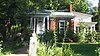 | February 8, 1978 (#78001356) | 1226 Bates Ct. 38°13′45″N 85°43′24″W / 38.229167°N 85.723333°W / 38.229167; -85.723333 (Howard-Gettys House) | Tyler Park | |
| 16 | Humphrey-McMeekin House |  | March 20, 1986 (#86000475) | 2240 Douglass Boulevard 38°13′42″N 85°41′09″W / 38.228333°N 85.685833°W / 38.228333; -85.685833 (Humphrey-McMeekin House) | Highlands-Douglass | |
| 17 | Irish Hill Historic District | Upload image | April 23, 2024 (#100010253) | Roughly bounded by I-64, Lexington Road, Bishop Street, and Cave Hill Cemetery 38°15′06″N 85°43′18″W / 38.2517°N 85.7217°W / 38.2517; -85.7217 (Irish Hill Historic District) | Louisville | |
| 18 | Kentucky Home School for Girls | Upload image | August 2, 2017 (#100001422) | 2305 Douglass Blvd. 38°13′48″N 85°41′09″W / 38.230105°N 85.685916°W / 38.230105; -85.685916 (Kentucky Home School for Girls) | ||
| 19 | Klotz Confectionary Company | Upload image | February 11, 2016 (#16000007) | 731 Brent St. 38°14′35″N 85°44′05″W / 38.242953°N 85.734666°W / 38.242953; -85.734666 (Klotz Confectionary Company) | ||
| 20 | Nelson Distillery Warehouse |  | June 27, 2014 (#14000423) | 100 Distillery Commons Dr. 38°15′00″N 85°43′23″W / 38.2500°N 85.723°W / 38.2500; -85.723 (Nelson Distillery Warehouse) | Irish Hill | Now the Distillery Commons. |
| 21 | Rose Hill | 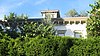 | December 3, 1980 (#80001616) | 1835 Hampden Ct. 38°13′43″N 85°41′54″W / 38.228611°N 85.698333°W / 38.228611; -85.698333 (Rose Hill) | Highlands-Douglass | |
| 22 | Saint Francis of Assisi Complex |  | May 29, 1987 (#87000850) | 1960 Bardstown Rd. 38°13′33″N 85°41′52″W / 38.225833°N 85.697778°W / 38.225833; -85.697778 (Saint Francis of Assisi Complex) | Deer Park | |
| 23 | St. James Roman Catholic Church, Rectory, and School |  | March 1, 1982 (#82002722) | 1430 Bardstown Rd., 1826 Edenside Ave, and 1818 Edenside Ave. 38°13′57″N 85°42′39″W / 38.232500°N 85.710833°W / 38.232500; -85.710833 (St. James Roman Catholic Church, Rectory, and School) | Tyler Park | |
| 24 | Valentine Schneikert House | 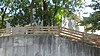 | April 17, 1986 (#86000848) | 1234 Lexington Rd. 38°14′58″N 85°43′38″W / 38.249444°N 85.727361°W / 38.249444; -85.727361 (Valentine Schneikert House) | Irish Hill | |
| 25 | Schuster Building |  | March 19, 1980 (#80001618) | 1500-1512 Bardstown Rd. 38°13′54″N 85°42′32″W / 38.231667°N 85.708889°W / 38.231667; -85.708889 (Schuster Building) | Deer Park | |
| 26 | Steam Engine Company No. 11 |  | November 7, 1980 (#80001623) | 1122 Rogers St. 38°14′45″N 85°43′38″W / 38.245833°N 85.727222°W / 38.245833; -85.727222 (Steam Engine Company No. 11) | Irish Hill | |
| 27 | Steam Engine Company No. 20 | 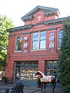 | November 7, 1980 (#80001626) | 1330 Bardstown Rd. 38°14′04″N 85°42′51″W / 38.234444°N 85.714167°W / 38.234444; -85.714167 (Steam Engine Company No. 20) | Tyler Park | |
| 28 | Steam Engine Company No. 20 |  | November 7, 1980 (#80004498) | 1735 Bardstown Rd. 38°13′45″N 85°42′06″W / 38.229167°N 85.701667°W / 38.229167; -85.701667 (Steam Engine Company No. 20) | Bonnycastle | |
| 29 | Struss House | Upload image | November 7, 2003 (#03001112) | 1920 Winston Ave. 38°12′55″N 85°41′09″W / 38.215139°N 85.685833°W / 38.215139; -85.685833 (Struss House) | Hayfield Dundee | |
| 30 | Union Monument in Louisville |  | July 17, 1997 (#97000687) | 701 Baxter Ave. 38°14′54″N 85°43′20″W / 38.248333°N 85.722222°W / 38.248333; -85.722222 (Union Monument in Louisville) | Irish Hill | Cave Hill Cemetery, junction of Payne St. and Lexington Rd. |
| 31 | David Wilson House | 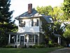 | March 26, 1987 (#87000511) | 2215 Carolina Ave. 38°13′46″N 85°41′02″W / 38.229306°N 85.683889°W / 38.229306; -85.683889 (David Wilson House) | Highlands-Douglass | |
| 32 | Woodbourne House |  | February 7, 2008 (#08000008) | 2024 Woodford Pl. 38°13′33″N 85°41′38″W / 38.225833°N 85.693889°W / 38.225833; -85.693889 (Woodbourne House) | Highlands-Douglass |
Former listing
| [3] | Name on the Register | Image | Date listed | Date removed | Location | Neighborhood | Description |
|---|---|---|---|---|---|---|---|
| 1 | August Bloedner Monument |  | July 17, 1997 (#97000688) | November 19, 2010 | 701 Baxter Ave. 38°14′54″N 85°43′19″W / 38.248333°N 85.721944°W / 38.248333; -85.721944 (August Bloedner Monument) | Cherokee Triangle | Formerly in the Cave Hill Cemetery, junction of Payne St. and Lexington Rd. Now located at the Frazier History Museum. Delisted due to relocation of the monument. |
See also
- National Register of Historic Places listings in Jefferson County, Kentucky
- List of National Historic Landmarks in Kentucky
- List of attractions and events in the Louisville metropolitan area
References
- ^ The latitude and longitude information provided in this table was derived originally from the National Register Information System, which has been found to be fairly accurate for about 99% of listings. Some locations in this table may have been corrected to current GPS standards.
- ^ National Park Service, United States Department of the Interior, "National Register of Historic Places: Weekly List Actions", retrieved June 28, 2024.
- ^ a b Numbers represent an alphabetical ordering by significant words. Various colorings, defined here, differentiate National Historic Landmarks and historic districts from other NRHP buildings, structures, sites or objects.
- ^ The eight-digit number below each date is the number assigned to each location in the National Register Information System database, which can be viewed by clicking the number.
- v
- t
- e
- List of U.S. National Historic Landmarks by state:
- Alabama
- Alaska
- Arizona
- Arkansas
- California
- Colorado
- Connecticut
- Delaware
- Florida
- Georgia
- Hawaii
- Idaho
- Illinois
- Indiana
- Iowa
- Kansas
- Kentucky
- Louisiana
- Maine
- Maryland
- Massachusetts
- Michigan
- Minnesota
- Mississippi
- Missouri
- Montana
- Nebraska
- Nevada
- New Hampshire
- New Jersey
- New Mexico
- New York
- North Carolina
- North Dakota
- Ohio
- Oklahoma
- Oregon
- Pennsylvania
- Rhode Island
- South Carolina
- South Dakota
- Tennessee
- Texas
- Utah
- Vermont
- Virginia
- Washington
- West Virginia
- Wisconsin
- Wyoming
 National Register of Historic Places portal
 Category


