National Register of Historic Places listings in Summit County, Utah

This is a list of the National Register of Historic Places listings in Summit County, Utah.
This is intended to be a complete list of the properties and districts on the National Register of Historic Places in Summit County, Utah, United States. Latitude and longitude coordinates are provided for many National Register properties and districts; these locations may be seen together in a map.[1]
There are 112 properties and districts listed on the National Register in the county. Another 3 sites in the county were once listed, but have since been removed.
Most of the listings are in Park City. Most of these are mining era houses dating from 1872 to 1929; a 1984 study identified nearly 150 houses of Park City's mining era, of which 104 were either listed or deemed eligible for listing.[2]
The study described the importance of this collection as:
Park City's houses are the largest and best preserved group of residential buildings in a metal mining town in Utah. As such, they provide the most complete documentation of the residential character of mining towns of that period - their settlement patterns, building materials and techniques, and socio-economic make-up. Most of the houses being nominated are small, modest cottages which represent the common folk who made up the majority of the working element of the town, and provide a direct contrast to the majestic houses and large commercial buildings constructed in Salt Lake City for many of the mine owners and officials. The Park City houses are architecturally significant as the largest and best preserved collection of nineteenth and early twentieth century frame houses in Utah; the vast majority of contemporary houses having been constructed of adobe, stone or brick. Documentation of Park City's house types, construction techniques, and building materials has contributed to the understanding of a significant aspect of Utah's architectural development, the late nineteenth century mining community.[2]

These included many examples of each of three main types of homes among its mining era housing. In 1984 there were 78 extant frame "T/L cottage" or cross-wing type houses in Park City, 17 of which were listed. Is a T/L cottage one with a T-shaped or L-shaped plan? These include House at 463 Park Ave. and the Charles Meadowcroft House; a large example is the Dr. William Bardsley House. How many were "T/L plan by addition"? There also are a few "L-plan by addition" houses including Alfred Lindorff House.

The second type is the frame pyramid house. In 1984, there were 69 surviving pyramid houses, 28 of which were nominated for listing. Of these, 11 were true pyramid houses, including the House at 343 Park Avenue, and 17 were variants.

The third type is the hall and parlor house, of which 76 survived and 22 were nominated, including the Samuel D. Walker House, which is now a two-story example. The Burt Kimball House was a one-story example, was listed but may not have survived. It was the earliest house type to be built in Park City.
A less common type is the shotgun house: fewer than 10 examples exist, of which three, including the Frank Hansen House and the House at 1101 Norfolk Avenue, were listed or deemed eligible.
Map all coordinates using OpenStreetMap
Download coordinates as:
- KML
- GPX (all coordinates)
- GPX (primary coordinates)
- GPX (secondary coordinates)
This National Park Service list is complete through NPS recent listings posted July 12, 2024.[3]
Current listings
| [4] | Name on the Register[5] | Image | Date listed[6] | Location | City or town | Description |
|---|---|---|---|---|---|---|
| 1 | Thomas L. Allen House | 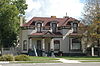 | July 23, 1982 (#82004161) | 98 N. Main St. 40°55′08″N 111°23′55″W / 40.918889°N 111.398611°W / 40.918889; -111.398611 (Thomas L. Allen House) | Coalville | |
| 2 | Archie Creek Camp | Upload image | January 5, 2016 (#15000958) | Address restricted[7] | Robertson, Wyoming vicinity | Railroad tie-cutting lumber camp of 1890s to 1930s. |
| 3 | William Austin House |  | July 11, 1984 (#84002226) | 247 Ontario Ave. 40°38′32″N 111°29′32″W / 40.642222°N 111.492222°W / 40.642222; -111.492222 (William Austin House) | Park City | |
| 4 | Dr. William Bardsley House |  | May 26, 1994 (#94000531) | 517 Park Ave. 40°38′39″N 111°29′47″W / 40.644167°N 111.496389°W / 40.644167; -111.496389 (Dr. William Bardsley House) | Park City | |
| 5 | Charles Barnes House |  | July 12, 1984 (#84002230) | 413 Ontario Ave. 40°38′38″N 111°29′34″W / 40.643889°N 111.492778°W / 40.643889; -111.492778 (Charles Barnes House) | Park City | |
| 6 | Richard Barrett House |  | July 11, 1984 (#84002238) | 36 Prospect Ave. 40°38′21″N 111°29′35″W / 40.639167°N 111.493056°W / 40.639167; -111.493056 (Richard Barrett House) | Park City | |
| 7 | George J. Barry House |  | July 12, 1984 (#84002239) | 250 Grant Ave. 40°38′31″N 111°29′36″W / 40.641944°N 111.493333°W / 40.641944; -111.493333 (George J. Barry House) | Park City | |
| 8 | Thomas and Jane Beech House |  | September 7, 2001 (#01000958) | 47 W. 50 South 40°54′53″N 111°23′53″W / 40.914722°N 111.398056°W / 40.914722; -111.398056 (Thomas and Jane Beech House) | Coalville | |
| 9 | Ellsworth J. Beggs House |  | July 11, 1984 (#84002240) | 703 Park Ave. 40°38′48″N 111°29′52″W / 40.646667°N 111.497778°W / 40.646667; -111.497778 (Ellsworth J. Beggs House) | Park City | |
| 10 | Annie Birch House |  | October 22, 1984 (#84000163) | Approximately 900 S. West Hoytsville Rd., off I-80 40°53′12″N 111°23′59″W / 40.886667°N 111.399722°W / 40.886667; -111.399722 (Annie Birch House) | Hoytsville | |
| 11 | Bogan Boarding House |  | October 22, 1984 (#84000154) | 221 Main St. 40°38′29″N 111°29′37″W / 40.641389°N 111.493611°W / 40.641389; -111.493611 (Bogan Boarding House) | Park City | |
| 12 | Boyden Block |  | February 6, 2009 (#09000019) | 2 S. Main St. 40°54′59″N 111°23′55″W / 40.91648°N 111.39861°W / 40.91648; -111.39861 (Boyden Block) | Coalville | |
| 13 | John Boyden House |  | February 11, 1982 (#82004162) | 47 W. Center St. 40°54′53″N 111°23′53″W / 40.914722°N 111.398056°W / 40.914722; -111.398056 (John Boyden House) | Coalville | |
| 14 | Otis L. Brown House | Upload image | July 11, 1984 (#84002241) | 713 Woodside Ave. 40°38′47″N 111°29′54″W / 40.646389°N 111.498333°W / 40.646389; -111.498333 (Otis L. Brown House) | Park City | |
| 15 | John W. Buck House |  | July 12, 1984 (#84002242) | 1110 Woodside Ave. 40°39′01″N 111°30′04″W / 40.650278°N 111.501111°W / 40.650278; -111.501111 (John W. Buck House) | Park City | |
| 16 | William Campbell House | Upload image | July 11, 1984 (#84002243) | 164 Norfolk Ave. 40°38′26″N 111°29′43″W / 40.640556°N 111.495278°W / 40.640556; -111.495278 (William Campbell House) | Park City | |
| 17 | Benedictus Carling House |  | July 12, 1984 (#84002244) | 660 Rossie Hill Dr. 40°38′40″N 111°29′16″W / 40.644444°N 111.487778°W / 40.644444; -111.487778 (Benedictus Carling House) | Park City | |
| 18 | James Cassidy House |  | July 11, 1984 (#84002245) | 33 King Rd. 40°38′22″N 111°29′39″W / 40.639444°N 111.494167°W / 40.639444; -111.494167 (James Cassidy House) | Park City | |
| 19 | James Cavanaugh House |  | July 12, 1984 (#84002246) | 564 Woodside Ave. 40°38′41″N 111°29′52″W / 40.644829°N 111.497875°W / 40.644829; -111.497875 (James Cavanaugh House) | Park City | Pyramid house |
| 20 | Peter Clark House |  | July 11, 1984 (#84002247) | 1135 Park Ave. 40°39′02″N 111°30′04″W / 40.650556°N 111.501111°W / 40.650556; -111.501111 (Peter Clark House) | Park City | |
| 21 | David F. and Elizabeth Condon House |  | July 12, 1984 (#84002248) | 1304 Park Ave. 40°39′10″N 111°30′08″W / 40.652778°N 111.502222°W / 40.652778; -111.502222 (David F. and Elizabeth Condon House) | Park City | |
| 22 | John F. Cunningham House |  | July 11, 1984 (#84002249) | 606 Park Ave. 40°38′45″N 111°29′48″W / 40.645833°N 111.496667°W / 40.645833; -111.496667 (John F. Cunningham House) | Park City | |
| 23 | John Diem House |  | October 22, 1984 (#84000155) | 401 Park Ave. 40°38′35″N 111°29′44″W / 40.643056°N 111.495556°W / 40.643056; -111.495556 (John Diem House) | Park City | |
| 24 | Doggy Door Tie Cutter Cabin | Upload image | July 18, 2014 (#14000431) | Address restricted[8] | Wasatch National Forest | |
| 25 | John Doyle House |  | February 6, 1986 (#86000162) | 339 Park Ave. 40°38′32″N 111°29′35″W / 40.642222°N 111.493056°W / 40.642222; -111.493056 (John Doyle House) | Park City | |
| 26 | Durkin Boarding House |  | July 12, 1984 (#84002253) | 176 Main St. 40°38′27″N 111°29′35″W / 40.640833°N 111.493056°W / 40.640833; -111.493056 (Durkin Boarding House) | Park City | |
| 27 | Joseph Durkin House |  | July 11, 1984 (#84002262) | 22 Prospect Ave. 40°38′22″N 111°29′34″W / 40.639444°N 111.492778°W / 40.639444; -111.492778 (Joseph Durkin House) | Park City | |
| 28 | Echo Canyon Breastworks |  | October 27, 1988 (#88001942) | Address Restricted[8] | Echo | |
| 29 | Echo Church and School |  | January 5, 1989 (#88003000) | Temple Ln. 40°58′43″N 111°26′25″W / 40.978611°N 111.440278°W / 40.978611; -111.440278 (Echo Church and School) | Echo | |
| 30 | Echo Post Office |  | August 14, 2003 (#03000159) | 3455 S. Echo Rd. 40°58′49″N 111°26′37″W / 40.980278°N 111.443611°W / 40.980278; -111.443611 (Echo Post Office) | Echo | |
| 31 | Echo School |  | August 1, 1997 (#97000805) | 3441 S. Echo Rd. 40°58′43″N 111°26′37″W / 40.978611°N 111.443611°W / 40.978611; -111.443611 (Echo School) | Echo | |
| 32 | Ecker Hill Ski Jump |  | June 4, 1986 (#86001251) | Off I-80 40°44′38″N 111°34′36″W / 40.743889°N 111.576667°W / 40.743889; -111.576667 (Ecker Hill Ski Jump) | Snyderville | |
| 33 | Peter Farthelos House |  | July 12, 1984 (#84002267) | 1150 Park Ave. 40°39′03″N 111°30′03″W / 40.650833°N 111.500833°W / 40.650833; -111.500833 (Peter Farthelos House) | Park City | |
| 34 | Mike Frkovich House |  | July 12, 1984 (#84002270) | 162 Daly Ave. 40°38′16″N 111°29′42″W / 40.637778°N 111.495°W / 40.637778; -111.495 (Mike Frkovich House) | Park City | |
| 35 | Glenwood Cemetery |  | May 1, 1996 (#96000436) | Silver King Dr., approximately 0.5 miles (0.80 km) north of Park City Ski Resort 40°39′16″N 111°30′40″W / 40.654444°N 111.511111°W / 40.654444; -111.511111 (Glenwood Cemetery) | Park City | |
| 36 | Levins D. Gray House |  | July 12, 1984 (#84002272) | 355 Ontario Ave. 40°38′37″N 111°29′37″W / 40.643488°N 111.493669°W / 40.643488; -111.493669 (Levins D. Gray House) | Park City | Pyramid house, with variation of inset porch. |
| 37 | John Grix Cabin |  | March 8, 1997 (#97000226) | 0.25 miles (0.40 km) west of State Route 150, approximately 20 miles (32 km) northeast of Kamas 40°40′49″N 110°57′35″W / 40.680278°N 110.959722°W / 40.680278; -110.959722 (John Grix Cabin) | Kamas | |
| 38 | Frank Hansen House |  | July 12, 1984 (#84002274) | 1025 Park Ave. 40°38′57″N 111°30′01″W / 40.649167°N 111.500278°W / 40.649167; -111.500278 (Frank Hansen House) | Park City | |
| 39 | Joseph D. Harris House |  | July 12, 1984 (#84002277) | 959 Park Ave. 40°38′56″N 111°29′59″W / 40.648889°N 111.499722°W / 40.648889; -111.499722 (Joseph D. Harris House) | Park City | |
| 40 | William H. Harris House |  | July 12, 1984 (#84002279) | 39 King Rd. 40°38′22″N 111°29′37″W / 40.639444°N 111.493611°W / 40.639444; -111.493611 (William H. Harris House) | Park City | |
| 41 | Harry W. Haumann House |  | July 12, 1984 (#84002281) | 939 Empire Ave. 40°38′52″N 111°30′04″W / 40.647778°N 111.501111°W / 40.647778; -111.501111 (Harry W. Haumann House) | Park City | |
| 42 | Verner O. Hewlett Ranch House | Upload image | May 23, 1985 (#85001133) | Off State Route 35 40°33′14″N 111°09′51″W / 40.553869°N 111.164055°W / 40.553869; -111.164055 (Verner O. Hewlett Ranch House) | Woodland | Log house, in historic Stewart Ranch spanning the Provo River. Seven other buildings across the river are Wasatch County listings |
| 43 | Henry M. Hinsdill House |  | July 12, 1984 (#84002283) | 662 Norfolk Ave. 40°38′46″N 111°29′55″W / 40.646111°N 111.498611°W / 40.646111; -111.498611 (Henry M. Hinsdill House) | Park City | |
| 44 | Samuel Holman House | Upload image | July 12, 1984 (#84002290) | 307 Norfolk Ave. 40°38′30″N 111°29′47″W / 40.641667°N 111.496389°W / 40.641667; -111.496389 (Samuel Holman House) | Park City | |
| 45 | House at 62 Daly Avenue | Upload image | July 12, 1984 (#84002304) | 62 Daly Ave. 40°38′20″N 111°29′39″W / 40.638889°N 111.494167°W / 40.638889; -111.494167 (House at 62 Daly Avenue) | Park City | |
| 46 | House at 555 Deer Valley Road |  | July 12, 1984 (#84002299) | 555 Deer Valley Rd. 40°38′43″N 111°29′28″W / 40.645366°N 111.490975°W / 40.645366; -111.490975 (House at 555 Deer Valley Road) | Park City | Pyramid house built around 1895. |
| 47 | House at 577 Deer Valley Road | Upload image | July 12, 1984 (#84002301) | 577 Deer Valley Rd. 40°38′44″N 111°29′23″W / 40.645556°N 111.489722°W / 40.645556; -111.489722 (House at 577 Deer Valley Road) | Park City | |
| 48 | House at 1101 Norfolk Avenue |  | July 12, 1984 (#84002294) | 1101 Norfolk Ave. 40°38′58″N 111°30′10″W / 40.649306°N 111.502639°W / 40.649306; -111.502639 (House at 1101 Norfolk Avenue) | Park City | |
| 49 | House at 343 Park Avenue |  | July 12, 1984 (#84002297) | 343 Park Ave. 40°38′33″N 111°29′43″W / 40.6425°N 111.495278°W / 40.6425; -111.495278 (House at 343 Park Avenue) | Park City | |
| 50 | House at 463 Park Ave. |  | May 28, 1999 (#99000620) | 463 Park Ave. 40°38′34″N 111°29′45″W / 40.642778°N 111.495833°W / 40.642778; -111.495833 (House at 463 Park Ave.) | Park City | |
| 51 | House at 101 Prospect |  | October 22, 1984 (#84000156) | 101 Prospect Ave. 40°38′17″N 111°29′34″W / 40.638056°N 111.492778°W / 40.638056; -111.492778 (House at 101 Prospect) | Park City | |
| 52 | House at 622 Rossie Hill Drive | Upload image | July 12, 1984 (#84002308) | 622 Rossie Hill Dr. 40°38′41″N 111°29′21″W / 40.644644°N 111.489056°W / 40.644644; -111.489056 (House at 622 Rossie Hill Drive) | Park City | T/L cottage |
| 53 | Howe Flume Historic District |  | December 12, 1978 (#78002695) | Northeast of Oakley in Wasatch National Forest 40°49′50″N 110°49′58″W / 40.830556°N 110.832778°W / 40.830556; -110.832778 (Howe Flume Historic District) | Oakley | |
| 54 | Samuel P. Hoyt House |  | April 19, 1982 (#82004163) | 285 Hoyt Ln. 40°52′18″N 111°23′04″W / 40.871667°N 111.384444°W / 40.871667; -111.384444 (Samuel P. Hoyt House) | Hoytsville | |
| 55 | IOOF Relief Home |  | July 12, 1984 (#84002311) | 232 Woodside Ave. 40°38′27″N 111°29′41″W / 40.640833°N 111.494722°W / 40.640833; -111.494722 (IOOF Relief Home) | Park City | |
| 56 | Joseph J. Jenkins House |  | July 12, 1984 (#84002315) | 27 Prospect Ave. 40°38′19″N 111°29′34″W / 40.638611°N 111.492778°W / 40.638611; -111.492778 (Joseph J. Jenkins House) | Park City | |
| 57 | Carl G. Johnson House | Upload image | April 12, 1984 (#84002318) | 147 Grant Ave. 40°38′28″N 111°29′38″W / 40.641029°N 111.493853°W / 40.641029; -111.493853 (Carl G. Johnson House) | Park City | Hall and parlor plan house built around 1885. |
| 58 | Elizabeth M. Jones House |  | July 12, 1984 (#84002322) | 412 Marsac Ave. 40°38′38″N 111°29′35″W / 40.643889°N 111.493056°W / 40.643889; -111.493056 (Elizabeth M. Jones House) | Park City | |
| 59 | Kimball Stage Stop |  | April 16, 1971 (#71000855) | 318 Bitner Rd. 40°43′24″N 111°31′02″W / 40.72346°N 111.51726°W / 40.72346; -111.51726 (Kimball Stage Stop) | Park City | |
| 60 | Burt Kimball House |  | July 12, 1984 (#84002325) | 817 Park Ave. 40°38′51″N 111°29′55″W / 40.6475°N 111.498611°W / 40.6475; -111.498611 (Burt Kimball House) | Park City | |
| 61 | Ernest Lynn Kimball House |  | July 12, 1984 (#84002329) | 911 Empire Ave. 40°38′50″N 111°30′03″W / 40.647222°N 111.500833°W / 40.647222; -111.500833 (Ernest Lynn Kimball House) | Park City | |
| 62 | LDS Park City Meetinghouse |  | May 22, 1978 (#78002696) | 424 Park Ave. 40°38′35″N 111°29′43″W / 40.643056°N 111.495278°W / 40.643056; -111.495278 (LDS Park City Meetinghouse) | Park City | |
| 63 | Alfred Lindorff House |  | July 12, 1984 (#84002331) | 40 Sampson Ave. 40°38′25″N 111°29′45″W / 40.640278°N 111.495833°W / 40.640278; -111.495833 (Alfred Lindorff House) | Park City | |
| 64 | Little Bell Mine Site | Upload image | November 27, 2023 (#100009571) | 1 mile (1.6 km) w. of jct. SR-224 and Twisted Branch Rd Coordinates missing | Park City vicinity | |
| 65 | Oscar F. Lyons House |  | July 14, 1983 (#83003192) | 5412 N. Wooden Shoe Rd. 40°43′24″N 111°20′25″W / 40.723472°N 111.340139°W / 40.723472; -111.340139 (Oscar F. Lyons House) | Peoa | |
| 66 | Marsac Elementary School |  | April 1, 1985 (#85000815) | 431 Marsac Ave. 40°38′39″N 111°29′38″W / 40.644167°N 111.493889°W / 40.644167; -111.493889 (Marsac Elementary School) | Park City | |
| 67 | John Maycock Cabin |  | March 11, 2005 (#05000187) | Approximately 20 miles (32 km) northeast of Kamas and 0.5 miles (0.80 km) west of State Route 150 in the Wasatch-Cache National Forest 40°40′50″N 110°57′27″W / 40.680556°N 110.9575°W / 40.680556; -110.9575 (John Maycock Cabin) | Kamas | |
| 68 | William and Elizabeth McMichael House |  | December 31, 1998 (#98001576) | 1259 S. West Hoytsville Rd. 40°51′49″N 111°23′50″W / 40.863611°N 111.397222°W / 40.863611; -111.397222 (William and Elizabeth McMichael House) | Hoytsville | |
| 69 | McPolin Farmstead |  | August 14, 2003 (#03000155) | 3000 N. State Route 224 40°40′38″N 111°31′36″W / 40.677222°N 111.526667°W / 40.677222; -111.526667 (McPolin Farmstead) | Park City | |
| 70 | Charles Meadowcroft House |  | July 12, 1984 (#84002333) | 951 Woodside Ave. 40°38′55″N 111°30′00″W / 40.648611°N 111.5°W / 40.648611; -111.5 (Charles Meadowcroft House) | Park City | |
| 71 | Byron T. Mitchell House |  | May 18, 1984 (#84002336) | State Route 32 and State Route 35 40°36′39″N 111°16′48″W / 40.610833°N 111.28°W / 40.610833; -111.28 (Byron T. Mitchell House) | Francis | |
| 72 | Jesse Morgan House |  | July 12, 1984 (#84002338) | 1027 Woodside Ave. 40°38′57″N 111°30′03″W / 40.649167°N 111.500833°W / 40.649167; -111.500833 (Jesse Morgan House) | Park City | |
| 73 | Jack M. Murdock House |  | July 12, 1984 (#84002340) | 652 Rossie Hill Dr. 40°38′40″N 111°29′20″W / 40.644582°N 111.488815°W / 40.644582; -111.488815 (Jack M. Murdock House) | Park City | One-story "T/L cottage" |
| 74 | George Murray House |  | July 12, 1984 (#84002343) | 44 Chambers Ave. 40°38′21″N 111°29′32″W / 40.639167°N 111.492222°W / 40.639167; -111.492222 (George Murray House) | Park City | |
| 75 | William and Martha Myrick House |  | March 9, 1982 (#82004164) | 1715 N. SR-32 40°40′10″N 111°16′52″W / 40.669583°N 111.281111°W / 40.669583; -111.281111 (William and Martha Myrick House) | Marion | |
| 76 | O'Mahony Dining Car No. 1107 |  | August 21, 2009 (#09000639) | 981 W. Weber Canyon Rd. 40°42′59″N 111°18′00″W / 40.716381°N 111.299889°W / 40.716381; -111.299889 (O'Mahony Dining Car No. 1107) | Oakley | |
| 77 | Park City Community Church |  | November 25, 1980 (#80003970) | 402 Park Ave. 40°38′35″N 111°29′42″W / 40.643056°N 111.495°W / 40.643056; -111.495 (Park City Community Church) | Park City | |
| 78 | Park City High School |  | January 5, 2016 (#15000959) | 1255 Park Ave. 40°39′01″N 111°30′09″W / 40.650278°N 111.5025°W / 40.650278; -111.5025 (Park City High School) | Park City | 1928 building that now houses the Park City Library |
| 79 | Park City High School Mechanical Arts Building |  | November 7, 1996 (#96001324) | 1167 Woodside Ave. 40°39′01″N 111°30′09″W / 40.650278°N 111.5025°W / 40.650278; -111.5025 (Park City High School Mechanical Arts Building) | Park City | |
| 80 | Park City Main Street Historic District |  | March 26, 1979 (#79002511) | Main St. 40°38′41″N 111°29′44″W / 40.644722°N 111.495556°W / 40.644722; -111.495556 (Park City Main Street Historic District) | Park City | Boundary increase approved January 21, 2020. |
| 81 | Park City Miner's Hospital |  | December 8, 1978 (#78002697) | 1354 Park Ave. 40°39′12″N 111°30′12″W / 40.653333°N 111.503333°W / 40.653333; -111.503333 (Park City Miner's Hospital) | Park City | |
| 82 | LaPage H. Raddon House |  | July 12, 1984 (#84002345) | 817 Woodside Ave. 40°38′50″N 111°29′56″W / 40.647222°N 111.498889°W / 40.647222; -111.498889 (LaPage H. Raddon House) | Park City | |
| 83 | Samuel L. Raddon House |  | July 12, 1984 (#84002349) | 325 Park Ave. 40°38′32″N 111°29′42″W / 40.642222°N 111.495°W / 40.642222; -111.495 (Samuel L. Raddon House) | Park City | |
| 84 | Jacob F. Richardson House | Upload image | July 12, 1984 (#84002354) | 205 Park Ave. 40°38′28″N 111°29′40″W / 40.641111°N 111.494444°W / 40.641111; -111.494444 (Jacob F. Richardson House) | Park City | Pyramid house from c.1888; appears to no longer be in place. |
| 85 | John H. and Margaretta Rogers House |  | April 14, 1988 (#88000386) | 455 Park Ave. 40°38′38″N 111°29′46″W / 40.643889°N 111.496111°W / 40.643889; -111.496111 (John H. and Margaretta Rogers House) | Park City | |
| 86 | Nicholas Rowe House |  | October 22, 1984 (#84000158) | 150 Main St. 40°38′26″N 111°29′36″W / 40.640556°N 111.493333°W / 40.640556; -111.493333 (Nicholas Rowe House) | Park City | |
| 87 | St. John's Swedish Lutheran Church |  | February 12, 1999 (#99000217) | 323 Park Ave. 40°38′29″N 111°29′41″W / 40.641389°N 111.494722°W / 40.641389; -111.494722 (St. John's Swedish Lutheran Church) | Park City | |
| 88 | St. Luke's Episcopal Church |  | November 28, 1980 (#80003971) | 525 Park Ave. 40°38′39″N 111°29′47″W / 40.644167°N 111.496389°W / 40.644167; -111.496389 (St. Luke's Episcopal Church) | Park City | |
| 89 | St. Mary of the Assumption Church and School |  | January 25, 1979 (#79002512) | 121 Park Ave. 40°38′24″N 111°29′38″W / 40.64°N 111.493889°W / 40.64; -111.493889 (St. Mary of the Assumption Church and School) | Park City | |
| 90 | Wilson I. Snyder House |  | July 12, 1984 (#84002356) | 1010 Woodside Ave. 40°38′58″N 111°30′01″W / 40.649444°N 111.500278°W / 40.649444; -111.500278 (Wilson I. Snyder House) | Park City | |
| 91 | Eugene Streeter House | Upload image | July 12, 1984 (#84002357) | 335 Ontario Ave. 40°38′35″N 111°29′33″W / 40.643056°N 111.4925°W / 40.643056; -111.4925 (Eugene Streeter House) | Park City | |
| 92 | James R. and Mary E. Sullivan House |  | July 12, 1984 (#84002360) | 146 Main St. 40°38′25″N 111°29′36″W / 40.640278°N 111.493333°W / 40.640278; -111.493333 (James R. and Mary E. Sullivan House) | Park City | |
| 93 | Summit County Courthouse | 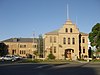 | December 15, 1978 (#78002694) | 54 N. Main St. 40°55′05″N 111°23′53″W / 40.918056°N 111.398056°W / 40.918056; -111.398056 (Summit County Courthouse) | Coalville | |
| 94 | Ephraim D. and William D. Sutton House | 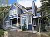 | July 12, 1984 (#84002362) | 713 Norfolk Ave. 40°38′47″N 111°29′57″W / 40.646389°N 111.499167°W / 40.646389; -111.499167 (Ephraim D. and William D. Sutton House) | Park City | |
| 95 | Milton and Minerva Thomas House |  | July 12, 1984 (#84002363) | 445 Park Ave. 40°38′37″N 111°29′45″W / 40.643611°N 111.495833°W / 40.643611; -111.495833 (Milton and Minerva Thomas House) | Park City | |
| 96 | William Tretheway House |  | July 12, 1984 (#84002364) | 335 Woodside Ave. 40°38′33″N 111°29′46″W / 40.6425°N 111.496111°W / 40.6425; -111.496111 (William Tretheway House) | Park City | |
| 97 | Union Pacific Park City Branch Railroad Grade |  | April 25, 1996 (#96000413) | Railroad grade parallel to I-80 from Echo to Park City 40°47′21″N 111°26′28″W / 40.789167°N 111.441111°W / 40.789167; -111.441111 (Union Pacific Park City Branch Railroad Grade) | Echo | |
| 98 | Matthew Urie House |  | July 12, 1984 (#84002366) | 157 Park Ave. 40°38′26″N 111°29′40″W / 40.640556°N 111.494444°W / 40.640556; -111.494444 (Matthew Urie House) | Park City | |
| 99 | Samuel D. Walker House | 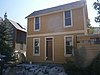 | July 12, 1984 (#84002368) | 1119 Park Ave. 40°39′01″N 111°30′04″W / 40.650278°N 111.501111°W / 40.650278; -111.501111 (Samuel D. Walker House) | Park City | |
| 100 | Washington School |  | December 8, 1978 (#78002699) | 541 Park Ave. 40°38′40″N 111°29′49″W / 40.644444°N 111.496944°W / 40.644444; -111.496944 (Washington School) | Park City | |
| 101 | Irinda Watson House |  | July 12, 1984 (#84002370) | 610 Park Ave. 40°38′45″N 111°29′48″W / 40.645833°N 111.496667°W / 40.645833; -111.496667 (Irinda Watson House) | Park City | |
| 102 | Patrick B. Watson House |  | May 16, 2002 (#02000504) | 962 Norfolk Ave. 40°38′55″N 111°30′02″W / 40.648611°N 111.500556°W / 40.648611; -111.500556 (Patrick B. Watson House) | Park City | |
| 103 | John C. Weeter House |  | January 21, 2004 (#84004002) | 843 Norfolk Ave. 40°38′51″N 111°30′00″W / 40.6475°N 111.5°W / 40.6475; -111.5 (John C. Weeter House) | Park City | |
| 104 | Welch-Sherman House |  | July 12, 1984 (#84002372) | 59 Prospect Ave. 40°38′19″N 111°29′34″W / 40.638611°N 111.492778°W / 40.638611; -111.492778 (Welch-Sherman House) | Park City | |
| 105 | Hannah Wells House |  | July 12, 1984 (#84002375) | 1103 Woodside Ave. 40°39′00″N 111°30′05″W / 40.65°N 111.501389°W / 40.65; -111.501389 (Hannah Wells House) | Park City | |
| 106 | Charles C. Whitehead House |  | October 22, 1984 (#84000160) | 937 Park Ave. 40°38′54″N 111°29′58″W / 40.648333°N 111.499444°W / 40.648333; -111.499444 (Charles C. Whitehead House) | Park City | |
| 107 | Walter and Ann Wilcocks House | 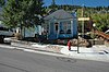 | July 12, 1984 (#84002378) | 363 Park Ave. 40°38′34″N 111°29′44″W / 40.642778°N 111.495556°W / 40.642778; -111.495556 (Walter and Ann Wilcocks House) | Park City | |
| 108 | Wilkinson-Hawkinson House | Upload image | July 12, 1984 (#84002418) | 39 Sampson Ave. 40°38′24″N 111°29′43″W / 40.64°N 111.495278°W / 40.64; -111.495278 (Wilkinson-Hawkinson House) | Park City | |
| 109 | Nathaniel J. Williams House | 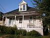 | July 12, 1984 (#84002419) | 945 Norfolk Ave. 40°38′53″N 111°30′02″W / 40.648056°N 111.500556°W / 40.648056; -111.500556 (Nathaniel J. Williams House) | Park City | |
| 110 | Reese Williams House |  | July 12, 1984 (#84002420) | 421 Park Ave. 40°38′36″N 111°29′45″W / 40.643333°N 111.495833°W / 40.643333; -111.495833 (Reese Williams House) | Park City | |
| 111 | Joseph S. Willis House |  | July 12, 1984 (#84002421) | 1062 Park Ave. 40°39′N 111°30′W / 40.65°N 111.5°W / 40.65; -111.5 (Joseph S. Willis House) | Park City | |
| 112 | Wilson-Shields House |  | July 12, 1984 (#84002422) | 139 Park Ave. 40°38′26″N 111°29′39″W / 40.640556°N 111.494167°W / 40.640556; -111.494167 (Wilson-Shields House) | Park City |
Former listings
| [4] | Name on the Register | Image | Date listed | Date removed | Location | City or town | Description |
|---|---|---|---|---|---|---|---|
| 1 | Thomas Cunningham House | Upload image | July 12, 1984 (#84002250) | March 26, 2018 | 139 Main St. 40°38′27″N 111°29′37″W / 40.640833°N 111.493611°W / 40.640833; -111.493611 (Thomas Cunningham House) | Park City | |
| 2 | Silver King Ore Loading Station | Upload image | October 4, 1978 (#78002698) | May 15, 2001 | Park Avenue | Park City | Destroyed by arsonist on July 23, 1981.[9] |
| 3 | Summit Stake Tabernacle |  | February 22, 1971 (#71001078) | April 9, 1971 | 1st North and Main Sts. | Coalville | Also known as the Coalville Tabernacle, designed and built by Thomas L. Allen, whose house is NRHP-listed. Tabernacle was demolished in 1971 shortly after its NRHP listing.[10] |
See also
References
- ^ The latitude and longitude information provided in this table was derived originally from the National Register Information System, which has been found to be fairly accurate for about 99% of listings. Some locations in this table may have been corrected to current GPS standards.
- ^ a b Roger Roper; Deborah Randall (April 1984). National Register of Historic Places Inventory-Nomination: Mining Boom Era Houses Thematic Resources (Report). Retrieved October 25, 2019.
- ^ National Park Service, United States Department of the Interior, "National Register of Historic Places: Weekly List Actions", retrieved July 12, 2024.
- ^ a b Numbers represent an alphabetical ordering by significant words. Various colorings, defined here, differentiate National Historic Landmarks and historic districts from other NRHP buildings, structures, sites or objects.
- ^ "National Register Information System". National Register of Historic Places. National Park Service. April 24, 2008.
- ^ The eight-digit number below each date is the number assigned to each location in the National Register Information System database, which can be viewed by clicking the number.
- ^ Federal and state laws and practices restrict general public access to information regarding the specific location of this resource. In some cases, this is to protect archeological sites from vandalism, while in other cases it is restricted at the request of the owner. See: Knoerl, John; Miller, Diane; Shrimpton, Rebecca H. (1990), Guidelines for Restricting Information about Historic and Prehistoric Resources, National Register Bulletin, National Park Service, U.S. Department of the Interior, OCLC 20706997.
- ^ a b Some listings on the NRHP are highly sensitive sites and may be subject to looting or vandalism. The NRHP lists this site as "Address Restricted."
- ^ "Silver King Coalition Mines Building Lost To Fire". The Park Record. July 23, 1981. p. Special Section, pp1-7. Retrieved August 31, 2022 – via Newspapers.com.
- ^ "Demolition Work Begins On Coalville Tabernacle". The Salt Lake Tribune. March 4, 1971. p. B1. Retrieved August 31, 2022 – via Newspapers.com.
External links
Map all coordinates using OpenStreetMap
Download coordinates as:
- KML
- GPX (all coordinates)
- GPX (primary coordinates)
- GPX (secondary coordinates)
![]() Media related to National Register of Historic Places in Summit County, Utah at Wikimedia Commons
Media related to National Register of Historic Places in Summit County, Utah at Wikimedia Commons
- v
- t
- e

| |
|---|---|
| Topics | |
| Lists by state |
|
| Lists by insular areas | |
| Lists by associated state | |
| Other areas | |
| Related | |
| |


Municipalities and communities of Summit County, Utah, United States | ||
|---|---|---|
County seat: Coalville | ||
| Cities |  | |
| Towns | ||
| CDPs | ||
| Unincorporated communities | ||
| Ghost towns | ||
| Footnotes | ‡This populated place also has portions in an adjacent county or counties | |
| ||


