National Register of Historic Places listings in Clarke County, Georgia
This is a list of properties and districts in Clarke County, Georgia that are listed on the National Register of Historic Places (NRHP).
Map all coordinates using OpenStreetMap
Download coordinates as:
- KML
- GPX (all coordinates)
- GPX (primary coordinates)
- GPX (secondary coordinates)
This National Park Service list is complete through NPS recent listings posted June 21, 2024.[1]
- v
- t
- e
Properties on the National Register of Historic Places in Georgia by county
- Appling
- Atkinson
- Bacon
- Baker
- Baldwin
- Banks
- Barrow
- Bartow
- Ben Hill
- Berrien
- Bibb
- Bleckley
- Brantley
- Brooks
- Bryan
- Bulloch
- Burke
- Butts
- Calhoun
- Camden
- Candler
- Carroll
- Catoosa
- Charlton
- Chatham
- Chattahoochee
- Chattooga
- Cherokee
- Clarke
- Clay
- Clayton
- Clinch
- Cobb
- Coffee
- Colquitt
- Columbia
- Cook
- Coweta
- Crawford
- Crisp
- Dade
- Dawson
- Decatur
- DeKalb
- Dodge
- Dooly
- Dougherty
- Douglas
- Early
- Echols
- Effingham
- Elbert
- Emanuel
- Evans
- Fannin
- Fayette
- Floyd
- Forsyth
- Franklin
- Fulton
- Gilmer
- Glascock
- Glynn
- Gordon
- Grady
- Greene
- Gwinnett
- Habersham
- Hall
- Hancock
- Haralson
- Harris
- Hart
- Heard
- Henry
- Houston
- Irwin
- Jackson
- Jasper
- Jeff Davis
- Jefferson
- Jenkins
- Johnson
- Jones
- Lamar
- Lanier
- Laurens
- Lee
- Liberty
- Lincoln
- Long
- Lowndes
- Lumpkin
- Macon
- Madison
- Marion
- McDuffie
- McIntosh
- Meriwether
- Miller
- Mitchell
- Monroe
- Montgomery
- Morgan
- Murray
- Muscogee
- Newton
- Oconee
- Oglethorpe
- Paulding
- Peach
- Pickens
- Pierce
- Pike
- Polk
- Pulaski
- Putnam
- Quitman
- Rabun
- Randolph
- Richmond
- Rockdale
- Schley
- Screven
- Seminole
- Spalding
- Stephens
- Stewart
- Sumter
- Talbot
- Taliaferro
- Tattnall
- Taylor
- Telfair
- Terrell
- Thomas
- Tift
- Toombs
- Towns
- Treutlen
- Troup
- Turner
- Twiggs
- Union
- Upson
- Walker
- Walton
- Ware
- Warren
- Washington
- Wayne
- Webster
- Wheeler
- White
- Whitfield
- Wilcox
- Wilkes
- Wilkinson
- Worth

Current listings
| [2] | Name on the Register | Image | Date listed[3] | Location | City or town | Description |
|---|---|---|---|---|---|---|
| 1 | Athens Factory |  | July 31, 1980 (#80000989) | Baldwin and Williams Sts. 33°57′10″N 83°22′10″W / 33.952778°N 83.369444°W / 33.952778; -83.369444 (Athens Factory) | Athens | |
| 2 | Athens Manufacturing Company |  | December 31, 2002 (#02001634) | 585 While Circle 33°54′20″N 83°21′28″W / 33.905556°N 83.357778°W / 33.905556; -83.357778 (Athens Manufacturing Company) | Athens | |
| 3 | Athens Warehouse Historic District |  | October 20, 1988 (#88002021) | Roughly bounded by Hancock and Thomas Sts., and the RR tracks 33°57′32″N 83°22′17″W / 33.958889°N 83.371389°W / 33.958889; -83.371389 (Athens Warehouse Historic District) | Athens | |
| 4 | Bishop House |  | March 16, 1972 (#72000375) | Jackson St., University of Georgia campus 33°57′21″N 83°22′23″W / 33.955833°N 83.373056°W / 33.955833; -83.373056 (Bishop House) | Athens | |
| 5 | Bloomfield Street Historic District |  | April 18, 1985 (#85000850) | Roughly bounded by Bloomfield and Peabody Sts., U of G campus, Rutherford St and Milledge Ave. 33°56′44″N 83°23′06″W / 33.945556°N 83.385°W / 33.945556; -83.385 (Bloomfield Street Historic District) | Athens | |
| 6 | Boulevard Historic District |  | April 18, 1985 (#85000851) | Roughly bounded by the Seaboard Coastline RR tracks, Pulaski St., Prince Ave., and Hiawassee St. 33°57′54″N 83°23′23″W / 33.965°N 83.389722°W / 33.965; -83.389722 (Boulevard Historic District) | Athens | |
| 7 | Brightwell Shotgun Row | 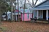 | June 14, 2001 (#01000642) | 366-376 Barber St. 33°57′59″N 83°23′08″W / 33.966389°N 83.385556°W / 33.966389; -83.385556 (Brightwell Shotgun Row) | Athens | |
| 8 | Buena Vista Heights Historic District | 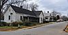 | August 27, 1999 (#99001029) | Roughly bounded by Park Ave., Prince Ave., Pound St., and Nantahala Extension 33°57′58″N 83°24′06″W / 33.966111°N 83.401667°W / 33.966111; -83.401667 (Buena Vista Heights Historic District) | Athens | |
| 9 | Camak House | 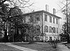 | July 7, 1975 (#75000576) | 279 Meigs St. 33°57′34″N 83°23′00″W / 33.95937°N 83.383324°W / 33.95937; -83.383324 (Camak House) | Athens | |
| 10 | Carnegie Library Building | 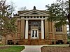 | November 11, 1975 (#75000577) | 1401 Prince Ave. 33°57′50″N 83°24′16″W / 33.963889°N 83.404444°W / 33.963889; -83.404444 (Carnegie Library Building) | Athens | |
| 11 | Albon Chase House | 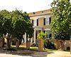 | August 19, 1974 (#74002255) | 185 N. Hull St. 33°57′27″N 83°22′45″W / 33.9575°N 83.379167°W / 33.9575; -83.379167 (Albon Chase House) | Athens | |
| 12 | Chestnut Grove School | 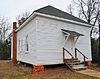 | June 28, 1984 (#84003873) | 610 Epps Bridge Rd. 33°55′59″N 83°26′18″W / 33.933056°N 83.438333°W / 33.933056; -83.438333 (Chestnut Grove School) | Athens | |
| 13 | Chi Omega House |  | July 11, 2019 (#100003491) | 324 S. Milledge Ave. 33°57′09″N 83°23′16″W / 33.95237°N 83.38791°W / 33.95237; -83.38791 (Chi Omega House) | Athens | |
| 14 | Church-Waddel-Brumby House |  | February 20, 1975 (#75000578) | 280 E. Dougherty St. 33°57′43″N 83°22′33″W / 33.961944°N 83.375833°W / 33.961944; -83.375833 (Church-Waddel-Brumby House) | Athens | |
| 15 | Clarke County Jail |  | May 29, 1980 (#80000990) | Courthouse Sq. 33°57′34″N 83°23′06″W / 33.959444°N 83.385°W / 33.959444; -83.385 (Clarke County Jail) | Athens | |
| 16 | T. R. R. Cobb House |  | June 30, 1975 (#75000579) | 194 Prince Ave. 33°57′40″N 83°22′54″W / 33.961111°N 83.381667°W / 33.961111; -83.381667 (T. R. R. Cobb House) | Athens | De-listed in 1985, but re-listed on July 23, 2013[4] |
| 17 | Cobb-Treanor House |  | May 8, 1979 (#79000705) | 1234 S. Lumpkin St. 33°56′42″N 83°22′46″W / 33.945°N 83.379444°W / 33.945; -83.379444 (Cobb-Treanor House) | Athens | |
| 18 | Cobbham Historic District |  | August 24, 1978 (#78000973) | Roughly bounded by Prince Ave., Hill, Reese, and Pope Sts. 33°57′32″N 83°23′31″W / 33.958889°N 83.391944°W / 33.958889; -83.391944 (Cobbham Historic District) | Athens | |
| 19 | Coca-Cola Bottling Plant-Athens |  | February 1, 2006 (#05001594) | 297 Prince Ave. 33°57′35″N 83°23′00″W / 33.959722°N 83.383333°W / 33.959722; -83.383333 (Coca-Cola Bottling Plant-Athens) | Athens | |
| 20 | Ross Crane House |  | June 18, 1979 (#79000706) | 247 Pulaski St. 33°57′30″N 83°22′51″W / 33.958333°N 83.380833°W / 33.958333; -83.380833 (Ross Crane House) | Athens | |
| 21 | Dearing Street Historic District |  | September 5, 1975 (#75000580) | Roughly bounded by Broad and Baxter Sts., Milledge Ave., and includes both sides of Finley St. and Henderson Ave. 33°57′11″N 83°23′07″W / 33.953056°N 83.385278°W / 33.953056; -83.385278 (Dearing Street Historic District) | Athens | includes the Tree That Owns Itself |
| 22 | Albin P. Dearing House | 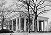 | May 8, 1979 (#79000707) | 338 S. Milledge Ave. 33°57′07″N 83°23′16″W / 33.95196°N 83.38785°W / 33.95196; -83.38785 (Albin P. Dearing House) | Athens | Now Kappa Alpha Theata house |
| 23 | Downtown Athens Historic District |  | August 10, 1978 (#78000974) | Roughly bounded by Hancock Ave., Foundry, Mitchell 33°57′30″N 83°22′25″W / 33.958333°N 83.373611°W / 33.958333; -83.373611 (Downtown Athens Historic District) | Athens | There was a boundary increase on May 31, 1984 (refnum 84000965), and a boundary increase and decrease on August 18, 2006 (refnum 06000737) |
| 24 | First African Methodist Episcopal Church |  | March 10, 1980 (#80000991) | 521 N. Hull St. 33°57′39″N 83°22′46″W / 33.960833°N 83.379444°W / 33.960833; -83.379444 (First African Methodist Episcopal Church) | Athens | |
| 25 | Franklin House | 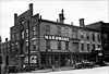 | December 11, 1974 (#74000667) | 464-480 E. Broad St. 33°57′28″N 83°22′35″W / 33.957778°N 83.376389°W / 33.957778; -83.376389 (Franklin House) | Athens | |
| 26 | Garden Club of Georgia Museum-Headquarters House, Founder's Memorial Garden | 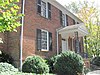 | April 26, 1972 (#72000376) | Lumpkin St., University of Georgia campus 33°57′15″N 83°22′33″W / 33.954167°N 83.375833°W / 33.954167; -83.375833 (Garden Club of Georgia Museum-Headquarters House, Founder's Memorial Garden) | Athens | |
| 27 | Gospel Pilgrim Cemetery | 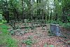 | April 19, 2006 (#06000285) | 530 Fourth St. 33°58′09″N 83°21′41″W / 33.969167°N 83.361389°W / 33.969167; -83.361389 (Gospel Pilgrim Cemetery) | Athens | |
| 28 | Henry W. Grady House |  | May 11, 1976 (#76000613) | 634 Prince Ave. 33°57′42″N 83°23′18″W / 33.96167°N 83.38827°W / 33.96167; -83.38827 (Henry W. Grady House) | Athens | National Historic Landmark |
| 29 | Dr. James S. Hamilton House |  | April 24, 1979 (#79000708) | 150 S. Milledge Ave. 33°57′16″N 83°23′19″W / 33.954444°N 83.388611°W / 33.954444; -83.388611 (Dr. James S. Hamilton House) | Athens | |
| 30 | Jackson Street Cemetery | 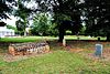 | October 2, 2009 (#09000779) | S. Jackson St., University of Georgia campus 33°57′21″N 83°22′25″W / 33.955833°N 83.373611°W / 33.955833; -83.373611 (Jackson Street Cemetery) | Athens | |
| 31 | Lucy Cobb Institute Campus |  | March 16, 1972 (#72000377) | 200 N. Milledge Ave., University of Georgia campus 33°57′22″N 83°23′23″W / 33.956111°N 83.389722°W / 33.956111; -83.389722 (Lucy Cobb Institute Campus) | Athens | |
| 32 | Gov. Wilson Lumpkin House |  | March 16, 1972 (#72000378) | Cedar St., University of Georgia campus 33°56′51″N 83°22′26″W / 33.9475°N 83.373889°W / 33.9475; -83.373889 (Gov. Wilson Lumpkin House) | Athens | |
| 33 | Joseph Henry Lumpkin House | 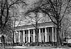 | June 27, 1975 (#75000581) | 248 Prince Ave. 33°57′38″N 83°22′57″W / 33.960556°N 83.3825°W / 33.960556; -83.3825 (Joseph Henry Lumpkin House) | Athens | |
| 34 | Milledge Avenue Historic District |  | April 18, 1985 (#85000852) | Milledge Ave. from Broad St. to Five Points 33°56′52″N 83°23′16″W / 33.947778°N 83.387778°W / 33.947778; -83.387778 (Milledge Avenue Historic District) | Athens | Boundary increase (listed September 24, 2009): 295 W. Rutherford St. |
| 35 | Milledge Circle Historic District |  | April 18, 1985 (#85000859) | Milledge Park, Lumpkin St., Milledge Circle and Milledge Ave. 33°56′15″N 83°23′22″W / 33.9375°N 83.389444°W / 33.9375; -83.389444 (Milledge Circle Historic District) | Athens | |
| 36 | Morton Building |  | October 22, 1979 (#79000709) | 199 W. Washington St. 33°57′31″N 83°22′43″W / 33.958611°N 83.378611°W / 33.958611; -83.378611 (Morton Building) | Athens | |
| 37 | Newton House |  | July 11, 2002 (#02000759) | 892 Prince Ave. 33°57′43″N 83°23′34″W / 33.961944°N 83.392778°W / 33.961944; -83.392778 (Newton House) | Athens | |
| 38 | Oconee Hill Cemetery | 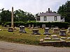 | May 22, 2013 (#13000291) | 297 Cemetery St. 33°57′04″N 83°22′06″W / 33.951067°N 83.368335°W / 33.951067; -83.368335 (Oconee Hill Cemetery) | Athens | |
| 39 | Oconee Street School | Upload image | December 31, 2018 (#100003284) | 594 Oconee St. 33°57′09″N 83°21′59″W / 33.952453°N 83.366365°W / 33.952453; -83.366365 (Oconee Street School) | Athens | |
| 40 | Oglethorpe Avenue Historic District |  | November 5, 1987 (#87001360) | Oglethorpe Ave. 33°57′58″N 83°24′15″W / 33.966111°N 83.404167°W / 33.966111; -83.404167 (Oglethorpe Avenue Historic District) | Athens | |
| 41 | Old North Campus, University of Georgia | 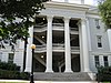 | March 16, 1972 (#72000379) | Bounded by Broad, Lumpkin, and Jackson Sts. 33°58′01″N 83°22′30″W / 33.966944°N 83.375°W / 33.966944; -83.375 (Old North Campus, University of Georgia) | Athens | |
| 42 | Hubert Bond Owens House |  | May 14, 2008 (#08000442) | 215 W. Rutherford St. 33°56′34″N 83°23′10″W / 33.9427°N 83.386°W / 33.9427; -83.386 (Hubert Bond Owens House) | Athens | |
| 43 | Calvin W. Parr House |  | September 9, 1982 (#82002394) | 227 Bloomfield St. 33°56′53″N 83°23′09″W / 33.948056°N 83.385833°W / 33.948056; -83.385833 (Calvin W. Parr House) | Athens | |
| 44 | Parrott Insurance Building | 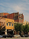 | October 7, 1977 (#77000416) | 283 E. Broad St. 33°57′28″N 83°22′30″W / 33.957778°N 83.375°W / 33.957778; -83.375 (Parrott Insurance Building) | Athens | |
| 45 | President's House | 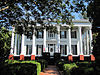 | March 16, 1972 (#72000380) | 570 Prince Ave. 33°57′41″N 83°23′11″W / 33.961389°N 83.386389°W / 33.961389; -83.386389 (President's House) | Athens | |
| 46 | Reese Street Historic District | 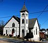 | November 10, 1987 (#87001990) | Roughly bounded by Meigs, Finley, Broad, & Harris Sts. 33°57′26″N 83°23′06″W / 33.957222°N 83.385°W / 33.957222; -83.385 (Reese Street Historic District) | Athens | Includes the Hill First Baptist Church. |
| 47 | Rocksprings Shotgun Row Historic District | 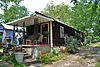 | August 23, 1996 (#96000875) | 433-447 Rocksprings St. 33°56′50″N 83°23′29″W / 33.947222°N 83.391389°W / 33.947222; -83.391389 (Rocksprings Shotgun Row Historic District) | Athens | |
| 48 | James A. Sledge House | 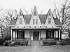 | February 12, 1974 (#74000668) | 749 Cobb St. 33°57′37″N 83°23′49″W / 33.960278°N 83.396944°W / 33.960278; -83.396944 (James A. Sledge House) | Athens | |
| 49 | R. P. Sorrells House | 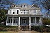 | January 22, 1992 (#91002003) | 220 Prince Ave. 33°57′38″N 83°22′56″W / 33.960556°N 83.382222°W / 33.960556; -83.382222 (R. P. Sorrells House) | Athens | |
| 50 | Thomas-Carithers House | 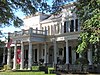 | May 8, 1979 (#79000710) | 530 S. Milledge Ave. 33°56′56″N 83°23′16″W / 33.948889°N 83.387778°W / 33.948889; -83.387778 (Thomas-Carithers House) | Athens | |
| 51 | Upson House | 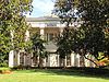 | November 15, 1973 (#73000616) | 1022 Prince Ave. 33°57′14″N 83°23′40″W / 33.953889°N 83.394444°W / 33.953889; -83.394444 (Upson House) | Athens | |
| 52 | United States Post Office and Courthouse |  | September 10, 2014 (#14000554) | 115 E. Hancock St. 33°57′36″N 83°22′38″W / 33.9599°N 83.3773°W / 33.9599; -83.3773 (United States Post Office and Courthouse) | Athens | |
| 53 | Ware-Lyndon House |  | March 15, 1976 (#76000614) | 293 Hoyt St. 33°57′50″N 83°22′35″W / 33.963889°N 83.376389°W / 33.963889; -83.376389 (Ware-Lyndon House) | Athens | |
| 54 | West Cloverhurst Avenue Historic District |  | September 27, 2007 (#07001000) | W. Cloverhurst Ave. vet. Springdale St. and S. Milledge Ave. 33°56′39″N 83°23′30″W / 33.944261°N 83.391631°W / 33.944261; -83.391631 (West Cloverhurst Avenue Historic District) | Athens | |
| 55 | West Hancock Avenue Historic District | 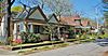 | March 30, 1988 (#88000227) | Roughly bounded by Hill, Franklin, Broad Sts. and the Plaza 33°57′20″N 83°23′38″W / 33.955556°N 83.393889°W / 33.955556; -83.393889 (West Hancock Avenue Historic District) | Athens | |
| 56 | White Hall | 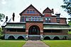 | June 18, 1979 (#79000711) | Whitehall and Simonton Bridge Rds. 33°53′48″N 83°21′50″W / 33.896667°N 83.363889°W / 33.896667; -83.363889 (White Hall) | Whitehall | |
| 57 | Wilkins House |  | May 19, 1970 (#70000202) | 387 S. Milledge Ave. 33°57′04″N 83°23′12″W / 33.951111°N 83.386667°W / 33.951111; -83.386667 (Wilkins House) | Athens | |
| 58 | Winterville Historic District |  | October 11, 2001 (#01000742) | Roughly center on Main St. and on the abandoned Georgia RR line within the city limits of Winterville 33°58′03″N 83°16′40″W / 33.9675°N 83.277778°W / 33.9675; -83.277778 (Winterville Historic District) | Winterville | |
| 59 | Woodlawn Historic District |  | October 23, 1987 (#87001390) | Woodlawn Ave. 33°56′31″N 83°22′53″W / 33.941944°N 83.381389°W / 33.941944; -83.381389 (Woodlawn Historic District) | Athens | |
| 60 | Young Women's Christian Association Complex |  | May 12, 1987 (#87000696) | 345-347 W. Hancock St. 33°57′31″N 83°22′51″W / 33.958611°N 83.380833°W / 33.958611; -83.380833 (Young Women's Christian Association Complex) | Athens |
References
- ^ National Park Service, United States Department of the Interior, "National Register of Historic Places: Weekly List Actions", retrieved June 21, 2024.
- ^ Numbers represent an alphabetical ordering by significant words. Various colorings, defined here, differentiate National Historic Landmarks and historic districts from other NRHP buildings, structures, sites or objects.
- ^ The eight-digit number below each date is the number assigned to each location in the National Register Information System database, which can be viewed by clicking the number.
- ^ "Cobb, T. R. R., House". National Register of Historic Places Program. National Park Service. Retrieved August 26, 2013.
Wikimedia Commons has media related to National Register of Historic Places in Clarke County, Georgia.
| |
|---|---|
| Topics | |
| Lists by state |
|
| Lists by insular areas | |
| Lists by associated state | |
| Other areas | |
| Related | |
| |


