Moulsoe
Human settlement in England
- Moulsoe
- Buckinghamshire
- South East
- Milton Keynes North
- List of places
- UK
- England
- Buckinghamshire
52°04′07″N 0°40′24″W / 52.0687°N 0.6733°W / 52.0687; -0.6733

Moulsoe is a village and civil parish in the unitary authority area of the City of Milton Keynes, Buckinghamshire, England.[2] It is on the border with Bedfordshire, and just east of the M1, situated about 2.5 miles (4.0 km) ESE of Newport Pagnell, and about 5 miles (8.0 km) NNE of Central Milton Keynes. The main road through the village is the Newport Road coming from the west, changing to the Cranfield Road going east at a bend by the church.
The village name is an Old English language word which means 'Mul's hill spur'. In the Domesday Book of 1086 the village was recorded as Moleshou.[3]
At the 2011 Census, the population of the parish was 318,[1] down slightly from 330 at the 2001 census.[4] As of 2019[update], the parish is mainly rural but a large area just west of the village has been identified for future expansion of Milton Keynes.[5]
There are several old thatched dwellings. Other buildings are of brick apart from some concrete council houses to the west and the church which is of stone, and dates from the 12th century.[6] There is an inn, the Carrington Arms, and a village hall, the Millennium Hall.[7]
Caldecote
Caldecote is a tiny hamlet in the parish, notable because of it being mentioned in Domesday.[8]
Gallery
-
 Yew Tree Cottage, Newport Road
 -
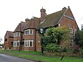 The Carrington Arms, Cranfield Road
 -
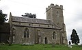 St Mary's church, view from Newport Road


References
- ^ a b UK Census (2011). "Local Area Report – Moulsoe (E04001264)". Nomis. Office for National Statistics. Retrieved 19 November 2019.
- ^ "Contact your Parish, Town or Community Council". Milton Keynes Council. Retrieved 10 October 2020.
- ^ moulsoe.net/history.htm
- ^ http://www.mkweb.co.uk/statistics/documents/Population%5FBulletin%5F2005%2D6%2Epdf Archived 11 September 2006 at the Wayback Machine, page 22
- ^ Jessica MacKinnon (11 August 2019). "Milton Keynes East Development Framework". communityactionmk.org. Retrieved 19 November 2019.
- ^ Parish of Newport Pagnell Archived 2012-08-02 at the Wayback Machine St Mary's
- ^ www.milton-keynes.gov.uk Archived 2012-12-23 at archive.today Moulsoe Millennium Hall
- ^ "Buckinghamshire A-E". The Domesday Book Online. Retrieved 23 November 2022.
External links
![]() Media related to Moulsoe at Wikimedia Commons
Media related to Moulsoe at Wikimedia Commons
- v
- t
- e
- Abbey Hill
- Astwood and Hardmead
- Bletchley and Fenny Stratford
- Bow Brickhill
- Bradwell
- Broughton
- Calverton
- Campbell Park
- Castlethorpe
- Central Milton Keynes
- Chicheley
- Clifton Reynes
- Cold Brayfield
- Emberton
- Fairfields
- Gayhurst
- Great Linford
- Hanslope
- Haversham-cum-Little Linford
- Kents Hill, Monkston and Brinklow
- Lathbury
- Lavendon
- Little Brickhill
- Loughton and Great Holm
- Milton Keynes
- Moulsoe
- New Bradwell
- Newport Pagnell
- Newton Blossomville
- North Crawley
- Old Woughton
- Olney
- Ravenstone
- Shenley Brook End
- Shenley Church End
- Sherington
- Simpson and Ashland
- Stantonbury
- Stoke Goldington
- Stony Stratford
- Tyringham and Filgrave
- Walton
- Warrington
- Wavendon
- West Bletchley
- Weston Underwood
- Whitehouse
- Woburn Sands
- Wolverton and Greenleys
- Woughton
 | This Buckinghamshire location article is a stub. You can help Wikipedia by expanding it. |
- v
- t
- e


