Meteorological history of Cyclone Freddy
Part of the 2022–23 Australian region and South-West Indian Ocean cyclone seasons | |
History
Response Other wikis
|
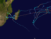
Cyclone Freddy was the longest-lived tropical cyclone ever observed worldwide. It also broke numerous meteorological records during the months of February and March 2023. Originating from a Madden–Julian oscillation in conjunction with an equatorial Rossby wave, it developed into a tropical low on 5 February as it was situated to the south of the Indonesian archipelago. The following day, the tropical low intensified into a Category 1 tropical cyclone on the Australian scale—the fourth tropical cyclones of the 2023–24 Australian region cyclone season. Located just within Tropical Cyclone Warning Centre Melbourne's area of responsibility, the storm was named Freddy by the Bureau of Meteorology (BoM). Freddy quickly intensified and became a Category 4 severe tropical cyclone before it moved into the area of responsibility of Météo-France La Réunion. As the second very intense tropical cyclone of the 2023–24 South-West Indian Ocean cyclone season. Freddy peaked with winds of 230 km/h (145 mph) and a central barometric pressure of 927 hPa (27.37 inHg).
After briefly weakening from its peak intensity, Cyclone Freddy made landfall below Category 3-equivalent intensity near Mananjary, Madagascar, on 21 February. It further weakened as it moved overland but regained strength upon reaching the Mozambique Channel. The cyclone then made its second landfall near Vilankulos, Mozambique, as a moderate tropical storm status on 24 February. Upon re-emerging into the channel, it began to regain tropical characteristics and subsequently intensified into a tropical cyclone status just before making a final landfall near Quelimane, Mozambique, on 11 March. Thereafter, it gradually weakened and dissipated late on 14 March.
Formation and intensification

An active phrase of the Madden–Julian oscillation in conjunction with an equatorial Rossby wave led to the formation of a tropical low—identified as 13U—on 5 February 2023, when it was situated to the south of the Indonesian archipelago.[1] Soon after, the United States Joint Typhoon Warning Center (JTWC)[nb 1] issued a tropical cyclone formation alert, noting that the disturbance was located in a favourable environment with low wind shear and sea surface temperatures of 29–30 °C (84–86 °F).[3] Early on 6 February, the JTWC began issuing warnings on the system, classifying it as Tropical Cyclone 11S, approximately 401 mi (645 km) north-northwest of Broome, Western Australia.[4] Deep convection increased and the system achieved Category 1 tropical cyclone on the Australian scale by 12:00 UTC; the Australian Bureau of Meteorology (BoM)[nb 2] assigned it the name Freddy accordingly.[1][6] As the storm moved away from the Australian basin, it began to rapidly organize and developed an eye feature on microwave imagery. As a result, it was classified as a Category 2-equivalent intensity by the JTWC.[7] As the day progressed, the system became increasingly susceptible to wind shear, causing Freddy to weaken back into a minimal tropical storm.[8][9]
The cyclone quickly restrengthened with the storm becoming a Category 3 severe tropical cyclone—attaining an initial peak intensity with winds of 150 km/h (90 mph)—and at 18:00 UTC on 11 February, Freddy reached its second peak intensity as a high-end Category 4 severe tropical cyclone in the Australian basin, with winds of 175 km/h (110 mph) and a central barometric pressure barometric pressure of 951 hPa (28.08 inHg).[1] The cyclone's eyewall displayed cloud tops warming to below −130 °F (−90 °C) while passing over sea surface temperatures of 29 °C (84 °F).[10] The cyclone's structure continued to gradually weaken before moving over the South-West Indian Ocean.[1] At around 12:00 UTC on 14 February, the BoM passed the responsibility of tracking the system over to the Météo-France office on La Réunion (MFR).[nb 3] Thus, the system was initially classified as a tropical cyclone status before being later upgraded to intense tropical cyclone status.[12][13]
Peak intensity

Cyclone Freddy acquired annular characteristics, bearing a symmetrical appearance and a well-defined 10 mi (16 km) wide pinhole eye, which was largely surrounded by central dense overcast.[14] lt underwent a steady weakening trend due to cooling sea surface temperatures and cloud top temperatures.[15] On 15 February at 03:00 UTC, the JTWC reported that the cyclone re-strengthened and underwent another period of rapid intensification, reaching Category 4-equivalent intensity;[16] however, post-season analysis determined that it had attained winds of 270 km/h (165 mph) and a central barometric pressure of 918 hPa (27.11 inHg)—making Freddy equivalent to a Category 5 intensity.[17][18] After maintaining Category 5 intensity for about 12 hours, Freddy weakened slightly before restrengthening back to Category 5 intensity on 19 February.[19] It then strengthened further to its peak intensity as a very intense tropical cyclone—the highest rating on the MFR's classification scale—with 10-minute sustained winds of 230 km/h (145 mph) and the lowest atmospheric pressure of 927 hPa (27.37 inHg).[20]
After reaching its peak intensity, Freddy eye's pattern rapidly eroded as the cloud tops warmed significantly, causing Freddy to weaken to an intense tropical cyclone status by the afternoon of 20 February.[21] The system subsequently passed north of the Mascarene Islands as it turned west-southwestward.[22] After passing the islands, Freddy made landfall below Category 3-equivalent intensity near Mananjary, Madagascar, with winds about 175 km/h (110 mph) on 21 February.[23][24] That night, Freddy rapidly weakened upon encountered the mountainous terrain of the island nation and was downgraded to overland depression status.[25] Upon emerging over the Mozambique Channel by 23 February, the system had strengthened to attain moderate tropical storm—aided by warm waters and a favorable environmental conditions.[26] An automated weather station on Europa Island indicated that Freddy had wind gusts up to 235 km/h (146 mph) after passing north of the island.[27][28]
Later that same day, the cyclone intensified into a severe tropical storm, with convection wrapping around it and forming distinct banding features.[29][30] At around 12:00 UTC on 24 February, Freddy made landfall in Mozambique south of Vilankulos, with winds about 85 km/h (50 mph), just below severe tropical storm strength.[31] Freddy rapidly weakened as it moved westward and further inland, weakening to an overland depression status by 18:00 UTC that day.[32]
Demise

By 28 February, the MFR continued to monitor the disturbance and predicted that the remnant low would likely reemerge into the channel and redevelop into a tropical system.[33][34] Early on 1 March, Freddy emerged again into the channel—benefiting from favorable environmental conditions such as low vertical wind shear, good upper-level divergence, and sea surface temperatures of 28–29 °C (82–84 °F).[35][36] By 3 March, the system showed signs of intensification, causing the MFR to upgrade it to a tropical depression.[37][38] On 5 March at 18:00 UTC, Freddy strengthened into a severe tropical storm status as it accelerated eastward toward the coast of Madagascar.[39][40] The cyclone unexpectedly intensified—developing an ill-defined eye—which prompted the MFR to upgrade it to tropical cyclone status with sustained winds of 150 km/h (90 mph) by 12:00 UTC on 7 March.[41][42]
Around 03:00 UTC on 9 March, the cyclone rapidly weakened to slightly below minimal tropical storm strength due to increased wind shear and dry air intrusion.[43] By the start of 10 March, the storm's convective organization steadily improved, with developing banding features.[44] Forecasters at the JTWC described the system as "a B-reel horror movie that never ends.'"[45] Freddy rapidly re-strengthened and made landfall for the final time as a Category 2-equivalent intensity near Quelimane, Mozambique on 11 March, with winds of about 175 km/h (110 mph).[46] The cyclone featured a well-defined eye within its compact and symmetrical central dense overcast.[47][48] Once onshore, the cyclone quickly weakened, and its cloud pattern deteriorated.[49] Within two hours, its eye disappeared from satellite imagery.[50] The MFR estimated Freddy to have fallen below tropical cyclone status by 12:00 UTC on 12 March.[50] Freddy was tracked as a below-tropical cyclone until it was last noted on 14 March, marking its cessation.[51] And, late that same day, the storm's remnants continued to travel northwards, bringing rain to Malawi and several provinces in Mozambique.[52]
Records
Cyclone Freddy's 36-day existence made it the longest-lasting tropical cyclone recorded worldwide, surpassing Hurricane John's previous record in the 1994 season.[nb 4][53] Additionally, Freddy was the second-farthest traveling tropical cyclone globally, behind 1994's Hurricane John, and the furthest in the Indian Ocean, covering a distance of 12,785 km (7,945 mi), which is approximately 33% of the Earth's circumference.[53] Moreover, it achieved the highest accumulated cyclone energy of any tropical cyclone, reaching an ACE of 87.01, equivalent to an average Atlantic hurricane season, and surpassing the previous record set by Hurricane Ioke in 2006.[54][55] It later became the first tropical cyclone to undergo seven separate rounds of rapid intensification.[56] It exceeded the previous records held by Hurricane Norman in 2018, Hurricane Emily in 2005, and 1994's Hurricane John.[57] Further, it was one of only four systems to traverse the entirety of the southern Indian Ocean from east to west; the others were Cyclone Litanne in 1994 as well as Cyclone Leon–Eline and Hudah in 2000.[55]
Chris Velden of the World Meteorological Organization described the cyclone as "remarkable."[53] Sébastien Langlade of Météo-France La Réunion referred to the storm as "Freddy and Freddy 2.0," highlighting its track as "quite unusual.""[58]
See also
 Tropical cyclones portal

- Cyclones Katrina and Victor–Cindy (1998) – An extremely long-lived tropical cyclone in the South Pacific that eventually regenerated into another cyclone in the Indian Ocean
- Hurricanes Dora in 1999 and in 2023 – Both tracked across all three north Pacific basins
Notes
- ^ The Joint Typhoon Warning Center is a joint United States Navy – United States Air Force task force that issues tropical cyclone warnings for the Indian Ocean and other regions.[2]
- ^ The Tropical Cyclone Warning Centre in Melbourne, Australia, is a branch of the country's Bureau of Meteorology, which is the official Regional Specialized Meteorological Center for the Australian basin.[5]
- ^ Météo-France's meteorological office in Réunion (MFR) is the official Regional Specialized Meteorological Center for the South-West Indian Ocean, tracking all tropical cyclones south of the equator, from the east coast of Africa to 90° E.[11]
- ^ Only count the number of days maintaining tropical storm status or higher
References
- ^ a b c d Clegg, Pete; Craig, Earl-Spurr; Paterson, Linda (19 July 2023). Severe Tropical Cyclone Freddy (PDF) (Report). Tropical Cyclone Report. Perth, Western Australia: Bureau of Meteorology. Retrieved 19 July 2023.
- ^ Frequently Asked Questions (Report). Joint Typhoon Warning Center. 13 August 2012. Archived from the original on 4 October 2013. Retrieved 22 September 2012.
- ^ Tropical Cyclone Formation Alert (Invest 97S) (Report). United States Joint Typhoon Warning Center. 6 February 2023. Retrieved 6 February 2023.[dead link] Alt URL
- ^ Tropical Cyclone 11S (Eleven) Warning No. 1 (Report). United States Joint Typhoon Warning Center. 6 February 2023. Archived from the original on 7 January 2023. Retrieved 6 February 2023. Alt URL
- ^ Worldwide Tropical Cyclone Centers (Report). National Hurricane Center. 11 September 2011. Archived from the original on 21 March 2015. Retrieved 27 August 2012.
- ^ Tropical Cyclone Technical Bulletin (Western Region) (Report). Australian Bureau of Meteorology. 6 February 2023. Archived from the original on 6 February 2023. Retrieved 6 February 2023.
- ^ Prognostic Reasoning for Tropical Cyclone 11S (Freddy) Warning No. 6 (Report). United States Joint Typhoon Warning Center. 7 February 2023. Archived from the original on 7 February 2023. Retrieved 7 February 2023. Alt URL
- ^ "Tropical Cyclone Technical Bulletin (Western Region)". Australian Bureau of Meteorology. 9 February 2023. Archived from the original on 9 February 2023. Retrieved 9 February 2023.
- ^ Prognostic Reasoning for Tropical Cyclone 11S (Freddy) Warning No. 13 (Report). United States Joint Typhoon Warning Center. 9 February 2023. Archived from the original on 9 February 2023. Retrieved 9 February 2023.
- ^ "Cyclone Freddy reaches Category 4 intensity". cimss.ssec.wisc.edu. 11 February 2023. Retrieved 7 July 2024.
- ^ RA I Tropical Cyclone Committee (2023). Tropical Cyclone Operational Plan for the South-West Indian Ocean (PDF) (Report). World Meteorological Organization.
- ^ "Tropical Cyclone 07 (Freddy) Warning Number (1/7/20222023)" (PDF). Météo-France. 14 February 2023. Archived from the original (PDF) on 15 February 2023. Retrieved 14 February 2023.
- ^ "Intense Tropical Cyclone 07 (Freddy) Warning Number (2/7/20222023)" (PDF). Météo-France. 14 February 2023. Archived from the original (PDF) on 15 February 2023. Retrieved 14 February 2023.
- ^ Tropical Cyclone 11S (Freddy) Warning No. 25 (Report). United States Joint Typhoon Warning Center. 12 February 2023. Archived from the original on 9 February 2023. Retrieved 12 February 2023. Alt URL
- ^ Tropical Cyclone 11S (Freddy) Warning No. 28 (Report). United States Joint Typhoon Warning Center. 16 February 2023. Retrieved 16 February 2023.
- ^ Cappucci, Matthew. "Cyclone Freddy teeters on brink of Category 5 strength in Indian Ocean". Washington Post. ISSN 0190-8286. Archived from the original on 17 February 2023. Retrieved 17 February 2023.
- ^ Masters, Jeff (16 February 2023). "Cyclone Freddy, the year's first category 5 storm, heads toward vulnerable Madagascar » Yale Climate Connections". Yale Climate Connections. Retrieved 14 July 2024.
- ^ "JTWC Best Track on Tropical Cyclone Freddy (11S)". National Oceanic and Atmospheric Administration. Archived from the original on 6 February 2023. Retrieved 17 February 2023.
- ^ Very Intense Tropical Cyclone 07 (Freddy) Warning Number (19/7/20222023) (PDF) (Report). Météo-France. 19 February 2023. Archived from the original (PDF) on 19 February 2023. Retrieved 19 February 2023.
- ^ Very Intense Tropical Cyclone 07 (Freddy) Warning Number (19/7/20222023) (PDF) (Report). Météo-France. 19 February 2023. Archived from the original (PDF) on 19 February 2023. Retrieved 19 February 2023.
- ^ Prognostic Reasoning for Tropical Cyclone 11S (Freddy) Warning No. 36 (Report). United States Joint Typhoon Warning Center. 20 February 2023. Archived from the original on 6 February 2023. Retrieved 20 February 2023. Alt URL
- ^ Intense Tropical Cyclone 07 (Freddy) Warning Number (23/7/20222023) (PDF) (Report). Météo-France. 20 February 2023. Archived (PDF) from the original on 21 February 2023. Retrieved 20 February 2023.
- ^ "Cyclone Freddy Moving Across Madagascar, Then A Flood Danger For Mozambique". www.wunderground.com. Archived from the original on 22 February 2023. Retrieved 22 February 2023.
- ^ Masters, Jeff (21 February 2023). "Category 3 Cyclone Freddy hits Madagascar » Yale Climate Connections". Yale Climate Connections. Retrieved 14 July 2024.
- ^ Overland Depression 07 (Freddy) Warning Number (30/7/20222023) (PDF) (Report). Météo-France. 21 February 2023. Archived (PDF) from the original on 22 February 2023. Retrieved 21 February 2023.
- ^ Prognostic Reasoning for Tropical Cyclone 11S (Freddy) Warning No. 39 (Report). United States Joint Typhoon Warning Center. 22 February 2023. Archived from the original on 6 February 2023. Retrieved 22 February 2023. Alt URL
- ^ Moderate Tropical Storm 07 (Freddy) Warning Number (36/7/20222023) (PDF) (Report). Météo-France. 23 February 2023. Archived (PDF) from the original on 23 February 2023. Retrieved 23 February 2023.
- ^ Prognostic Reasoning for Tropical Cyclone 11S (Freddy) Warning No. 42 (Report). United States Joint Typhoon Warning Center. 23 February 2023. Archived from the original on 23 February 2023. Retrieved 23 February 2023.
- ^ Severe Tropical Storm 07 (Freddy) Warning Number (37/7/20222023) (PDF) (Report). Météo-France. 23 February 2023. Archived (PDF) from the original on 24 February 2023. Retrieved 23 February 2023.
- ^ Severe Tropical Storm 07 (Freddy) Warning Number (39/7/20222023) (PDF) (Report). Météo-France. 24 February 2023. Archived (PDF) from the original on 24 February 2023. Retrieved 24 February 2023.
- ^ Moderate Tropical Storm 07 (Freddy) Warning Number (41/7/20222023) (PDF) (Report). Météo-France. 24 February 2023. Archived (PDF) from the original on 24 February 2023. Retrieved 24 February 2023.
- ^ Overland Depression 07 (Freddy) Warning Number (42/7/20222023) (PDF) (Report). Météo-France. 24 February 2023. Archived (PDF) from the original on 24 February 2023. Retrieved 24 February 2023.
- ^ Overland Depression 07 (Freddy) Warning Number (45/7/20222023) (PDF) (Report). Météo-France. 25 February 2023. Archived (PDF) from the original on 26 February 2023. Retrieved 25 February 2023.
- ^ Bulletin for Cyclonic Activity and Significant Tropical Weather in the Southwest Indian Ocean (PDF) (Report). Météo-France. 28 February 2023. Archived (PDF) from the original on 1 March 2023. Retrieved 28 February 2023.
- ^ Significant Tropical Weather Advisory for the Indian Ocean, 18Z 2 March 2023 (Report). United States Joint Typhoon Warning Center. 2 March 2023. Archived from the original on 2 March 2023. Retrieved 2 March 2023.
- ^ Tropical Disturbance 07 (Freddy) Warning Number (46/7/20222023) (PDF) (Report). Météo-France. 2 March 2023. Archived (PDF) from the original on 2 March 2023. Retrieved 2 March 2023.
- ^ Significant Tropical Weather Advisory for the Indian Ocean, 03Z 3 March 2023 (Report). United States Joint Typhoon Warning Center. 3 March 2023. Archived from the original on 3 March 2023. Retrieved 3 March 2023.
- ^ Tropical Depression 07 (Freddy) Warning Number (50/7/20222023) (PDF) (Report). Météo-France. 4 March 2023. Archived (PDF) from the original on 3 March 2023. Retrieved 4 March 2023.
- ^ Severe Tropical Storm 07 (Freddy) Warning Number (57/7/20222023) (PDF) (Report). Météo-France. 5 March 2023. Archived (PDF) from the original on 5 March 2023. Retrieved 5 March 2023.
- ^ Tropical Cyclone 07 (Freddy) Warning Number (64/7/20222023) (PDF) (Report). Météo-France. 7 March 2023. Archived (PDF) from the original on 7 March 2023. Retrieved 7 March 2023.
- ^ Prognostic Reasoning for Tropical Cyclone 11S (Freddy) Warning No. 51 (Report). United States Joint Typhoon Warning Center. 7 March 2023. Archived from the original on 7 February 2023. Retrieved 7 March 2023. Alt URL
- ^ Severe Tropical Storm 07 (Freddy) Warning Number (63/7/20222023) (PDF) (Report). Météo-France. 7 March 2023. Archived (PDF) from the original on 7 March 2023. Retrieved 7 March 2023.
- ^ Prognostic Reasoning for Tropical Cyclone 11S (Freddy) Warning No. 54 (Report). United States Joint Typhoon Warning Center. 9 March 2023. Archived from the original on 9 March 2023. Retrieved 9 March 2023.
- ^ Prognostic Reasoning for Tropical Cyclone 11S (Freddy) Warning No. 56 (Report). United States Joint Typhoon Warning Center. 10 March 2023. Archived from the original on 10 March 2023. Retrieved 10 March 2023.
- ^ Severe Tropical Storm 07 (Freddy) Warning Number (71/7/20222023) (PDF) (Report). Météo-France. 8 March 2023. Archived (PDF) from the original on 9 March 2023. Retrieved 9 March 2023.
- ^ Tropical Cyclone 07 (Freddy) Warning Number (81/7/20222023) (PDF) (Report). Météo-France. 11 March 2023. Archived (PDF) from the original on 12 March 2023. Retrieved 11 March 2023.
- ^ Tropical Cyclone 07 (Freddy) Warning Number (78/7/20222023) (PDF) (Report). Météo-France. 11 March 2023. Archived (PDF) from the original on 11 March 2023. Retrieved 11 March 2023.
- ^ Prognostic Reasoning for Tropical Cyclone 11S (Freddy) Warning No. 59 (Report). United States Joint Typhoon Warning Center. 11 March 2023. Archived from the original on 11 March 2023. Retrieved 11 March 2023.
- ^ Moderate Tropical Storm 07 (Freddy) Warning Number (84/7/20222023) (PDF) (Report). Météo-France. 12 March 2023. Archived (PDF) from the original on 12 March 2023. Retrieved 12 March 2023.
- ^ a b Severe Tropical Storm 07 (Freddy) Warning Number (83/7/20222023) (PDF) (Report). Météo-France. 12 March 2023. Archived (PDF) from the original on 12 March 2023. Retrieved 12 March 2023.
- ^ "Best Track Data on Very Intense Tropical Cyclone Freddy (07)". Météo-France. Archived from the original on 13 March 2023. Retrieved 15 March 2023.
- ^ Bulletin for Cyclonic Activity and Significant Tropical Weather in the Southwest Indian Ocean (PDF) (Report). Météo-France. 14 March 2023. Retrieved 14 March 2023.
{{cite report}}: CS1 maint: url-status (link) - ^ a b c "Tropical Cyclone Freddy is the longest tropical cyclone on record at 36 days: WMO". World Meteorological Organization. 1 July 2024. Retrieved 2 July 2024.
- ^ Cappucci, Matthew (12 March 2023). "Lashing Mozambique, Freddy has become Earth's most energetic cyclone on record". Washington Post. ISSN 0190-8286. Archived from the original on 13 March 2023. Retrieved 13 March 2023.
- ^ a b "Tropical Cyclone Freddy Breaks Records before Lashing Madagascar". National Environmental Satellite, Data, and Information Service. Archived from the original on 26 February 2023. Retrieved 26 February 2023.
- ^ Cappucci, Matthew (7 March 2023). "Deadly cyclone Freddy has become Earth's longest-lived tropical storm". The Washington Post. Archived from the original on 7 March 2023. Retrieved 7 March 2023.
- ^ Masters, Jeff (10 March 2023). "Record-breaking Cyclone Freddy approaches Mozambique — again » Yale Climate Connections". Yale Climate Connections. Retrieved 6 July 2024.
- ^ "Raging for weeks, TC Freddy could be the longest-lasting storm in history. So what made it so powerful?". ABC News. 22 March 2023. Retrieved 15 July 2024.