List of National Natural Landmarks in Georgia
Map all coordinates using OpenStreetMap
Download coordinates as:
- KML
- GPX (all coordinates)
- GPX (primary coordinates)
- GPX (secondary coordinates)
As of 2023, there are eleven National Natural Landmarks in the U.S. state of Georgia.


Heggie's Rock
Marshall Forest
Okefenokee Swamp
Panola Mountain
Wassaw Island
Big Hammock Natural Area
Lewis Island Tract
Cason J. Calloway Memorial Forest
Ebenezer Creek Swamp
Wade Tract Preserve
class=notpageimage|
Georgia National Natural Landmarks (clickable map)| Name | Image | Date | Location | County | Ownership | Description | |
|---|---|---|---|---|---|---|---|
| 1 | Big Hammock Natural Area | 1976 | 31°51′55″N 82°05′11″W / 31.86522°N 82.0864°W / 31.86522; -82.0864 (Big Hammock Natural Area) | Tattnall | state (Dept. of Natural Resources) | Relatively undisturbed broadleaf evergreen hammock forest. | |
| 2 | Camp E.F. Boyd Natural Area | 1974 | Emanuel | private | One of the best representatives of the upland sand ridge ecosystem of the Coastal Plain | ||
| 3 | Cason J. Calloway Memorial Forest | 1972 | 32°44′59″N 84°56′05″W / 32.7498°N 84.9346°W / 32.7498; -84.9346 (Cason J. Calloway Memorial Forest) | Harris | private | An outstanding example of transitional conditions between eastern deciduous and southern coniferous forest types. | |
| 4 | Ebenezer Creek Swamp | 1976 | 32°21′50″N 81°13′53″W / 32.3640°N 81.2313°W / 32.3640; -81.2313 (Ebenezer Creek Swamp) | Effingham | private | The best remaining cypress-gum swamp forest in the Savannah River basin. | |
| 5 | Heggie's Rock |  | 1980 | 33°32′29.8″N 82°15′13.1″W / 33.541611°N 82.253639°W / 33.541611; -82.253639 (Heggie's Rock) | Columbia | county, private (The Nature Conservancy) | The best example in eastern North America of the remarkable endemic flora restricted to granite outcrops. |
| 6 | Lewis Island Tract | 1974 | 31°24′N 81°30′W / 31.4°N 81.5°W / 31.4; -81.5 (Lewis Island Tract) | McIntosh | state (Department of Natural Resources) | One of the most extensive bottomland hardwood swamps in Georgia. website | |
| 7 | Marshall Forest | 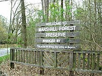 | 1966 | 34°15′03″N 85°11′43″W / 34.250898°N 85.195375°W / 34.250898; -85.195375 (Marshall Forest) | Floyd | private | A loblolly pine-shortleaf pine forest believed to have originated following an intense fire at about the time the Cherokee Indians were forcibly removed to Oklahoma. |
| 8 | Okefenokee Swamp |  | 1974 | 30°37′00″N 82°19′00″W / 30.616667°N 82.316667°W / 30.616667; -82.316667 (Okefenokee Swamp) | Charlton, Clinch, Ware | federal (Okefenokee National Wildlife Refuge) | One of the largest and most primitive swamps in the country. |
| 9 | Panola Mountain | 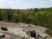 | 1980 | 33°38′07″N 84°10′13″W / 33.635278°N 84.170278°W / 33.635278; -84.170278 (Panola Mountain) | Rockdale | state (Department of Natural Resources) | The most natural and undisturbed monadnock of exposed granitic rock in the Piedmont biophysiographic province. |
| 10 | Wassaw Island | 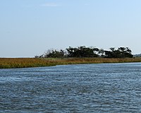 | 1967 | 31°54′01″N 80°58′56″W / 31.9003°N 80.9822°W / 31.9003; -80.9822 (Wassaw Island) | Chatham | federal (Wassaw National Wildlife Refuge) | Only barrier island in Georgia with an undisturbed forest cover. |
| 11 | Wade Tract Preserve | 2014 | 30°45′N 84°00′W / 30.75°N 84°W / 30.75; -84 (Wade Tract Preserve) | Thomas | private | Old growth longleaf pine savanna. |
See also
- v
- t
- e
National Natural Landmarks in the United States
- Alabama
- Alaska
- Arizona
- Arkansas
- California
- Colorado
- Connecticut
- Delaware
- Florida
- Georgia
- Hawaii
- Idaho
- Illinois
- Indiana
- Iowa
- Kansas
- Kentucky
- Louisiana
- Maine
- Maryland
- Massachusetts
- Michigan
- Minnesota
- Mississippi
- Missouri
- Montana
- Nebraska
- Nevada
- New Hampshire
- New Jersey
- New Mexico
- New York
- North Carolina
- North Dakota
- Ohio
- Oklahoma
- Oregon
- Pennsylvania
- Rhode Island
- South Carolina
- South Dakota
- Tennessee
- Texas
- Utah
- Vermont
- Virginia
- Washington
- West Virginia
- Wisconsin
- Wyoming


