Archaeological site in California, United States
United States historic place
|
Last Chance Canyon |
|
|
| |
 The canyon near Cudahy Camp |
35°22′6″N 117°54′28″W / 35.36833°N 117.90778°W / 35.36833; -117.90778 |
| Area | 70,528 acres (28,542 ha) |
|---|
| NRHP reference No. | 72000225[1] |
|---|
| Added to NRHP | December 5, 1972 |
|---|
Last Chance Canyon is a canyon in the El Paso Mountains near Johannesburg, California. The canyon runs from Saltdale in the south to Black Mountain in the north; part of it lies within Red Rock Canyon State Park. The canyon includes a variety of archaeological sites, including pictographs, villages, rock shelters, mills, and quarries. Historic sites such as gold mining camps are also located in the canyon.[2]
The canyon is owned by the U.S. Bureau of Land Management and is open for recreational use. Hiking, camping, and 4-wheel drive vehicles are permitted in most parts of the canyon.[2]
The canyon was added to the National Register of Historic Places on December 5, 1972.[1]
Gallery
References
External links
- Friends of Last Chance Canyon
National Park System |
|---|
| Parks | |
|---|
| Preserves | |
|---|
| Monuments | |
|---|
| Seashores | |
|---|
| Historical Parks | |
|---|
| Historic Sites | |
|---|
| Memorials | |
|---|
| Recreation Areas | |
|---|
|
|
|
|---|
| Parks | |
|---|
| Natural Reserves | |
|---|
| Marine Reserves | |
|---|
| Historic Parks | |
|---|
| Beaches | |
|---|
| Recreation Areas | |
|---|
Vehicular
Recreation Areas | |
|---|
| Other | |
|---|
|
|
National Forests and Grasslands |
|---|
National Forests
and Grasslands | |
|---|
National Wilderness
Preservation System | |
|---|
National Monuments
and Recreation Areas | |
|---|
|
|
|
|
|
|---|
Wildlife
Areas | |
|---|
Ecological
Reserves | |
|---|
Marine
Protected
Areas | |
|---|
|
|
|
|---|
| National Monuments | |
|---|
National
Conservation Areas | - California Desert
- King Range
|
|---|
| Wilderness Areas | |
|---|
|
|
|
|
|
|
|
|
|---|
| Topics | |
|---|
| Lists by state | |
|---|
| Lists by insular areas | |
|---|
| Lists by associated state | |
|---|
| Other areas | |
|---|
| Related | |
|---|
 National Register of Historic Places portal National Register of Historic Places portal Category Category
|

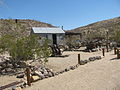 Cabin at Bickel Camp
 Workshop at Bickel Camp
 Otto Adams' gold mining claim
 South end of the canyon
 The canyon near Cudahy Camp


