LA postcode area
Postcode area within the United Kingdom
54°10′23″N 2°54′25″W / 54.173°N 2.907°W / 54.173; -2.907
LA
Lancaster
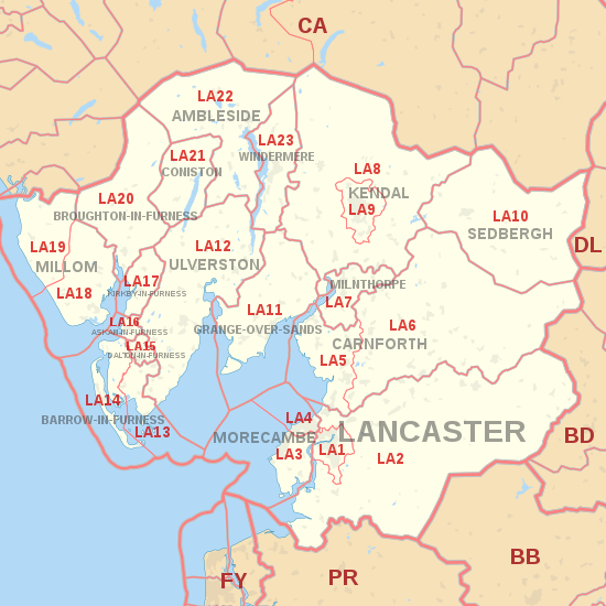
The LA postcode area, also known as the Lancaster postcode area,[2] is a group of 23 postcode districts in north-west England, within 17 post towns. These cover north Lancashire (including Lancaster, Morecambe and Carnforth) and southern Cumbria (including Barrow-in-Furness, Kendal, Ulverston, Windermere, Dalton-in-Furness, Milnthorpe, Sedbergh, Grange-over-Sands, Askam-in-Furness, Kirkby-in-Furness, Broughton-in-Furness, Coniston and Ambleside and Millom), and part of North Yorkshire.
Coverage
The approximate coverage of the postcode districts:
Map
KML file (edit • help)
Template:Attached KML/LA postcode area
KML is from Wikidata
See also
References
- ^ "ONS Postcode Directory Version Notes" (ZIP). National Statistics Postcode Products. Office for National Statistics. May 2020. Table 2. Retrieved 19 June 2020. Coordinates from mean of unit postcode points, "Code-Point Open". OS OpenData. Ordnance Survey. February 2012. Retrieved 21 April 2012.
- ^ Royal Mail, Address Management Guide, (2004)
External links
- Royal Mail's Postcode Address File
- A quick introduction to Royal Mail's Postcode Address File (PAF)
- v
- t
- e
- AB
- AL
- B
- BA
- BB
- BD
- BH
- BL
- BN
- BR
- BS
- BT
- CA
- CB
- CF
- CH
- CM
- CO
- CR
- CT
- CV
- CW
- DA
- DD
- DE
- DG
- DH
- DL
- DN
- DT
- DY
- E
- EC
- EH
- EN
- EX
- FK
- FY
- G
- GL
- GU
- HA
- HD
- HG
- HP
- HR
- HS
- HU
- HX
- IG
- IP
- IV
- KA
- KT
- KW
- KY
- L
- LA
- LD
- LE
- LL
- LN
- LS
- LU
- M
- ME
- MK
- ML
- N
- NE
- NG
- NN
- NP
- NR
- NW
- OL
- OX
- PA
- PE
- PH
- PL
- PO
- PR
- RG
- RH
- RM
- S
- SA
- SE
- SG
- SK
- SL
- SM
- SN
- SO
- SP
- SR
- SS
- ST
- SW
- SY
- TA
- TD
- TF
- TN
- TQ
- TR
- TS
- TW
- UB
- W
- WA
- WC
- WD
- WF
- WN
- WR
- WS
- WV
- YO
- ZE
- Related UK lists: Postcode districts
- Post towns
- Postal counties
- London postal district


