Kernytsia
Rural locality in Lviv Oblast, Ukraine
Village in Lviv Oblast, Ukraine
Kernytsia Керниця | |
|---|---|
village | |
| 49°46′52″N 23°45′20″E / 49.78111°N 23.75556°E / 49.78111; 23.75556 | |
| Country |  Ukraine Ukraine |
| Province |  Lviv Oblast Lviv Oblast |
| District | Lviv Raion |
| Established | 1465 |
| Area | |
| • Total | 1,655 km2 (639 sq mi) |
| Elevation /(average value of) | 281 m (922 ft) |
| Population | |
| • Total | 1,500 |
| • Density | 9,063/km2 (23,470/sq mi) |
| Time zone | UTC+2 (EET) |
| • Summer (DST) | UTC+3 (EEST) |
| Postal code | 81550 |
| Area code | +380 3231 |
| Website | селище Керниця (Ukrainian) |
Kernytsia (Ukrainian: Керни́ця) is a village (selo) in Lviv Raion, Lviv Oblast, of Western Ukraine. Chuchenosy villages name has been in antiquities. The modern name of village was constituted in 1780. It belongs to Horodok urban hromada, one of the hromadas of Ukraine.[1] Local government is administered by Kernytska village council. [2]
Geography
The village is located at a distance of 3 kilometres (1.9 mi) from the highway in Ukraine  M 11 connecting Lviv with Przemyśl. A distance from Kernytsia to Horodok is 8 kilometres (5.0 mi), to the regional center of Lviv is 28 kilometres (17 mi) and 75 kilometres (47 mi) to Przemyśl.
History and Attractions
The first mention of Kernytsia dates from the year 1465.[3] On the territory of village was a German colony Brundorf before World War II. The village was burned during World War II.
Until 18 July 2020, Kernytsia belonged to Horodok Raion. The raion was abolished in July 2020 as part of the administrative reform of Ukraine, which reduced the number of raions of Lviv Oblast to seven. The area of Horodok Raion was merged into Lviv Raion.[4][5]
The village has an architectural monument of local importance of Horodok Raion (Horodok district) – Church of the Exaltation of the Cross 1888 (1572 –м).[6]
-
 Exaltation of the Holy Cross Church (1888)
 -
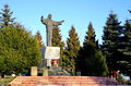 Statue of Jesus Christ


References
- ^ "Городокская городская громада" (in Russian). Портал об'єднаних громад України.
- ^ Керницька сільська рада (in Ukrainian)
- ^ [1] (in Ukrainian)
- ^ "Про утворення та ліквідацію районів. Постанова Верховної Ради України № 807-ІХ". Голос України (in Ukrainian). 2020-07-18. Retrieved 2020-10-03.
- ^ "Нові райони: карти + склад" (in Ukrainian). Міністерство розвитку громад та територій України.
- ^ uk: Пам'ятки архітектури Городоцького району
External links
- village Kernytsia
- weather.in.ua
- КАРПАТИ.INFO/Керниця
Literature
- Ukrainian: Історія міст і сіл УРСР : Львівська область. – К. : ГРУРЕ, 1968 р. Page 259
- v
- t
- e


- Andriyaniv
- Artyschiv
- Bar
- Bartativ
- Berezets
- Bircza
- Bratkovychi
- Buchaly
- Velyka Kalinka
- Vyshnya
- Vovchukhy
- Volya-Bartativska
- Halychany
- Hodvyshnya
- Hrabyne
- Hradivka
- Hrimne
- Dobrjany
- Dolyniany
- Drozdovychy
- Dubanevychi
- Zabolottia
- Zavereshytsya
- Zavydovychi
- Zaluzhany
- Zaluzhzhya
- Zashkovychi
- Zelenyi Gay
- Zushytsi
- Katerynychi
- Kernytsia
- Klitsko
- Koropuzh
- Kosivets
- Lytovka
- Livchytsi
- Lisnovychi
- Lyubovychi
- Mavkovychi
- Malyi Lubin
- Malovanka
- Mylchitsі
- Mylyatyn
- Moloshky
- Monastyrets
- Mosty
- Mshana
- Nove Selo
- Palanyky
- Peremozhne
- Pidzvirynets
- Pidmohylka
- Pisky
- Poberezhne
- Povitno
- Polyana
- Porichchya
- Porichchya Zadvirne
- Porichchya-Hruntove
- Putyatychi
- Rechychany
- Rodatychi
- Romanivka
- Stodilky
- Suhovolya
- Tataryniv
- Tershakiv
- Tulyholove
- Tuchapy
- Uhry
- Hyshevychi
- Cherlyany
- Cherlyanske Peredmistya
- Chulovychi
- Sholomynychi
- Yakymchytsi
- Yaremkiv
 | This article about a location in Lviv Oblast is a stub. You can help Wikipedia by expanding it. |
- v
- t
- e


