Grey Stone of Trough
Historic boundary marker in Lancashire, England


Grey Stone of Trough
Location in the Forest of Bowland
Show map of the Forest of Bowland
Grey Stone of Trough
Location in Ribble Valley
Show map of the Borough of Ribble Valley
Grey Stone of Trough
Location in the City of Lancaster district
Show map of the City of Lancaster district
Grey Stone of Trough
Location in Lancashire
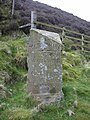
Show map of LancashireThe Grey Stone of Trough is an historic boundary marker in Bowland Forest High, in the Trough of Bowland, Lancashire, England.[1] A Grade II listed structure, erected in 1897 and standing on Trough Road,[2][3] it marks the line of the pre-1974 county boundary between Lancashire and the West Riding of Yorkshire.[3] Historically, the Trough marked the westernmost boundary of the ancient Lordship of Bowland.
It is in sandstone and has a triangular section with inscriptions on the two sides that face the road.
Inscriptions
- Lancashire side
"To Lancaster, 12 miles. Bay Horse, 10 miles"
- Yorkshire side
"To Whitewell, 5 miles. Clitheroe, 12.5 miles"
Gallery
-
 The Yorkshire side of the marker
 -
 The Lancashire side of the marker


References
- ^ Hughes, R. A. (1987). "Geology of the Trough of Bowland area (SD 65 SW) : part of 1:50,000 Sheets 59 (Lancaster) and 67 (Garstang)". www.bgs.ac.uk. Retrieved 15 January 2023.
- ^ Historic England. "BOUNDARY STONE AT SD 622 530 (1362241)". National Heritage List for England. Retrieved 19 December 2021.
- ^ a b Craven Local Plan, November 2019, Craven District Council, p. 94
- v
- t
- e
Buildings and structures in the Borough of Ribble Valley
| |
| Places of worship |
|
|---|---|
| Places of worship |
|
|---|---|
| |
| Places of worship |
|
|---|---|
monuments
| Places of worship |
|
|---|---|
- Mills in Clitheroe
- Listed in Aighton, Bailey & Chaigley
- Balderstone
- Bashall Eaves
- Billington & Langho
- Bolton-by-Bowland
- Bowland-with-Leagram
- Bowland Forest High
- Bowland Forest Low
- Chatburn
- Chipping
- Clayton-le-Dale
- Clitheroe
- Downham
- Dutton
- Easington
- Gisburn
- Gisburn Forest
- Great Mitton
- Grindleton
- Horton
- Hothersall
- Little Mitton
- Longridge
- Mearley
- Mellor
- Middop
- Newsholme
- Newton
- Osbaldeston
- Paythorne
- Pendleton
- Read
- Ribchester
- Rimington
- Sabden
- Salesbury
- Sawley
- Simonstone
- Slaidburn
- Thornley-with-Wheatley
- Twiston
- Waddington
- West Bradford
- Whalley
- Wiswell
- Worston
 | This article about a Lancashire building or structure is a stub. You can help Wikipedia by expanding it. |
- v
- t
- e


