Egmont Bight

Egmont Bight is a shallow embayment at the southern end of the Encombe valley in Dorset, England. It is part of the Jurassic Coast.
Geology
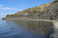
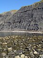
The bay exposes good sections of Upper Kimmeridge shale and mudstone, with some bituminous shale and some small calcareous nodules.[1]

On foot the stony beach is only accessible at low tide by walking 1.0-kilometre (0.6 mi) west around Egmont Point from the beach at Chapman's Pool. There is no safe route down from the clifftop coast path, across Houns-tout cliff, nor around the Freshwater Steps promontory at the beach's western end.
See also
References
- ^ "West, I.M. (2007) Chapman's Pool (Chapmans Pool), Houns-tout and Egmont Bight, Kimmeridge region, Dorset; Geology of the Wessex Coast". Retrieved 26 October 2008.
Gallery
-
 Egmont Bight
 -
 Stony beach, Egmont Bight
 -
 East end of the beach
 -
 West end of the beach
 -
 East side of the small Freshwater Steps promontory
 -
 Cliff-fall of shale on the beach


50°35′42″N 2°4′38″W / 50.59500°N 2.07722°W / 50.59500; -2.07722
- v
- t
- e
Jurassic Coast
- Orcombe Point
- Sandy Bay
- Straight Point
- Otter Cove
- Budleigh Salterton
- Danger Point
- Ladram Bay
- High Peak
- Sidmouth
- Salcombe Hill
- Weston Mouth
- Branscombe
- Beer Head
- Beer Quarry Caves
- Beer
- Seaton
- Pinhay Bay
- Monmouth Beach
- Ware Cliffs
| Chesil Beach | |
|---|---|
| Isle of Portland | |
| Weymouth |
- Furzy Cliff
- Jordan Hill
- Bowleaze Cove
- Broadrock
- Redcliff Point
- Black Head
- Osmington Mills
- Bran Point
- Perry Ledge
- Ringstead
- Ringstead Bay
- White Nothe
- Chaldon Hill
- Bat's Head
- Swyre Head
- Scratchy Bottom
- Durdle Door
- Man o' War Cove
- St Oswald's Bay
- Pinion Rock
- Dungy Head
- Stair Hole
- Lulworth Cove
- Lulworth Ranges
- Purbeck Monocline
- Bindon Hill
- Fossil Forest
- Mupe Bay
- Arish Mell
 | This Dorset location article is a stub. You can help Wikipedia by expanding it. |
- v
- t
- e


