Čertižné
Municipality in Slovakia
49°21′N 21°50′E / 49.350°N 21.833°E / 49.350; 21.833 Slovakia
 (2021)
067 52[3]
Čertižné (Rusyn: Чертижне; Hungarian: Nagycsertész) is a village and municipality in the Medzilaborce District in the Prešov Region of far north-eastern Slovakia.
History
In historical records the village was first mentioned in 1431. Before the establishment of independent Czechoslovakia in 1918, it was part of Zemplén County within the Kingdom of Hungary.
Geography
The municipality lies at an altitude of 452 metres and covers an area of 23.729 km². It has a population of about 405 people.
Genealogical resources
The records for genealogical research are available at the state archive "Statny Archiv in Presov, Slovakia"
- Roman Catholic church records (births/marriages/deaths): 1786-1898 (parish B)
- Greek Catholic church records (births/marriages/deaths): 1819-1926 (parish A)
Gallery
-
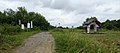
 Čertižné village panorama (March 2015)
 -
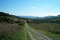
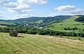 A view of Čertižné and the local landscape (August 2016)
 -
 Greek Catholic Church of the Ascension of the Lord in Čertižné
 -
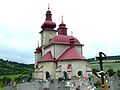 Greek Catholic Church of the Ascension of the Lord and cemetery in Čertižné
 -
 Memorial plaque of A. Dobriansky (1817-1901) in Čertižné (in Rusyn)
 -
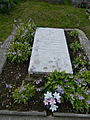 The grave of A. Dobriansky at the cemetery in Čertižné
 -
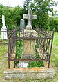 The grave of J. I. Stavrovskij at the cemetery in Čertižné
 -
 The Czeremcha-Čertižné foot-only border crossing between Poland and Slovakia (mountain pass footpath)
 -
 The Jaśliska-Čertižné foot-only border crossing between Poland and Slovakia


See also
References
- ^ "Počet obyvateľov podľa pohlavia - obce (ročne)". www.statistics.sk (in Slovak). Statistical Office of the Slovak Republic. 2022-03-31. Retrieved 2022-03-31.
- ^ a b "Hustota obyvateľstva - obce [om7014rr_ukaz: Rozloha (Štvorcový meter)]". www.statistics.sk (in Slovak). Statistical Office of the Slovak Republic. 2022-03-31. Retrieved 2022-03-31.
- ^ a b c d "Základná charakteristika". www.statistics.sk (in Slovak). Statistical Office of the Slovak Republic. 2015-04-17. Retrieved 2022-03-31.
- ^ a b "Hustota obyvateľstva - obce". www.statistics.sk (in Slovak). Statistical Office of the Slovak Republic. 2022-03-31. Retrieved 2022-03-31.
External links
 Media related to Čertižné at Wikimedia Commons
- Official website

- Čertižné - The Carpathian Connection
- http://www.statistics.sk/mosmis/eng/run.html
- Surnames of living people in Certizne

A small village of about 390 people (2006). The number of inhabitants actively being reduced.
Authority control databases | |
|---|---|
| International |
|
| National |
|
 | This Prešov Region geography article is a stub. You can help Wikipedia by expanding it. |
- v
- t
- e


